Old Maps of Washington County, Maine for Metal Detecting
Plan your next treasure hunt with 627 historic maps of Washington County. Find old homesites, ghost towns, trails, and gathering spots that may be lost to time — perfect for identifying promising metal detecting locations.
- Locate forgotten sites: Uncover places like long-lost settlements, abandoned rail lines, or gathering spots.
- Plan better hunts: Use map overlays combined with LiDAR or satellite views to narrow in on historically rich areas.
- Made for detectorists: Thousands of hobbyists use these maps to discover relics, coins, and hidden history.
Use these historic maps to boost your research and find new opportunities beneath the surface of Washington County.
Washington County, ME maps
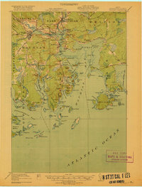
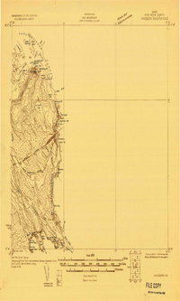
(627)- 1902 Map of Cherryfield, 1962 Print
 1902 Cherryfield1962 Print · USGSCoastal Washington County comes alive in the early 1900s, showing the vital connections between tidal rivers and the rails. Genealogists can trace family roots in Milbridge and Cherryfield, or locate old landings along the Steamboat Route.2 unique versions available
 - 1904 Map of Cherryfield
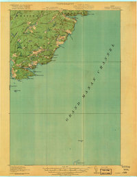
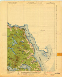
 1904 Cherryfield1904 Print · USGSThe coastal and barrens landscape of Washington County is captured here at the start of the twentieth century. Genealogists and local historians can trace family-named points and early settlements from Cherryfield down to the shores of Narraguagus Bay and Millbridge.5 unique versions available
 - 1904 Map of Petit Manan
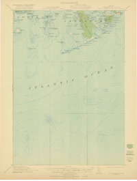
 1904 Petit Manan1904 Print · USGSThe rugged coastline of Washington and Hancock Counties comes alive in this early-century survey. Trace maritime history through the Steamboat Route and local landmarks like Corea, the Petit Manan I. L.H., and Bois Bubert Island.4 unique versions available
 - 1907 Map of Eastport
 1907 Eastport1907 Print · USGSCoastal Washington County is seen here at the height of its maritime and rail era, detailing the intricate shorelines between Eastport and Lubec. Researchers can trace the Washington County Railway through Ayers Junction or locate local landmarks like North Lubec Landing and the Burnt Cove School.
 - 1908 Map of Eastport
 1908 Eastport1908 Print · USGSMaine's easternmost coastline comes alive in the early twentieth century, showing the bustling island city of Eastport and the sardine-packing hub of Lubec. Genealogists can trace family footprints at rural schoolhouses like Crosby School or follow the Washington County Railway to Ayers Junction.4 unique versions available
 - 1917 Map of Cutler, 1965 Print
 1917 Cutler1965 Print · USGSCoastal Washington County is shown here during the late First World War era as a landscape of isolated fishing villages and rocky peninsulas. Genealogists and researchers can trace local landmarks like Moose River School, the village of Cutler, and family-named spots such as Harmon Heath.
 - 1918 Map of Machias
 1918 Machias1918 Print · USGSThe Downeast coast of Washington County comes alive in the years during the Great War, showing the maritime and rail infrastructure that drove the regional economy. Genealogists and historians can trace family-named landmarks and old coastal outposts like Dog Town, Fort O'Brien Point, and the Cross Island L S S.5 unique versions available
 - 1918 Map of Cutler
 1918 Cutler1918 Print · USGSThe Downeast coast of Washington County is captured here just after the Great War, showing a landscape defined by maritime industry and remote schools. Genealogists can trace early homesteads and community sites like School No 2, Moose River School, and the rocky outposts of Machias Seal I.5 unique versions available
 - 1921 Map of Great Wass Island
 1921 Great Wass Island1921 Print · USGSThe Washington County coast appears as a intricate maze of granite islands and narrow channels in the years following the Great War. Maritime researchers can locate the Moose Peak L H, the Coast Guard Sta, and remote harbors like Mistake Harbor.4 unique versions available
 - 1921 Map of Columbia Falls
 1921 Columbia Falls1921 Print · USGSCoastal Washington County is captured here in the early twentieth century as a busy network of river ports and rail-linked interior towns. Genealogists and historians can trace family locations through rural schoolhouses like The Basin School and maritime hubs such as Jonesport, Beals, and Columbia Falls.
 - 1921 Map of Columbia Falls
 1921 Columbia Falls1921 Print · USGSCoastal Washington County at the start of the twenties reveals a landscape defined by tidal reaches and the Maine Central Railroad. Genealogists can locate family homes near Tibbetts Town, Jonesport, and numerous local schools like the White School or Monsapec School.4 unique versions available
 - 1929 Map of Calais
 1929 Calais1929 Print · USGSThe international border along the St. Croix River comes alive in the late 1920s, showing a landscape defined by rail lines and river industry. Genealogists and historians can trace the foundations of local life at Grove PO, Damon Sch, and the riverside works at Milltown.4 unique versions available
 - 1929 Map of Robbinston
 1929 Robbinston1929 Print · USGSThe Maine-New Brunswick border comes to life in the late twenties as this survey traces the international waters of the St Croix River. Genealogists and historians can locate rural landmarks like South Robbinston Sch, Charlotte Sta, and several coastal lighthouses.3 unique versions available
 - 1929 Map of Lead Mountain
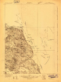
 1929 Lead Mountain1929 Print · USGSThe Maine backcountry near the Hancock and Washington County line is shown here in the late twenties, dominated by timberlands and glacial lakes. Genealogists and historians can locate remote outposts like Jacobs Camp, the Howe Farm, and the trails surrounding Lead Mountain.
 - 1930 Map of Vanceboro
 1930 Vanceboro1930 Print · USGSThe Maine and New Brunswick border comes alive in 1930, centering on the rail hub of Vanceboro and the St Croix River. Trace early 20th-century landmarks like the Cold Water Tavern, Camp Solitaire, and the intricate river rapids at Pork Rips.2 unique versions available
 - 1930 Map of Tunk Lake
 1930 Tunk Lake1930 Print · USGSHancock County was a landscape of timber and tide in the early 1930s, where the Maine Central rail line linked small coastal villages to the deep woods. Genealogists and historians can trace old homesteads in Donnells, rural education at Tunk Lake Sch, and the locations of sporting retreats like the Wichyup Club.
 - 1931 Map of Springfield
 1931 Springfield1931 Print · USGSPenobscot and Washington counties in the early 1930s reveal a landscape of ridges, bogs, and scattered timber camps. Genealogists can trace early rural life through features like Poplar Tavern Camp, the Dill Ridge Fire Tower, and numerous district schools like Cole Sch.4 unique versions available
 - 1931 Map of Robbinston
 1931 Robbinston1931 Print · USGSThe Maine coast near Robbinston and the Canadian border is captured here during the interwar years as a landscape of maritime navigation and rural communities. Genealogists can trace family landmarks and local schools like Bog Brook Sch, Shore Sch, and the riverside village of Red Beach.4 unique versions available
 - 1932 Map of Tunk Lake
 1932 Tunk Lake1932 Print · USGSThe coastal inlets and glacial highlands of Hancock County are meticulously detailed in the early 1930s. Researchers can trace the Maine Central rail line through Sullivan and locate vanished local landmarks like the Think Lake Sch and Wickypup Club.4 unique versions available
 - 1932 Map of Calais
 1932 Calais1932 Print · USGSCoastal Washington County at the start of the 1930s is defined by the international river border and the busy corridors of the Maine Central RR. Genealogists and local historians can locate old rural schoolhouses like Damon Sch or trace the timber-and-rail industry through Woodland Junc and Young Siding.4 unique versions available
 - 1932 Map of Nicatous Lake
 1932 Nicatous Lake1932 Print · USGSNicatous Lake and the surrounding Maine wilderness are captured here in the early 1930s, when private sporting retreats and seasonal camps dotted the shoreline. Genealogists and local historians can trace specific locations like the Explorers Club, Adler Tavern Camp, and Sullivan Camp.4 unique versions available
 - 1932 Map of Lead Mountain
 1932 Lead Mountain1932 Print · USGSThe Maine timberlands and the historic Air Line Road are captured here in the early thirties, showcasing a landscape of isolated logging camps and remote lakes. Researchers can locate family-named sites like Howe Farm Camp, the settlements of Deblois and Beddington, and the Fire Tower atop Lead Mountain.5 unique versions available
 - 1933 Map of Vanceboro
 1933 Vanceboro1933 Print · USGSVanceboro and the Canadian borderlands are captured here in the early 1930s as the rail and river economy flourished. Genealogists and historians can trace the Maine Central rail lines and locate early landmarks like Ice House Pt, Sussie Hill, and Lambert Lake.4 unique versions available
 - 1934 Map of Nicatous Lake
 1934 Nicatous Lake1934 Print · USGSHancock County was a landscape of remote sporting camps and timber trails in the early 1930s. Genealogists and historians can trace old sites like Poplar Tavern Camp, the Nicatous Club, and No 2 Camp set among landmarks like Duck Mtn.4 unique versions available
 - 1934 Map of Springfield
 1934 Springfield1934 Print · USGSPenobscot County in the 1930s is a landscape of rural schoolhouses and timberlands surrounding Springfield and Carroll. Genealogists and historians can trace family-named locations such as Tolman Sch, Gowell Sch, and Bridge Farm.4 unique versions available
Showing maps 1-25 of 627
Top cities of Washington County
- Calais historical maps
- Machias historical maps
- Milbridge historical maps
- East Machias historical maps
- Baileyville historical maps
- Eastport historical maps
See more
Frequently asked questions
- What are the different types of historical maps available for Washington County?
- What is the oldest map of Washington County?
- Where can I purchase historical maps of Washington County for my home or office?
- Where can I download high-res historical maps of Washington County?
- Are there historical topographic maps available for Washington County?
- Is there historical aerial imagery available for Washington County?
- Where are historical maps of Washington County sourced from?