1950s Maps of Annapolis, Maryland
Explore 9 historic maps of Annapolis from the 1950s. These maps offer a rare glimpse into what life looked like during the 1950s — showing old roads, neighborhoods, homes, and landmarks that have changed or disappeared over time.
Whether you're researching your family's past, planning a metal detecting trip, or studying how Annapolis's landscape evolved across the 1950s, these high-resolution maps are a powerful tool for exploring the history of this region.
- Focus on a specific era: All maps on this page are from the 1950s, giving you a focused view of this time period.
- See what’s changed: Compare century-old streets, trails, and buildings to today's modern landscape using overlays and satellite layers.
- Research with precision: Use these maps for genealogy, historical research, land use analysis, or educational projects.
- View, download, or print: Maps are fully viewable online in high resolution, and can be downloaded or printed for your own records.
Start exploring Annapolis's history through authentic maps from the 1950s. This is your window into the past.
Annapolis, MD maps
(9)- 1953 Map of Annapolis
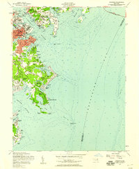
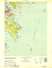 1953 Annapolis1953 Print · USGSThe Annapolis waterfront during the early 1950s shows a dense landscape of naval facilities and coastal settlements. Genealogists and historians can trace the development of Eastport, Arundel on the Bay, and the historic U S Naval Academy.
 - 1954 Map of Baltimore
 1954 Baltimore1954 Print · USGSThe Mid-Atlantic region in the early fifties shows a landscape of growing suburban centers and heavy rail corridors. Trace mid-century transit networks and military landmarks from the Aberdeen Proving Ground to the Gettysburg National Military Park.
 - 1954 Map of Gibson Island, 1955 Print
 1954 Gibson Island1955 Print · USGSAnne Arundel County's shoreline was a hub of maritime navigation and coastal development in the mid-fifties. Genealogists and historians can trace family locations in St Margarets or Skidmore and locate landmarks like the State Prison Camp and Baltimore Lighthouse.5 unique versions available
 - 1956 Map of Baltimore
 1956 Baltimore1956 Print · USGSMid-century Maryland and Pennsylvania are captured here during a period of massive suburban and military growth across the Chesapeake region. Genealogists and historians can trace the rail corridors of the Baltimore & Ohio RR and locate landmarks like Fort McHenry or the Aberdeen Proving Ground.
 - 1956 Map of Round Bay, 1960 Print
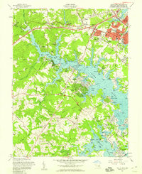
 1956 Round Bay1960 Print · USGSAnne Arundel County is captured here in the mid-1950s as its tidal shorelines transitioned into vibrant residential communities. Genealogists and local historians can trace the Baltimore and Annapolis Railroad corridor through Earleigh Heights and locate landmarks like the Crownsville State Hospital.4 unique versions available
 - 1957 Map of South River, 1958 Print
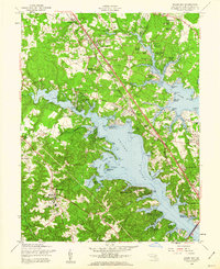
 1957 South River1958 Print · USGSThe South River and its labyrinth of tidal coves define this coastal Maryland landscape during the postwar boom. Genealogists and local historians can trace family-named points and early church sites like All Hallows Ch and Hopes Chapel, alongside the growth of Parole and Edgewater.6 unique versions available
 - 1957 Map of Annapolis, 1958 Print
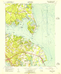
 1957 Annapolis1958 Print · USGSMid-century Annapolis and its surrounding peninsula are captured here as suburban growth begins to reach the Chesapeake shoreline. Researchers can trace the layout of the U S Naval Academy, find local landmarks like St Marys Church, or locate vanished leisure spots like Carrs Beach.5 unique versions available
 - 1957 Map of Baltimore, 1964 Print
 1957 Baltimore1964 Print · USGSMaryland and Southern Pennsylvania are shown during the mid-century expansion of the Baltimore-Washington corridor. Researchers can trace the extensive rail lines of the Baltimore & Ohio RR and locate sites like Fort Detrick and Gettysburg National Military Park.5 unique versions available
 - 1957 Map of Washington, 1966 Print
 1957 Washington1966 Print · USGSThe mid-Atlantic region during the mid-fifties and early sixties reveals a landscape of growing suburbs and vital military outposts. Researchers can trace historic river towns and shorelines from Alexandria to the Hooper Islands and St Clements Island.5 unique versions available
End of results
Showing maps 1-9 of 9
Top cities near Annapolis
- Glen Burnie historical maps
- Bowie historical maps
- Odenton historical maps
- Severna Park historical maps
- Crofton historical maps
- Pasadena historical maps
See more
Top neighborhoods of Annapolis
- Mariners Point historical maps
- Wilshire historical maps
- Victor Haven historical maps
- Georgetown East historical maps
- Captains Walk historical maps
- Thurgood Marshall Memorial Plaza historical maps
See more
Frequently asked questions
- What are the different types of historical maps available for Annapolis?
- What is the oldest map of Annapolis?
- Where can I purchase historical maps of Annapolis for my home or office?
- Where can I download high-res historical maps of Annapolis?
- Are there historical topographic maps available for Annapolis?
- Is there historical aerial imagery available for Annapolis?
- Where are historical maps of Annapolis sourced from?