1960s Maps of Baltimore County, Maryland
Explore 5 historic maps of Baltimore County from the 1960s. These maps offer a rare glimpse into what life looked like during the 1960s — showing old roads, neighborhoods, homes, and landmarks that have changed or disappeared over time.
Whether you're researching your family's past, planning a metal detecting trip, or studying how Baltimore County's landscape evolved across the 1960s, these high-resolution maps are a powerful tool for exploring the history of this region.
- Focus on a specific era: All maps on this page are from the 1960s, giving you a focused view of this time period.
- See what’s changed: Compare century-old streets, trails, and buildings to today's modern landscape using overlays and satellite layers.
- Research with precision: Use these maps for genealogy, historical research, land use analysis, or educational projects.
- View, download, or print: Maps are fully viewable online in high resolution, and can be downloaded or printed for your own records.
Start exploring Baltimore County's history through authentic maps from the 1960s. This is your window into the past.
Baltimore County, MD maps
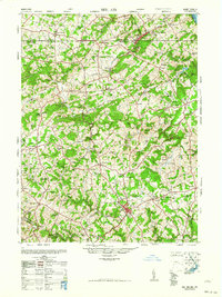
(5)- 1961 Map of Baltimore
 1961 Baltimore1961 Print · USGSMaryland and Pennsylvania are captured at a mid-century peak of industrial and military expansion. Genealogists and historians can trace rail corridors like the Western Maryland Ry or locate regional landmarks such as Camp Detrick and Kent Island.
 - 1963 Map of Belair
 1963 Belair1963 Print · USGSHarford County and the Pennsylvania border are shown just after the war, when the Maryland and Pennsylvania RR still served these communities. Genealogists can locate family-named landmarks like the Broad Creek Meeting House, the Wheeler School, and St Ignatius Church.
 - 1969 Map of Sparrows Point, 1971 Print
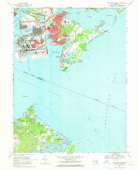 1969 Sparrows Point1971 Print · USGSThe industrial Patapsco shoreline and Chesapeake Bay beaches meet in the late sixties, showcasing the peak of the steel era. Genealogists can trace family footprints from Dundalk to coastal enclaves like Paradise Beach and Fairview.3 unique versions available
 - 1969 Map of Middle River, 1971 Print
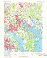 1969 Middle River1971 Print · USGSCoastal Baltimore County is captured in a moment of rapid postwar growth, centered on the aviation and rail hubs of the Middle River area. Researchers can trace the layout of early suburbs like Victory Villa and Essex or locate landmarks such as the Battle Monument and Martin Airport.4 unique versions available
 - 1969 Map of Curtis Bay, 1971 Print
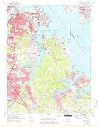 1969 Curtis Bay1971 Print · USGSThe northern reaches of Anne Arundel County are captured in the late sixties as industrial growth met a rising suburban waterfront. Genealogists and historians can trace family roots through numerous sites like Cedar Hill Cemetery, Sollys Cem, and schools from Harundale to Brooklyn Park.2 unique versions available
End of results
Showing maps 1-5 of 5
Top cities of Baltimore County
- Dundalk historical maps
- Towson historical maps
- Catonsville historical maps
- Woodlawn historical maps
- Essex historical maps
- Randallstown historical maps
See more
Frequently asked questions
- What are the different types of historical maps available for Baltimore County?
- What is the oldest map of Baltimore County?
- Where can I purchase historical maps of Baltimore County for my home or office?
- Where can I download high-res historical maps of Baltimore County?
- Are there historical topographic maps available for Baltimore County?
- Is there historical aerial imagery available for Baltimore County?
- Where are historical maps of Baltimore County sourced from?