1940s Maps of Baltimore County, Maryland
Explore 37 historic maps of Baltimore County from the 1940s. These maps offer a rare glimpse into what life looked like during the 1940s — showing old roads, neighborhoods, homes, and landmarks that have changed or disappeared over time.
Whether you're researching your family's past, planning a metal detecting trip, or studying how Baltimore County's landscape evolved across the 1940s, these high-resolution maps are a powerful tool for exploring the history of this region.
- Focus on a specific era: All maps on this page are from the 1940s, giving you a focused view of this time period.
- See what’s changed: Compare century-old streets, trails, and buildings to today's modern landscape using overlays and satellite layers.
- Research with precision: Use these maps for genealogy, historical research, land use analysis, or educational projects.
- View, download, or print: Maps are fully viewable online in high resolution, and can be downloaded or printed for your own records.
Start exploring Baltimore County's history through authentic maps from the 1940s. This is your window into the past.
Baltimore County, MD maps
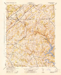
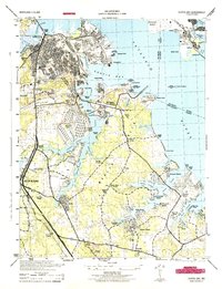
(37)- 1941 Map of Gunpowder
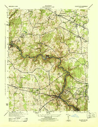
 1941 Gunpowder1941 Print · USGSThe Chesapeake tidewater and the Gunpowder River valley are caught in their pre-war rural state in this early 1940s survey. Researchers can trace the paths of the P.R.R. System and locate historic sites like Harford Furnace and Osbornes Ruins.
 - 1942 Map of Laurel
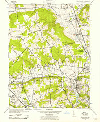
 1942 Laurel1942 Print · USGSMaryland's corridor between Baltimore and Washington is seen here in the early 1940s as a land of rural schoolhouses and riverside mills. Researchers can trace family sites near Muirkirk, find the original Christian Brothers College, or locate historic river crossings like Brock Bridge and Duvall Bridge.
 - 1942 Map of Bel Air
 1942 Bel Air1942 Print · USGSHarford and York counties at the start of the 1940s show a landscape shaped by the Maryland and Pennsylvania R.R. and deep-cut creek valleys. Trace the local rail-and-mill economy through Clermont Mills, Whiteford, and the village of Delta near the state line.
 - 1942 Map of Swan Point
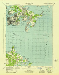
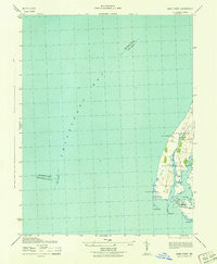 1942 Swan Point1942 Print · USGSKent County's shoreline and the waters of the Chesapeake are captured here in the early 1940s. Genealogists and maritime historians can trace the settlements of Gratitude and Edesville No 5 alongside landmarks like Swan Point and The Haven.
 - 1943 Map of North Point
 1943 North Point1943 Print · USGSThe Chesapeake Bay's maritime approaches are captured here during the 1940s, highlighting the industrial strength of Sparrows Point and the coastal defenses at Fort Howard. Researchers can trace the rail connections at Love Point Landing or explore the mid-century waterfronts of Gibson Island and Bay Shore.
 - 1943 Map of Cockeysville, 1958 Print
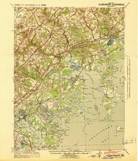
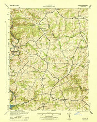
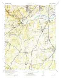
 1943 Cockeysville1958 Print · USGSBaltimore County in the early forties shows a landscape of grand estates and burgeoning suburbs along the PENNSYLVANIA railroad. Researchers can locate vanished landmarks like the Eccleston P O or trace early footprints at Druid Ridge Cemetery and Saters Church.
 - 1943 Map of Baltimore, 1963 Print
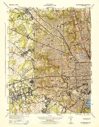
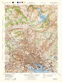
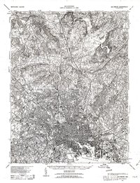 1943 Baltimore1963 Print · USGSMaryland's principal port city and the rolling hills of Baltimore County are shown here during the Second World War. Researchers can trace the heritage of the harbor and northern suburbs, identifying landmarks like Fort McHenry National Mon, Loudon Park National Cem, and the old Ashland Furnace.3 unique versions available
 - 1944 Map of Baltimore West
 1944 Baltimore West1944 Print · USGSWestern Baltimore and its suburban fringes are frozen in time during the mid-1940s, showing a landscape of institutional campuses and growing streetcar suburbs. Genealogists and historians can locate family sites near Loudon Park Cemetery, St Agnes Hospital, and Pimlico Race Track.
 - 1944 Map of New Freedom
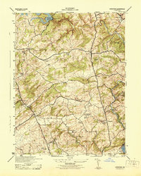
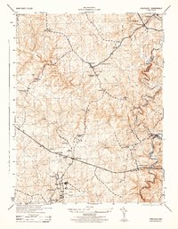
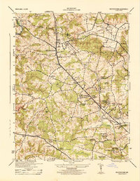
 1944 New Freedom1944 Print · USGSThe Pennsylvania-Maryland border during the mid-forties reveals a rural landscape of tight-knit communities centered on the Pennsylvania Railroad. Genealogists and historians can trace the foundations of local life through the Summit Grove Camp Meeting, Bentley Springs, and the 6th District Consolidated School.
 - 1944 Map of Sykesville
 1944 Sykesville1944 Print · USGSMid-century Carroll and Howard counties are captured here just as the rural estate and railroad economies were evolving. Genealogists and historians can trace family locations near Doughoregan Manor, local burials at Mountain View Cemetery, or old rail stops at Gaither and Henryton.
 - 1944 Map of Hampstead
 1944 Hampstead1944 Print · USGSMaryland's rolling borderlands between Carroll and Baltimore counties are captured here during the mid-forties. Genealogists and historians can trace the rail-side growth of Hampstead, the rural post office at Arcadia Upperco P O, and industry at Trenton Mill.
 - 1944 Map of Ellicott City
 1944 Ellicott City1944 Print · USGSMaryland's Patapsco Valley comes alive in this wartime survey, showing the industrial river corridor and developing uplands between Howard and Baltimore counties. Researchers can trace the Baltimore and Ohio rail lines past Woodstock College, Alberton, and the busy streets of Ellicott City.
 - 1944 Map of Hereford
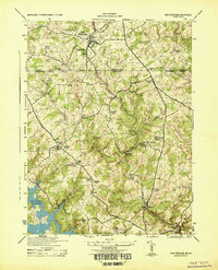
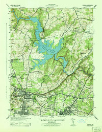
 1944 Hereford1944 Print · USGSNorthern Baltimore County is captured during the mid-1940s, a period when the rural landscape was increasingly shaped by massive water projects. Genealogists can trace family footprints near White Hall or Hereford, or locate specific sites like Gunpowder Meeting House and the Mushroom Sheds.
 - 1944 Map of Towson
 1944 Towson1944 Print · USGSMid-century Baltimore County shows a landscape of growing academic campuses and quiet reservoir shores just north of the city limits. Researchers can trace the footprints of Goucher College, the Loch Raven Dam, and local landmarks like Cromwell Bridge.2 unique versions available
 - 1944 Map of Norrisville
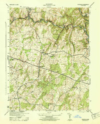
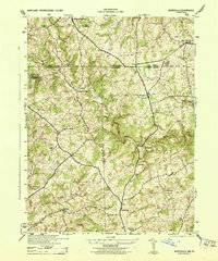 1944 Norrisville1944 Print · USGSMaryland and Pennsylvania borderlands meet along the Mason and Dixon Line during the mid-1940s. Genealogists and researchers can trace rural life through landmarks like Ivory Mill, Ebaughs School, and the McKendree Church.
 - 1944 Map of Lineboro
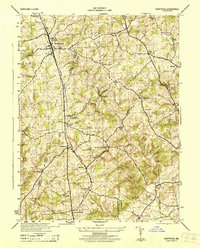
 1944 Lineboro1944 Print · USGSMaryland and Pennsylvania border life is captured here in the mid-1940s, centered on the Mason and Dixon Line. Researchers can trace rural genealogy and land use through landmarks like Baughmans Mill, Stiltz, and the Blackrock Chapel & School.
 - 1944 Map of Phoenix
 1944 Phoenix1944 Print · USGSBaltimore and Harford counties meet here during the mid-1940s, a landscape of historic manors and river-driven commerce. Genealogists can trace family roots through numerous country parishes like Clynmalira Church and small rural hubs like Monkton and Jacksonville.
 - 1944 Map of Cockeysville
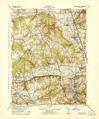 1944 Cockeysville1944 Print · USGSThe northern Baltimore County suburbs were in a period of transition during the mid-forties as rail lines connected established towns with new recreational estates. Genealogists and historians can trace family plots at Druid Ridge Cemetery or locate wartime military activity at the Maryland State Fair Grounds.
 - 1944 Map of Baltimore
 1944 Baltimore1944 Print · USGSMid-century Baltimore and its northern suburbs are shown in exceptional detail at the height of the war years. Local historians can trace the early footprints of Johns Hopkins University, the defenses at Fort McHenry, and the rural character of Green Spring Valley before modern development.
 - 1944 Map of Curtis Bay
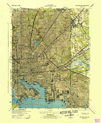
 1944 Curtis Bay1944 Print · USGSCoastal Maryland during the war years reveals a landscape of massive military depots and burgeoning shorefront communities. Genealogists and historians can trace rail lines like the Baltimore and Annapolis and locate landmarks from Fort Armistead Park to Marley Station.
 - 1944 Map of Finksburg
 1944 Finksburg1944 Print · USGSCarroll County agriculture and industry meet along the Patapsco River during the mid-1940s. Genealogists and local historians can trace family-named landmarks and institutions like Springfield State Hospital, Sykesville, and Comet Roller Mills.2 unique versions available
 - 1944 Map of Baltimore East
 1944 Baltimore East1944 Print · USGSThe industrial heart of Baltimore pulses during the war years, from the busy docks of the Northwest Branch to the military grounds at Camp Holabird. Genealogists and historians can trace neighborhood growth in Highlandtown or locate historic institutions like Taylors Chapel and Notre Dame College.
 - 1944 Map of Sparrows Point
 1944 Sparrows Point1944 Print · USGSThe industrial and maritime heart of the Chesapeake coast is captured here during the wartime height of the 1940s. Genealogists and historians can trace the development of Sparrows Point steel works and find local landmarks like the Edgemere Community Chapel and Bay Shore Park.3 unique versions available
 - 1944 Map of Relay
 1944 Relay1944 Print · USGSMaryland's Patapsco River valley and the rail hubs south of Baltimore are captured here during the mid-forties. Researchers can trace historic church sites like Gaines Church, early industrial markers including the Distilleries near Relay, and named neighborhoods like English Consul.2 unique versions available
 - 1944 Map of Reisterstown
 1944 Reisterstown1944 Print · USGSBaltimore County's rural and institutional landscapes come into sharp focus during the mid-1940s. Genealogists and historians can trace the footprint of early schools and estates like Hannah More Academy, Garrison, and the Gwynnbrook State Game Farm.
Showing maps 1-25 of 37
Top cities of Baltimore County
- Dundalk historical maps
- Towson historical maps
- Catonsville historical maps
- Woodlawn historical maps
- Essex historical maps
- Randallstown historical maps
See more
Frequently asked questions
- What are the different types of historical maps available for Baltimore County?
- What is the oldest map of Baltimore County?
- Where can I purchase historical maps of Baltimore County for my home or office?
- Where can I download high-res historical maps of Baltimore County?
- Are there historical topographic maps available for Baltimore County?
- Is there historical aerial imagery available for Baltimore County?
- Where are historical maps of Baltimore County sourced from?