1950s Maps of Baltimore County, Maryland
Explore 30 historic maps of Baltimore County from the 1950s. These maps offer a rare glimpse into what life looked like during the 1950s — showing old roads, neighborhoods, homes, and landmarks that have changed or disappeared over time.
Whether you're researching your family's past, planning a metal detecting trip, or studying how Baltimore County's landscape evolved across the 1950s, these high-resolution maps are a powerful tool for exploring the history of this region.
- Focus on a specific era: All maps on this page are from the 1950s, giving you a focused view of this time period.
- See what’s changed: Compare century-old streets, trails, and buildings to today's modern landscape using overlays and satellite layers.
- Research with precision: Use these maps for genealogy, historical research, land use analysis, or educational projects.
- View, download, or print: Maps are fully viewable online in high resolution, and can be downloaded or printed for your own records.
Start exploring Baltimore County's history through authentic maps from the 1950s. This is your window into the past.
Baltimore County, MD maps
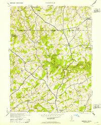
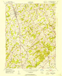
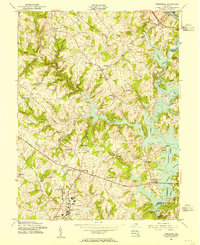
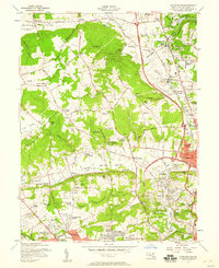
(30)- 1950 Map of Relay
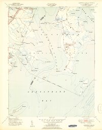
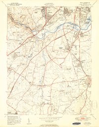 1950 Relay1950 Print · USGSMaryland's corridor between Baltimore and Anne Arundel County is captured here just as the post-war suburban and industrial expansion takes flight. Genealogists and local historians can trace the early layout of Friendship International Airport and find local landmarks like the Thomas Viaduct and All Saints Convent.2 unique versions available
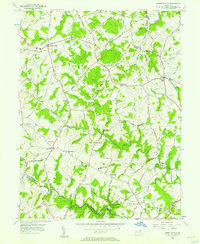
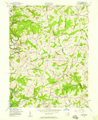
 - 1950 Map of Savage
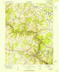
 1950 Savage1950 Print · USGSHoward County and parts of Anne Arundel County are shown here at mid-century, just as suburban expansion began to reshape these rural settlements. Genealogists and historians can trace family-named sites and institutions like St Marys College, Westley Grove, and the Maryland House of Correction.2 unique versions available
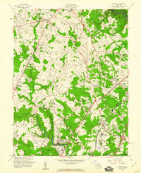
 - 1951 Map of Middle River
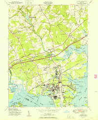
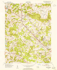
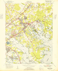 1951 Middle River1951 Print · USGSCoastal Baltimore County comes alive in the early fifties, showing a landscape shaped by military aviation and suburban growth. Trace the history of Middle River and Essex through landmarks like the Essex Seaplane Base, Diffendalls Airfield, and the North Point Battlefield Monument.
 - 1951 Map of White Marsh
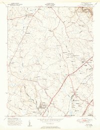
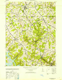
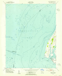
 1951 White Marsh1951 Print · USGSThe Baltimore and Harford county line comes alive in the early fifties as rural hamlets give way to a growing transit corridor. Genealogists and historians can trace family roots through landmarks like Union Chapel Church, Long Green Station, and the old mill site at Franklinville.6 unique versions available
 - 1951 Map of Gunpowder Neck
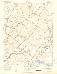
 1951 Gunpowder Neck1951 Print · USGSThe Harford County shoreline and the Gunpowder Neck are captured here in the mid-century as a mix of military expansion and bayfront leisure. Genealogists and historians can trace rail stops like Chase Station, the development of Harewood Park, and the isolated lighthouse at Pooles Island.2 unique versions available
 - 1951 Map of Edgewood
 1951 Edgewood1951 Print · USGSHarford County's coastal corridor is shown here during the post-war expansion of the military and rail networks. Researchers can trace the development of the Army Chemical Center alongside older landmarks like the McComas Institute, Harford Furnace, and St Mary's Church.2 unique versions available
 - 1953 Map of New Freedom
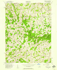
 1953 New Freedom1953 Print · USGSThe Pennsylvania-Maryland border country comes to life in the early fifties, showing the rail-linked hamlets between York and Baltimore counties. Genealogists can trace family roots through sites like Summit Grove Camp Meeting, Heathcote Mill, and Ruhls School.
 - 1953 Map of Baltimore West
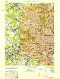 1953 Baltimore West1953 Print · USGSMid-century Baltimore and its western suburbs are caught in a moment of rapid postwar expansion and institutional growth. Genealogists and historians can trace family plots in Loudon Park Cemetery or locate landmarks like Pimlico Race Track and Curtis-Wright Airport.6 unique versions available
 - 1953 Map of Norrisville
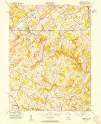
 1953 Norrisville1953 Print · USGSThe Maryland-Pennsylvania border comes alive in this mid-century portrait of the Mason and Dixon Line and its surrounding farming communities. Genealogists and historians can trace the foundations of Norrisville and locate Ebaughs School or Amos Mill.2 unique versions available
 - 1953 Map of Baltimore East
 1953 Baltimore East1953 Print · USGSMid-century Baltimore thrives as a center of industry and education, from the bustling inner harbor to the emerging eastern suburbs. Researchers can trace the legacy of major institutions like Johns Hopkins University, the sprawling Camp Holabird, and the historic Fort McHenry.5 unique versions available
 - 1953 Map of Lineboro, 1954 Print
 1953 Lineboro1954 Print · USGSThe Maryland-Pennsylvania borderlands come alive in this mid-century survey of the rural Gunpowder Falls watershed. Researchers can trace ancestral locations near Lineboro, find several early schools like Hokes Sch, or locate the flooding of the Prettyboy Reservoir.6 unique versions available
 - 1953 Map of Sykesville, 1954 Print
 1953 Sykesville1954 Print · USGSIn the mid-fifties, the Patapsco River valley served as a busy corridor for the Baltimore and Ohio railroad and the Henryton State Hospital. Researchers can trace old homesteads and landmarks like Doughoregan Manor and Mountain View Cemetery along the National Pike.5 unique versions available
 - 1953 Map of Hampstead, 1954 Print
 1953 Hampstead1954 Print · USGSThe borderlands of Carroll and Baltimore counties come alive in the 1950s, showing a region shaped by the Western Maryland railroad. Trace family history through local landmarks like Arcadia (Upperco P O), St Johns Cem, and Loes Mill.4 unique versions available
 - 1953 Map of Ellicott City, 1954 Print
 1953 Ellicott City1954 Print · USGSEllicott City and the Patapsco River valley are captured in the early 1950s as traditional milling towns meet the expanding Baltimore suburbs. Genealogists and local historians can trace family-named sites like Billy Cem, institutional landmarks such as Woodstock College, and the industrial pulse of the Baltimore and Ohio railroad.5 unique versions available
 - 1953 Map of Reisterstown, 1955 Print
 1953 Reisterstown1955 Print · USGSMid-century Baltimore County comes alive in this survey of Reisterstown and its surrounding institutional and rail landscape. Genealogists and historians can trace the foundations of Owings Mills, the Western Maryland Railway, and historic schools like the Hannah More Academy For Girls.6 unique versions available
 - 1953 Map of Swan Point, 1955 Print
 1953 Swan Point1955 Print · USGSThe Kent County shoreline and Chesapeake Bay waters are captured here in the early fifties, documenting the Eastern Shore's maritime character. Trace local history through detailed landings and waterfront settlements like Rock Hall, Gratitude, and Deep Landing.2 unique versions available
 - 1953 Map of Finksburg, 1955 Print
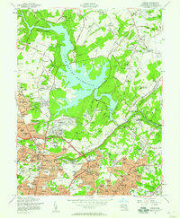
 1953 Finksburg1955 Print · USGSSoutheastern Carroll County is captured here in the early fifties as the rising waters of Liberty Lake reshaped the Patapsco valley. Researchers can trace the legacy of local institutions like the Springfield State Hospital and Strawbridge Home for Boys.5 unique versions available
 - 1954 Map of Baltimore
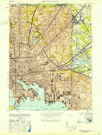
 1954 Baltimore1954 Print · USGSThe Mid-Atlantic region in the early fifties shows a landscape of growing suburban centers and heavy rail corridors. Trace mid-century transit networks and military landmarks from the Aberdeen Proving Ground to the Gettysburg National Military Park.
 - 1956 Map of Baltimore
 1956 Baltimore1956 Print · USGSMid-century Maryland and Pennsylvania are captured here during a period of massive suburban and military growth across the Chesapeake region. Genealogists and historians can trace the rail corridors of the Baltimore & Ohio RR and locate landmarks like Fort McHenry or the Aberdeen Proving Ground.
 - 1956 Map of Jarrettsville, 1957 Print
 1956 Jarrettsville1957 Print · USGSHarford County's rural character is well-preserved here in the mid-1950s, showing the settlement patterns of the Maryland piedmont. Researchers can trace family history through sites like Old Brick Ch, Youths Benefit School, and the Pennsylvania rail line.4 unique versions available
 - 1957 Map of Norrisville, 1958 Print
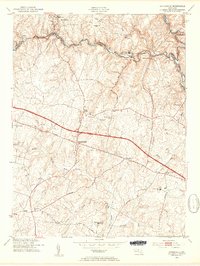
 1957 Norrisville1958 Print · USGSThe Mason-Dixon line divides this rural landscape in the 1950s, where Harford and York counties meet. Genealogists and historians can trace the Baltimore and Pennsylvania RR and locate old landmarks like Gorsuch Mills, Ivory Mill, and Ayers Chapel.4 unique versions available
 - 1957 Map of Towson, 1958 Print
 1957 Towson1958 Print · USGSMid-century Baltimore County shows a mix of suburban growth and institutional presence surrounding the massive Loch Raven Reservoir. Local historians can trace early neighborhood footprints in Rodgers Forge and locate landmarks like Goucher College and the Loch Raven Dam.4 unique versions available
 - 1957 Map of Cockeysville, 1958 Print
 1957 Cockeysville1958 Print · USGSBaltimore County in the mid-fifties is captured here as suburban growth begins to follow the rail lines and valleys north of the city. Genealogists and local researchers can trace old estates and institutions such as Saters Ch, Druid Ridge Cemetery, and the Villa Julia Jr College.6 unique versions available
 - 1957 Map of Phoenix, 1958 Print
 1957 Phoenix1958 Print · USGSThe northern Maryland countryside at the end of the fifties reveals a landscape of historic manors and emerging suburban hamlets. Researchers can trace the Pennsylvania Railroad corridor and locate landmarks like the Elkridge-Harford Hunt Club, Houcks Mill, and My Ladys Manor.4 unique versions available
 - 1957 Map of Savage, 1960 Print
 1957 Savage1960 Print · USGSHoward County and Anne Arundel County appear in the late fifties as a landscape of crossroads hamlets and significant institutional sites. Researchers can trace the grounds of the Maryland House of Correction, the Laurel Harness Racing Track, and family landmarks like St Johns Cem.6 unique versions available
Showing maps 1-25 of 30
Top cities of Baltimore County
- Dundalk historical maps
- Towson historical maps
- Catonsville historical maps
- Woodlawn historical maps
- Essex historical maps
- Randallstown historical maps
See more
Frequently asked questions
- What are the different types of historical maps available for Baltimore County?
- What is the oldest map of Baltimore County?
- Where can I purchase historical maps of Baltimore County for my home or office?
- Where can I download high-res historical maps of Baltimore County?
- Are there historical topographic maps available for Baltimore County?
- Is there historical aerial imagery available for Baltimore County?
- Where are historical maps of Baltimore County sourced from?