1950s Maps of Dorchester County, Maryland
Explore 4 historic maps of Dorchester County from the 1950s. These maps offer a rare glimpse into what life looked like during the 1950s — showing old roads, neighborhoods, homes, and landmarks that have changed or disappeared over time.
Whether you're researching your family's past, planning a metal detecting trip, or studying how Dorchester County's landscape evolved across the 1950s, these high-resolution maps are a powerful tool for exploring the history of this region.
- Focus on a specific era: All maps on this page are from the 1950s, giving you a focused view of this time period.
- See what’s changed: Compare century-old streets, trails, and buildings to today's modern landscape using overlays and satellite layers.
- Research with precision: Use these maps for genealogy, historical research, land use analysis, or educational projects.
- View, download, or print: Maps are fully viewable online in high resolution, and can be downloaded or printed for your own records.
Start exploring Dorchester County's history through authentic maps from the 1950s. This is your window into the past.
Dorchester County, MD maps
(4)- 1955 Map of Sharptown, 1957 Print
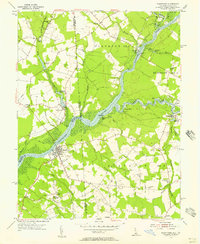 1955 Sharptown1957 Print · USGSThe Nanticoke River and Broad Creek dominate this mid-century look at the Maryland and Delaware border. Genealogists can trace family roots through Sharptown and Galestown, or locate historic river crossings like the Woodland Ferry and Baileys Landing.2 unique versions available
 - 1955 Map of Seaford West, 1957 Print
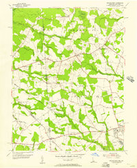 1955 Seaford West1957 Print · USGSSussex County, Delaware, is captured in the mid-fifties at the Maryland state line, showing a landscape of small crossroads and creek-side industry. Researchers can trace family roots through Old Liberty Ch, Wrights Cem, and the rural Blocksom Sch.2 unique versions available
 - 1957 Map of Salisbury
 1957 Salisbury1957 Print · USGSThe Delmarva Peninsula in the mid-1950s reveals a landscape of coastal defenses and rail-driven commerce. Researchers can trace the Pennsylvania railroad lines or locate historic landmarks like the Fenwick Island Lighthouse and St Martin church.
 - 1957 Map of Washington, 1966 Print
 1957 Washington1966 Print · USGSThe mid-Atlantic region during the mid-fifties and early sixties reveals a landscape of growing suburbs and vital military outposts. Researchers can trace historic river towns and shorelines from Alexandria to the Hooper Islands and St Clements Island.5 unique versions available
End of results
Showing maps 1-4 of 4
Top cities of Dorchester County
- Cambridge historical maps
- Hurlock historical maps
- Secretary historical maps
- Vienna historical maps
- East New Market historical maps
- Church Creek historical maps
See more
Frequently asked questions
- What are the different types of historical maps available for Dorchester County?
- What is the oldest map of Dorchester County?
- Where can I purchase historical maps of Dorchester County for my home or office?
- Where can I download high-res historical maps of Dorchester County?
- Are there historical topographic maps available for Dorchester County?
- Is there historical aerial imagery available for Dorchester County?
- Where are historical maps of Dorchester County sourced from?