1950s Maps of Walkersville, Maryland
Explore 6 historic maps of Walkersville from the 1950s. These maps offer a rare glimpse into what life looked like during the 1950s — showing old roads, neighborhoods, homes, and landmarks that have changed or disappeared over time.
Whether you're researching your family's past, planning a metal detecting trip, or studying how Walkersville's landscape evolved across the 1950s, these high-resolution maps are a powerful tool for exploring the history of this region.
- Focus on a specific era: All maps on this page are from the 1950s, giving you a focused view of this time period.
- See what’s changed: Compare century-old streets, trails, and buildings to today's modern landscape using overlays and satellite layers.
- Research with precision: Use these maps for genealogy, historical research, land use analysis, or educational projects.
- View, download, or print: Maps are fully viewable online in high resolution, and can be downloaded or printed for your own records.
Start exploring Walkersville's history through authentic maps from the 1950s. This is your window into the past.
Walkersville, MD maps
(6)- 1953 Map of Walkersville
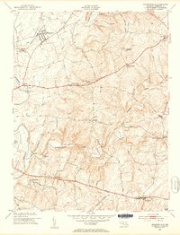 1953 Walkersville1953 Print · USGSMid-century Frederick County comes to life in this survey of the agrarian lands around the Monocacy River and the growing town of Walkersville. Genealogists can trace family footprints at Glade Cem, Silver Hill Ch, and old crossroads like McKaig or Daysville.8 unique versions available
 - 1953 Map of Frederick, 1954 Print
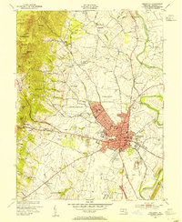 1953 Frederick1954 Print · USGSMaryland's interior growth is on full display here during the early fifties as the city of Frederick pushes toward Catoctin Mountain. Researchers can trace the layout of the U S Military Reservation at Camp Detrick and locate local landmarks like Hood College and Mt Olivet Cemetery.8 unique versions available
 - 1953 Map of Woodsboro, 1955 Print
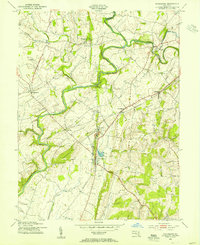 1953 Woodsboro1955 Print · USGSMid-century Frederick County, Maryland, is captured here during a time of active rail transport and river-valley farming. Genealogists and researchers can locate family landmarks like Rocky Hill Ch, the Fish Hatchery, and the old rail stop at Rocky Ridge.6 unique versions available
 - 1954 Map of Baltimore
 1954 Baltimore1954 Print · USGSThe Mid-Atlantic region in the early fifties shows a landscape of growing suburban centers and heavy rail corridors. Trace mid-century transit networks and military landmarks from the Aberdeen Proving Ground to the Gettysburg National Military Park.
 - 1956 Map of Baltimore
 1956 Baltimore1956 Print · USGSMid-century Maryland and Pennsylvania are captured here during a period of massive suburban and military growth across the Chesapeake region. Genealogists and historians can trace the rail corridors of the Baltimore & Ohio RR and locate landmarks like Fort McHenry or the Aberdeen Proving Ground.
 - 1957 Map of Baltimore, 1964 Print
 1957 Baltimore1964 Print · USGSMaryland and Southern Pennsylvania are shown during the mid-century expansion of the Baltimore-Washington corridor. Researchers can trace the extensive rail lines of the Baltimore & Ohio RR and locate sites like Fort Detrick and Gettysburg National Military Park.5 unique versions available
End of results
Showing maps 1-6 of 6
Top cities near Walkersville
- Frederick historical maps
- Ballenger Creek historical maps
- Damascus historical maps
- Urbana historical maps
- Linganore historical maps
- Taneytown historical maps
See more
Top neighborhoods of Walkersville
- Fountain Rock Manor historical maps
- Spring View Estates historical maps
- Sun Meadow historical maps
- Colony Village historical maps
- Glade Town historical maps
- Deerfield historical maps
Frequently asked questions
- What are the different types of historical maps available for Walkersville?
- What is the oldest map of Walkersville?
- Where can I purchase historical maps of Walkersville for my home or office?
- Where can I download high-res historical maps of Walkersville?
- Are there historical topographic maps available for Walkersville?
- Is there historical aerial imagery available for Walkersville?
- Where are historical maps of Walkersville sourced from?