1900s (20th Century) Maps of Prince George's County, Maryland
Explore 98 historic maps of Prince George's County from the 1900s (20th Century). These maps offer a rare glimpse into what life looked like during the 1900s — showing old roads, neighborhoods, homes, and landmarks that have changed or disappeared over time.
Whether you're researching your family's past, planning a metal detecting trip, or studying how Prince George's County's landscape evolved across the 1900s, these high-resolution maps are a powerful tool for exploring the history of this region.
- Focus on a specific era: All maps on this page are from the 1900s, giving you a focused view of this time period.
- See what’s changed: Compare century-old streets, trails, and buildings to today's modern landscape using overlays and satellite layers.
- Research with precision: Use these maps for genealogy, historical research, land use analysis, or educational projects.
- View, download, or print: Maps are fully viewable online in high resolution, and can be downloaded or printed for your own records.
Start exploring Prince George's County's history through authentic maps from the 1900s. This is your window into the past.
Prince George's County, MD maps
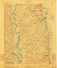
(98)- 1900 Map of Washington
 1900 Washington1900 Print · USGSThe capital region at the turn of the century shows a landscape of river-borne commerce and expanding rail lines. Genealogists and historians can trace defunct transport links like the Shepherd Ferry and early suburbs like North Takoma and Jackson City.2 unique versions available
 - 1901 Map of Prince Frederick
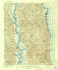
 1901 Prince Frederick1901 Print · USGSThe Tidewater region of Maryland is captured here at the dawn of the twentieth century, when river travel and steamship wharves still defined the local economy. Researchers can locate vanished landings and ferry crossings like Magruder Ferry, Leitch Wharf, and Lower Marlboro.
 - 1905 Map of Owensville
 1905 Owensville1905 Print · USGSCoastal Maryland in the early twentieth century was a landscape of tide-water wharves and rural post offices. Genealogists can trace family connections through sites like Owensville West River PO, Hartges Wharf, and Mitchellville PO.5 unique versions available
 - 1906 Map of Patuxent
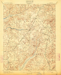
 1906 Patuxent1906 Print · USGSThe Tidewater region of Maryland and the outskirts of the District of Columbia are shown here at the turn of the century. Researchers can trace the early footprints of Maryland Agril. College, find riverfront infrastructure at Milltown Landing, and follow long-established routes like the Marlboro Turnpike.4 unique versions available
 - 1907 Map of Laurel
 1907 Laurel1907 Print · USGSMaryland's transit corridor between Washington and Baltimore comes alive in the early 1900s as railroads and old turnpikes cross the Patuxent valley. Trace historical landmarks from the House of Reformation to old crossings like Old Forge Bridge and Brock Bridge.3 unique versions available
 - 1907 Map of Relay
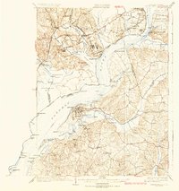
 1907 Relay1907 Print · USGSAnne Arundel County and the Patapsco waterfront are shown here in the early nineteen-hundreds, as industry and maritime trade reshaped the Maryland coast. Genealogists and historians can trace rail lines and early settlements like Relay and Elkridge, or locate landmarks such as Fort Carroll and St. Stephens Church.8 unique versions available
 - 1908 Map of Patapsco
 1908 Patapsco1908 Print · USGSMaryland's central corridor at the opening of the twentieth century reveals a dense network of harbor defenses and rail-line economies. Genealogists and historians can trace the foundations of Baltimore alongside local landmarks like Ashland Furnace, St Charles College, and Fort McHenry.4 unique versions available
 - 1910 Map of Prince Frederick
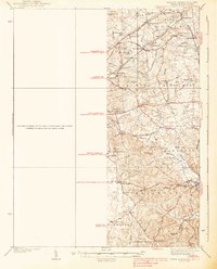
 1910 Prince Frederick1910 Print · USGSCoastal Calvert County comes alive in the early twentieth century, showing a landscape defined by the Patuxent River and the bay. Genealogists can trace old wharves and family settlements from Lower Marlboro to the Chesapeake Beach RR line.3 unique versions available
 - 1911 Map of Brandywine, 1962 Print
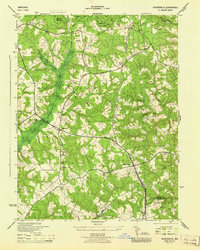
 1911 Brandywine1962 Print · USGSSouthern Maryland at the turn of the century shows a landscape of rail-connected farming towns and expansive wetlands. Researchers can trace ancestral locations near LA PLATA, the old Reform School, or country parishes like St Peters Church and Piney Church.
 - 1913 Map of Brandywine
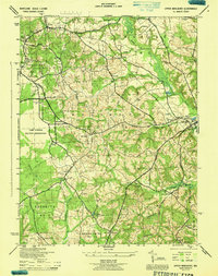
 1913 Brandywine1913 Print · USGSSouthern Maryland at the turn of the century shows a landscape transitioning through early rail and rural growth. Genealogists can trace family roots through landmarks like St Peters Church, Winkler Shop School, and old stops such as Malcolm Woodville Station.3 unique versions available
 - 1913 Map of Indian Head
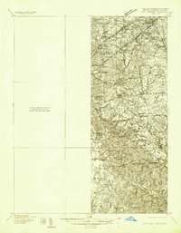
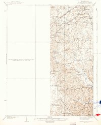
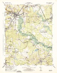
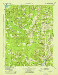
 1913 Indian Head1913 Print · USGSThe Potomac River tidewater south of the capital was a region of defensive forts and busy river landings before the First World War. Researchers can trace the early layout of the Naval Proving Grounds and locate family landmarks like Mattinglys Wharf or the Granny Thompson School.2 unique versions available
 - 1923 Map of Indian Head
 1923 Indian Head1923 Print · USGSMaryland and Virginia meet along the Potomac in the 1920s, a period when steamboats and early highways still defined regional travel. Genealogists can trace family footprints through sites like Marshall Hall PO, Pohick Church, and the Woodlawn School (Colored).2 unique versions available
 - 1925 Map of Indian Head
 1925 Indian Head1925 Print · USGSThe Potomac River corridor in the mid-1920s reveals a landscape of strategic military installations and historic river landings. Genealogists and local historians can trace the foundations of Indian Head, find local landmarks like Pohick Church, or locate defunct river hubs such as Budds Ferry.6 unique versions available
 - 1926 Map of Laurel
 1926 Laurel1926 Print · USGSThe corridor between Baltimore and Washington is captured here in the mid-twenties, showcasing a landscape of river-powered industry and early rail networks. Genealogists can locate family landmarks like Hicks Mill, the Willis School, and the Montgomery Chapel Cem.4 unique versions available
 - 1934 Map of Upper Marlboro (east half)
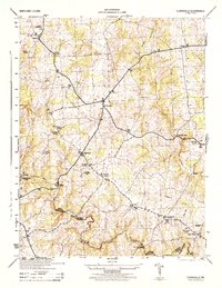
 1934 Upper Marlboro (east half)1934 Print · USGSPrince George's County is captured here in the mid-1930s as a rural landscape of crossroads communities and evolving rail lines. Genealogists and historians can trace family roots through landmarks like St Luke Ch, Glenarden Sch, and the route of the Chesapeake Beach RR.2 unique versions available
 - 1937 Map of Upper Marlboro
 1937 Upper Marlboro1937 Print · USGSMid-century Prince George’s County is captured here just as modern highways began to intersect its rural rail and school districts. Researchers can find old landmarks like St Barnabas Ch, the Collington Sch, and the busy Pennsylvania railroad line.
 - 1938 Map of Prince Frederick
 1938 Prince Frederick1938 Print · USGSCalvert County at the height of the 1930s reveals a Maryland landscape defined by tobacco farming and bay-front resorts. Researchers can locate vanished rural landmarks like the Cedar Hill Sch, explore the wharves at Deep Landing, or trace the early layout of Chesapeake Beach.3 unique versions available
 - 1938 Map of Upper Marlboro
 1938 Upper Marlboro1938 Print · USGSPrince George's County at the dawn of the modern era is captured here, showing the rural landscape before the post-war expansion. Researchers can trace family sites near Holy Trinity Ch, follow the Pennsylvania RR line, and locate centers like Rosaryville and Glenn Dale.3 unique versions available
 - 1942 Map of Laurel
 1942 Laurel1942 Print · USGSMaryland's corridor between Baltimore and Washington is seen here in the early 1940s as a land of rural schoolhouses and riverside mills. Researchers can trace family sites near Muirkirk, find the original Christian Brothers College, or locate historic river crossings like Brock Bridge and Duvall Bridge.
 - 1944 Map of Piscataway
 1944 Piscataway1944 Print · USGSSouthern Maryland was a landscape of rural airfields and country parishes in the 1940s. Genealogists and historians can trace the foundations of Waldorf and Piscataway, locating local landmarks like Hyde Field Army Air Base and St Marys Church.
 - 1944 Map of Laurel
 1944 Laurel1944 Print · USGSMaryland's interior between Baltimore and Washington shows a landscape of federal research and military activity during the war years. Genealogists and historians can trace the foundations of Greenbelt, the historic Laurel Race Track, and the specialized facilities of the Beltsville Research Center.
 - 1944 Map of Port Tobacco
 1944 Port Tobacco1944 Print · USGSCharles County during the mid-1940s reveals a landscape of rural hamlets and emerging military infrastructure. Genealogists and local historians can trace family locations near Pomfret, the Mt Carmel Monastery, and the historic Port Tobacco PO.
 - 1944 Map of Hughesville
 1944 Hughesville1944 Print · USGSSouthern Maryland during the mid-forties remained a land of sprawling wetlands and rural crossroads at the intersection of three counties. Genealogists and historians can trace family locations near St Marys Ch, the old Burnt Store settlement, and along the U S Navy rail corridor.
 - 1944 Map of Upper Marlboro
 1944 Upper Marlboro1944 Print · USGSMaryland's tidewater interior was transforming during the Second World War as defense installations met traditional crossroads communities. Genealogists and historians can trace family-named sites like Berry Lane or Westphalia, and locate early parish life at St Barnabas Chapel and Holy Rosary Ch.
 - 1944 Map of Clarksville
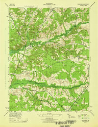
 1944 Clarksville1944 Print · USGSHoward County's agricultural heartland is documented here in the mid-1940s, showing the early crossroads and river crossings of the Maryland interior. Genealogists can locate family landmarks like Atholton Church, the Dayton School, and several rural cemeteries near Clarksville.
Showing maps 1-25 of 98
Top cities of Prince George's County
- Bowie historical maps
- Clinton historical maps
- College Park historical maps
- Chillum historical maps
- South Laurel historical maps
- Suitland historical maps
See more
Frequently asked questions
- What are the different types of historical maps available for Prince George's County?
- What is the oldest map of Prince George's County?
- Where can I purchase historical maps of Prince George's County for my home or office?
- Where can I download high-res historical maps of Prince George's County?
- Are there historical topographic maps available for Prince George's County?
- Is there historical aerial imagery available for Prince George's County?
- Where are historical maps of Prince George's County sourced from?