1920s Maps of Prince George's County, Maryland
Explore 3 historic maps of Prince George's County from the 1920s. These maps offer a rare glimpse into what life looked like during the 1920s — showing old roads, neighborhoods, homes, and landmarks that have changed or disappeared over time.
Whether you're researching your family's past, planning a metal detecting trip, or studying how Prince George's County's landscape evolved across the 1920s, these high-resolution maps are a powerful tool for exploring the history of this region.
- Focus on a specific era: All maps on this page are from the 1920s, giving you a focused view of this time period.
- See what’s changed: Compare century-old streets, trails, and buildings to today's modern landscape using overlays and satellite layers.
- Research with precision: Use these maps for genealogy, historical research, land use analysis, or educational projects.
- View, download, or print: Maps are fully viewable online in high resolution, and can be downloaded or printed for your own records.
Start exploring Prince George's County's history through authentic maps from the 1920s. This is your window into the past.
Prince George's County, MD maps
(3)- 1923 Map of Indian Head
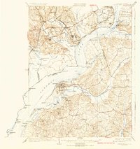
 1923 Indian Head1923 Print · USGSMaryland and Virginia meet along the Potomac in the 1920s, a period when steamboats and early highways still defined regional travel. Genealogists can trace family footprints through sites like Marshall Hall PO, Pohick Church, and the Woodlawn School (Colored).2 unique versions available
 - 1925 Map of Indian Head
 1925 Indian Head1925 Print · USGSThe Potomac River corridor in the mid-1920s reveals a landscape of strategic military installations and historic river landings. Genealogists and local historians can trace the foundations of Indian Head, find local landmarks like Pohick Church, or locate defunct river hubs such as Budds Ferry.6 unique versions available
 - 1926 Map of Laurel
 1926 Laurel1926 Print · USGSThe corridor between Baltimore and Washington is captured here in the mid-twenties, showcasing a landscape of river-powered industry and early rail networks. Genealogists can locate family landmarks like Hicks Mill, the Willis School, and the Montgomery Chapel Cem.4 unique versions available
End of results
Showing maps 1-3 of 3
Top cities of Prince George's County
- Bowie historical maps
- Clinton historical maps
- College Park historical maps
- Chillum historical maps
- South Laurel historical maps
- Suitland historical maps
See more
Frequently asked questions
- What are the different types of historical maps available for Prince George's County?
- What is the oldest map of Prince George's County?
- Where can I purchase historical maps of Prince George's County for my home or office?
- Where can I download high-res historical maps of Prince George's County?
- Are there historical topographic maps available for Prince George's County?
- Is there historical aerial imagery available for Prince George's County?
- Where are historical maps of Prince George's County sourced from?