Old Maps of Prince George's County, Maryland for Hiking & Exploration
Hike through history with 113 historic maps of Prince George's County. Explore old trails, ghost towns, and forgotten backroads — perfect for outdoor adventurers and local explorers.
- Rediscover forgotten places: Map out old mining camps, roads, and footpaths that no longer exist on modern maps.
- Layer with modern tools: Combine with LiDAR or satellite views to plan hikes through historical terrain.
- Made for exploration: Popular among hikers, overlanders, and local history lovers.
Use these maps to find adventure and explore the hidden past of Prince George's County.
Prince George's County, MD maps
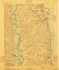
(113)- 1890 Map of Mt. Vernon
 1890 Mt. Vernon1890 Print · USGSCovers Prince George's County, including Washington, Arlington, and other nearby areas
 - 1891 Map of Mt. Vernon
 1891 Mt. Vernon1891 Print · USGSCovers Prince George's County, including Washington, Arlington, and other nearby areas
 - 1892 Map of Laurel
 1892 Laurel1892 Print · USGSCovers Prince George's County, including Columbia, Silver Spring, and other nearby areas
 - 1892 Map of Prince Frederick
 1892 Prince Frederick1892 Print · USGSCovers Prince George's County, including Chesapeake Beach, Dunkirk, and other nearby areas
 - 1892 Map of Brandywine
 1892 Brandywine1892 Print · USGSCovers Prince George's County, including Waldorf, Fort Washington, and other nearby areas
 - 1892 Map of Owensville
 1892 Owensville1892 Print · USGSCovers Prince George's County, including Bowie, Annapolis, and other nearby areas
 - 1894 Map of Laurel
 1894 Laurel1894 Print · USGSCovers Prince George's County, including Columbia, Silver Spring, and other nearby areas4 unique versions available
 - 1894 Map of Relay
 1894 Relay1894 Print · USGSCovers Prince George's County, including Glen Burnie, Bowie, and other nearby areas4 unique versions available
 - 1894 Map of Mt. Vernon, 1904 Print
 1894 Mt. Vernon1904 Print · USGSCovers Prince George's County, including Washington, Arlington, and other nearby areas6 unique versions available
 - 1895 Map of Prince Frederick
 1895 Prince Frederick1895 Print · USGSCovers Prince George's County, including Chesapeake Beach, Dunkirk, and other nearby areas
 - 1895 Map of Brandywine
 1895 Brandywine1895 Print · USGSCovers Prince George's County, including Waldorf, Fort Washington, and other nearby areas2 unique versions available
 - 1895 Map of Owensville
 1895 Owensville1895 Print · USGSCovers Prince George's County, including Bowie, Annapolis, and other nearby areas2 unique versions available
 - 1897 Map of Laurel
 1897 Laurel1897 Print · USGSCovers Prince George's County, including Columbia, Silver Spring, and other nearby areas
 - 1897 Map of Mt. Vernon
 1897 Mt. Vernon1897 Print · USGSCovers Prince George's County, including Washington, Arlington, and other nearby areas2 unique versions available
 - 1899 Map of Patuxent
 1899 Patuxent1899 Print · USGSCovers Prince George's County, including Washington, Waldorf, and other nearby areas3 unique versions available
 - 1900 Map of Washington
 1900 Washington1900 Print · USGSCovers Prince George's County, including Washington, Arlington, and other nearby areas2 unique versions available
 - 1901 Map of Prince Frederick
 1901 Prince Frederick1901 Print · USGSCovers Prince George's County, including Chesapeake Beach, Dunkirk, and other nearby areas
 - 1905 Map of Owensville
 1905 Owensville1905 Print · USGSCovers Prince George's County, including Bowie, Annapolis, and other nearby areas5 unique versions available
 - 1906 Map of Patuxent
 1906 Patuxent1906 Print · USGSCovers Prince George's County, including Washington, Waldorf, and other nearby areas4 unique versions available
 - 1907 Map of Laurel
 1907 Laurel1907 Print · USGSCovers Prince George's County, including Columbia, Silver Spring, and other nearby areas3 unique versions available
 - 1907 Map of Relay
 1907 Relay1907 Print · USGSCovers Prince George's County, including Glen Burnie, Bowie, and other nearby areas8 unique versions available
 - 1908 Map of Patapsco
 1908 Patapsco1908 Print · USGSCovers Prince George's County, including Baltimore, Columbia, and other nearby areas4 unique versions available
 - 1910 Map of Prince Frederick
 1910 Prince Frederick1910 Print · USGSCovers Prince George's County, including Chesapeake Beach, Dunkirk, and other nearby areas3 unique versions available
 - 1911 Map of Brandywine, 1962 Print
 1911 Brandywine1962 Print · USGSCovers Prince George's County, including Waldorf, Fort Washington, and other nearby areas
 - 1913 Map of Brandywine
 1913 Brandywine1913 Print · USGSCovers Prince George's County, including Waldorf, Fort Washington, and other nearby areas3 unique versions available
Showing maps 1-25 of 113
Top cities of Prince George's County
- Bowie historical maps
- Clinton historical maps
- College Park historical maps
- Chillum historical maps
- South Laurel historical maps
- Suitland historical maps
See more
Frequently asked questions
- What are the different types of historical maps available for Prince George's County?
- What is the oldest map of Prince George's County?
- Where can I purchase historical maps of Prince George's County for my home or office?
- Where can I download high-res historical maps of Prince George's County?
- Are there historical topographic maps available for Prince George's County?
- Is there historical aerial imagery available for Prince George's County?
- Where are historical maps of Prince George's County sourced from?