1940s Maps of Queen Anne's County, Maryland
Explore 30 historic maps of Queen Anne's County from the 1940s. These maps offer a rare glimpse into what life looked like during the 1940s — showing old roads, neighborhoods, homes, and landmarks that have changed or disappeared over time.
Whether you're researching your family's past, planning a metal detecting trip, or studying how Queen Anne's County's landscape evolved across the 1940s, these high-resolution maps are a powerful tool for exploring the history of this region.
- Focus on a specific era: All maps on this page are from the 1940s, giving you a focused view of this time period.
- See what’s changed: Compare century-old streets, trails, and buildings to today's modern landscape using overlays and satellite layers.
- Research with precision: Use these maps for genealogy, historical research, land use analysis, or educational projects.
- View, download, or print: Maps are fully viewable online in high resolution, and can be downloaded or printed for your own records.
Start exploring Queen Anne's County's history through authentic maps from the 1940s. This is your window into the past.
Queen Anne's County, MD maps
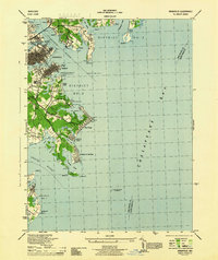
(30)- 1942 Map of Love Point
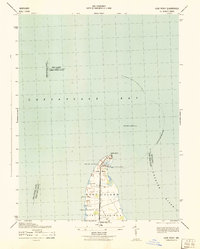 1942 Love Point1942 Print · USGSNorthern Kent Island served as a vital Chesapeake transit hub during the early forties. Trace the rail-to-ferry connection at Love Point Landing and locate landmarks like the Love Point Lighthouse and Cupola Barn.
 - 1942 Map of Claiborne, 1961 Print
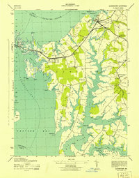
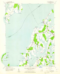 1942 Claiborne1961 Print · USGSCoastal Talbot County is captured here in the early 1940s, featuring the busy rail-to-ferry connection at Claiborne. Genealogists and historians can trace family locations near McDaniel and Bozman, or locate local landmarks like St Johns Ch and Wittman Sch.4 unique versions available
 - 1942 Map of Kent Island, 1961 Print
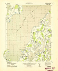
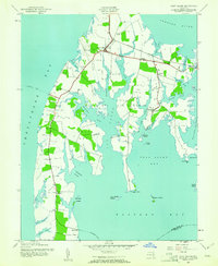 1942 Kent Island1961 Print · USGSKent Island at the onset of the 1940s remained a landscape of ferry landings and rail terminals along the Chesapeake. Genealogists and local historians can trace family locations near Batts Neck Sch, Stevensville, and the Baltimore and Eastern RR line.3 unique versions available
 - 1942 Map of Queenstown, 1961 Print
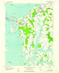 1942 Queenstown1961 Print · USGSMaryland's Eastern Shore at the start of the 1940s reveals a landscape shaped by tidal creeks and the rail-and-water economy. Genealogists can trace family footprints near St Peters Ch, Grasonville Cem, and the historic waterfront of Queenstown.3 unique versions available
 - 1942 Map of Wye Mills, 1961 Print
 1942 Wye Mills1961 Print · USGSThe Eastern Shore comes alive in the 1940s as the Baltimore and Eastern railroad threads through a landscape of tidal creeks and colonial-era parishes. Genealogists can trace family footprints at Old Wye Ch, the crossroads of Skipton, and the small fishing outpost at Wye Landing.2 unique versions available
 - 1942 Map of St. Michaels, 1961 Print
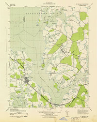
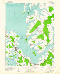 1942 St. Michaels1961 Print · USGSMid-century Talbot County is defined by its winding Chesapeake tributaries and the established harbor at St Michaels. Genealogists and historians can trace the rail-and-water corridors of the Baltimore and Eastern through settlements like Tunis Mills and Newcomb.3 unique versions available
 - 1943 Map of Claiborne
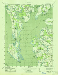
 1943 Claiborne1943 Print · USGSTalbot County’s waterfront communities are captured in the early 1940s, showing a landscape shaped by the Chesapeake Bay and local rail lines. Genealogists and historians can trace the foundations of Claiborne and Sherwood, or locate landmarks like Wesley Church and the McDaniel RR Sta.
 - 1943 Map of Chestertown
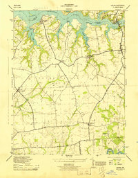
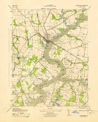 1943 Chestertown1943 Print · USGSMid-century Kent County life centers on the bustling docks and campuses of the Chestertown waterfront during the early years of the war. Researchers can trace the legacy of rural communities through sites like Bond Chapel, the Pennsylvania railroad line, and numerous landings like Riverside Wharf.
 - 1943 Map of North Point
 1943 North Point1943 Print · USGSThe Chesapeake Bay's maritime approaches are captured here during the 1940s, highlighting the industrial strength of Sparrows Point and the coastal defenses at Fort Howard. Researchers can trace the rail connections at Love Point Landing or explore the mid-century waterfronts of Gibson Island and Bay Shore.
 - 1943 Map of Wye Mills
 1943 Wye Mills1943 Print · USGSMaryland's Eastern Shore during the mid-1940s reveals a landscape of tidal creeks and quiet parish life. Genealogists and historians can locate Old Wye Church, the rural Newton School, and the Wye Mills RR Sta along the Baltimore and Eastern line.
 - 1943 Map of Queenstown
 1943 Queenstown1943 Print · USGSThe Eastern Shore comes into focus during the early war years, showing a maritime landscape of tidal rivers and rail lines. Genealogists can trace family connections at St Peters Cem and locate vanished landmarks like the Landing Field or Garnett Church.
 - 1943 Map of Langford Creek
 1943 Langford Creek1943 Print · USGSThe tidewater necks of Kent and Queen Anne's counties are shown in the early 1940s, revealing a landscape of remote farmsteads and waterfront landings. Genealogists can trace early rural communities through landmarks like Mowbray Chapel, Hickory Thicket, and the Prussian Cem.
 - 1943 Map of Kent Island
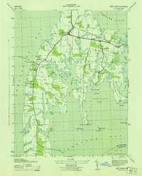 1943 Kent Island1943 Print · USGSKent Island was a vital Chesapeake transit hub during the 1940s, serving as the eastern terminus for the Annapolis-Matapeake Ferry. Trace old rail lines like the Baltimore and Eastern and find community landmarks like Wesley Church and Batts Neck School.
 - 1943 Map of St. Michaels
 1943 St. Michaels1943 Print · USGSMaryland's Eastern Shore appears in the early 1940s as a landscape defined by its intricate waterways and rail-connected hamlets. Genealogists and historians can trace the foundations of local life through labels for St Michaels, Tunis Mills, and St Stevens Church.
 - 1943 Map of Centerville
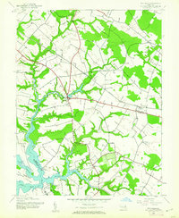
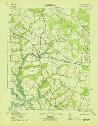
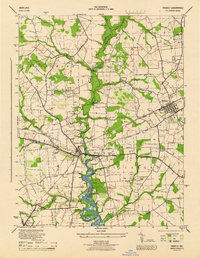
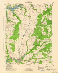
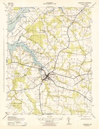 1943 Centerville1943 Print · USGSThis wartime survey of the Maryland Eastern Shore captures the rural character of Queen Anne's County just before mid-century. Genealogists can trace the footprint of family-named landmarks like Ashland Indian Town and rural junctions such as Starkey Corner and Brownsville.
 - 1944 Map of Church Hill
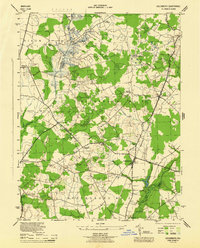
 1944 Church Hill1944 Print · USGSQueen Anne's County was a landscape of river landings and country parishes during the mid-1940s. Genealogists and historians can trace family roots through numerous local landmarks, from Boyer Chapel and Jeffers Chapel to the riverside settlement of Crumpton.
 - 1944 Map of Price
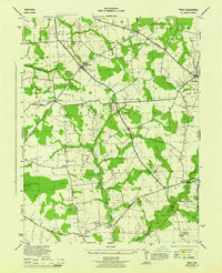 1944 Price1944 Print · USGSQueen Anne's County was a landscape of quiet agricultural hamlets and country parishes during the mid-forties. Genealogists and local historians can trace family roots through landmarks like Bethany Church, the St Gertrude Academy, or the settlement of Price along the Pennsylvania railroad line.4 unique versions available
 - 1944 Map of Ridgely
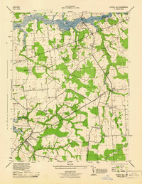
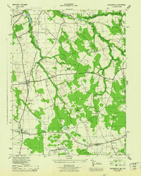
 1944 Ridgely1944 Print · USGSThe Eastern Shore counties of Caroline, Queen Anne's, and Talbot meet along the Tuckahoe Creek during the final years of the war. Researchers can trace the rail corridor of the Baltimore and Eastern and find local landmarks like Adolph Landing and Allan Church.4 unique versions available
 - 1944 Map of Galena
 1944 Galena1944 Print · USGSMaryland's Eastern Shore in the mid-1940s remains a landscape of river wharves and rural parishes tied together by rail. Genealogists can trace historic congregations at Shrewsbury Church and Asbury Ch, or locate old landings like Raisins Wharf and Shellcross Wharf.
 - 1944 Map of Goldsboro
 1944 Goldsboro1944 Print · USGSCaroline County and the surrounding Eastern Shore agricultural lands are shown here in the mid-1940s. Genealogists and local historians can trace the rail-side growth of Goldsboro and Henderson or locate rural sites like Ervings Chapel and Bethel School.4 unique versions available
 - 1944 Map of Annapolis
 1944 Annapolis1944 Print · USGSCoastal Maryland at the height of the war years reveals a landscape defined by naval expansion and developing bayside communities. Researchers can trace the mid-century footprints of Highland Beach, the U S Naval Academy, and the historic Thomas Point Shoal Lighthouse.
 - 1944 Map of Millington
 1944 Millington1944 Print · USGSUpper Kent County and the Delaware borderlands come alive in the mid-1940s, highlighting a landscape defined by rail junctions and river systems. You can trace family roots through small communities like Golts, Massey, and Crumpton, or locate historic sites like St Clements Church.
 - 1944 Map of Sudlersville
 1944 Sudlersville1944 Print · USGSThe rural borderlands of Maryland and Delaware are captured here in the mid-1940s, centered on the rail corridor at Sudlersville. Researchers can trace old family crossroads like Schenk Corners or locate country sites such as Prices Chapel and Busicks Ch.
 - 1946 Map of Wilmington, 1948 Print
 1946 Wilmington1948 Print · USGSThe Delaware Valley and Jersey Shore emerge in this mid-century portrait of a region defined by river commerce and seaside growth. Genealogists and historians can trace the rail networks of the Pennsylvania Railroad, locate early airfields like Dover Airpark, and find river defenses at Fort Delaware.2 unique versions available
 - 1946 Map of Salisbury, 1948 Print
 1946 Salisbury1948 Print · USGSThe Delmarva Peninsula in the late nineteen-forties shows a landscape defined by its deep river arteries and emerging coastal defenses. Genealogists and historians can trace rail-connected towns like Federalsburg or locate maritime landmarks such as the Ocean City Seaplane Base and Fort Miles Military Reservation.4 unique versions available
Showing maps 1-25 of 30
Top cities of Queen Anne's County
- Stevensville historical maps
- Centreville historical maps
- Chester historical maps
- Grasonville historical maps
- Kingstown historical maps
- Queenstown historical maps
See more
Frequently asked questions
- What are the different types of historical maps available for Queen Anne's County?
- What is the oldest map of Queen Anne's County?
- Where can I purchase historical maps of Queen Anne's County for my home or office?
- Where can I download high-res historical maps of Queen Anne's County?
- Are there historical topographic maps available for Queen Anne's County?
- Is there historical aerial imagery available for Queen Anne's County?
- Where are historical maps of Queen Anne's County sourced from?