1920s Maps of Queen Anne's County, Maryland
Explore 3 historic maps of Queen Anne's County from the 1920s. These maps offer a rare glimpse into what life looked like during the 1920s — showing old roads, neighborhoods, homes, and landmarks that have changed or disappeared over time.
Whether you're researching your family's past, planning a metal detecting trip, or studying how Queen Anne's County's landscape evolved across the 1920s, these high-resolution maps are a powerful tool for exploring the history of this region.
- Focus on a specific era: All maps on this page are from the 1920s, giving you a focused view of this time period.
- See what’s changed: Compare century-old streets, trails, and buildings to today's modern landscape using overlays and satellite layers.
- Research with precision: Use these maps for genealogy, historical research, land use analysis, or educational projects.
- View, download, or print: Maps are fully viewable online in high resolution, and can be downloaded or printed for your own records.
Start exploring Queen Anne's County's history through authentic maps from the 1920s. This is your window into the past.
Queen Anne's County, MD maps
(3)- 1920 Map of Dover
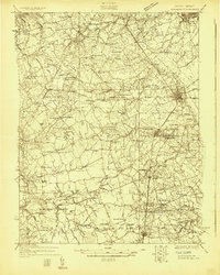
 1920 Dover1920 Print · USGSThe Maryland and Delaware borderlands at the end of the Great War reveal a landscape of tidewater landings and evolving rail lines. Trace family roots and vanished wharves through Fredericktown, the Mason and Dixon Line, and the Bombay Hook Light.
 - 1920 Map of Chestertown
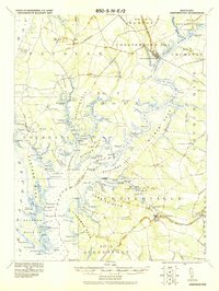 1920 Chestertown1920 Print · USGSThe Eastern Shore of Maryland in the early twentieth century reveals a world of steamships and shoreline industry. Trace old family landings and rail stops like Learys Mill Whf, Centerville Ldg, and the Maryland and Delaware RR.
 - 1926 Map of Wyoming
 1926 Wyoming1926 Print · USGSCentral Delaware in the mid-twenties shows a landscape defined by the Pennsylvania RR and a dense network of rural schoolhouses. Researchers can locate family landmarks at Wrights Crossroads, Voshell Mill, or the many parish sites like Bryn Zion Church.
End of results
Showing maps 1-3 of 3
Top cities of Queen Anne's County
- Stevensville historical maps
- Centreville historical maps
- Chester historical maps
- Grasonville historical maps
- Kingstown historical maps
- Queenstown historical maps
See more
Frequently asked questions
- What are the different types of historical maps available for Queen Anne's County?
- What is the oldest map of Queen Anne's County?
- Where can I purchase historical maps of Queen Anne's County for my home or office?
- Where can I download high-res historical maps of Queen Anne's County?
- Are there historical topographic maps available for Queen Anne's County?
- Is there historical aerial imagery available for Queen Anne's County?
- Where are historical maps of Queen Anne's County sourced from?