Old Maps of Queen Anne's County, Maryland for Metal Detecting
Plan your next treasure hunt with 183 historic maps of Queen Anne's County. Find old homesites, ghost towns, trails, and gathering spots that may be lost to time — perfect for identifying promising metal detecting locations.
- Locate forgotten sites: Uncover places like long-lost settlements, abandoned rail lines, or gathering spots.
- Plan better hunts: Use map overlays combined with LiDAR or satellite views to narrow in on historically rich areas.
- Made for detectorists: Thousands of hobbyists use these maps to discover relics, coins, and hidden history.
Use these historic maps to boost your research and find new opportunities beneath the surface of Queen Anne's County.
Queen Anne's County, MD maps
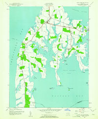
(183)- 1892 Map of Annapolis
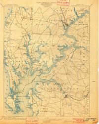
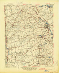
 1892 Annapolis1892 Print · USGSMaryland's capital and the surrounding Chesapeake Bay shores appear here during the late Victorian era, before modern bridges linked the coastlines. Genealogists can trace early homesteads and rail lines in Annapolis or explore eastern shore landings like Claiborne and Kent Island.2 unique versions available
 - 1893 Map of North Point
 1893 North Point1893 Print · USGSMaryland's maritime heart is captured here in the late nineteenth century, showing the industrial rise of Steelton and the rural reaches of Anne Arundel. Researchers can trace old landings and light stations like Wilson Wharf, Sandy Pt. Light, and the settlement at Jacob Store.3 unique versions available
 - 1898 Map of Choptank
 1898 Choptank1898 Print · USGSThe Maryland Eastern Shore and its intricate Chesapeake coastline are documented here in the late 1890s. Genealogists can trace family roots in Annapolis or Easton, while maritime historians can locate historic landings such as Corners Wharf and Wye Landing.2 unique versions available
 - 1898 Map of Tolchester
 1898 Tolchester1898 Print · USGSThe upper Chesapeake Bay and its tidal tributaries are shown in the late 1890s, when steamships and railroads still dominated regional commerce. Trace the landings and rail stops that fueled the bay economy, from Buck Neck Landing to Stillpond Sta. and the historic Harford Furnace.
 - 1899 Map of Dover
 1899 Dover1899 Print · USGSDelaware and Maryland river country thrived in the late nineteenth century as a network of landings and rail lines. Trace old wharves at Cassidy Ldg., explore the area around Bohemia Mills, or locate maritime landmarks like Bombay Hook Light.2 unique versions available
 - 1900 Map of Cecilton
 1900 Cecilton1900 Print · USGSUpper Chesapeake life at the turn of the century was defined by the deep tidal necks of the Sassafras River. You can trace old steamboat landings like Wilson Point Whf. and rural rail stops along the Baltimore and Delaware Bay R. R.6 unique versions available
 - 1901 Map of Chestertown
 1901 Chestertown1901 Print · USGSThe Eastern Shore of Maryland comes alive in this turn-of-the-century survey of the Chester River and its surrounding necks. Genealogists and historians can trace the early rail lines and numerous river landings like Spaniards Landing, Tolchester Beach, and Leary's Mill Whf.4 unique versions available
 - 1903 Map of Tolchester
 1903 Tolchester1903 Print · USGSThe upper Chesapeake Bay at the turn of the century shows a bustling maritime landscape where steamship wharves and major rail lines met. Researchers can trace defunct stops like Baldwin Sta. and Clayton Sta. or locate historic landings such as Rockhall Landing and Quaker Wharf.
 - 1904 Map of St. Michaels
 1904 St. Michaels1904 Print · USGSThe Eastern Shore’s tidewater landscape at the start of the twentieth century is defined by its deep estuaries and thriving river towns. Genealogists and historians can trace the old rail lines of the Baltimore and Eastern Shore RR and locate historic landings like Probasco Landing and Skipton Landing.3 unique versions available
 - 1904 Map of North Point
 1904 North Point1904 Print · USGSChesapeake Bay maritime life at the turn of the century is captured here, from industrial waterfronts to rural landings. Genealogists can trace family landmarks and ferry points like Love Point Landing, Sparrow Point, and Skidmore.5 unique versions available
 - 1904 Map of Annapolis
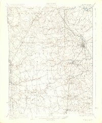
 1904 Annapolis1904 Print · USGSMaryland's capital and the Eastern Shore are captured in detail just after the turn of the century. Genealogists and maritime historians can trace property near Annapolis, the grounds of the U. S. Naval Academy, and remote settlements like Stevensville on Kent Island.5 unique versions available
 - 1905 Map of Denton
 1905 Denton1905 Print · USGSMaryland's Eastern Shore appears at the height of its riverboat and rail era, centered on the Choptank River. Genealogists and historians can trace the Steamboat Route to Wayman Wharf or locate old community hubs like American Corners and the Laurel Grove Church.3 unique versions available
 - 1905 Map of Barclay
 1905 Barclay1905 Print · USGSUpper Delmarva at the start of the twentieth century was a landscape of rail-connected farming towns and river landings. Trace family roots and old property lines near Sudlersville, the Ashland Hayden P O, and the Benedictine Convent.3 unique versions available
 - 1906 Map of Dover
 1906 Dover1906 Print · USGSCentral Delaware and Maryland's Eastern Shore appear at the start of the twentieth century, focused on the bustling rail-and-river economy. Genealogists can trace old family landing sites and crossroads villages like Bohemia Mills, Deakyneville Ldg., and Seven Hickories.3 unique versions available
 - 1908 Map of Tolchester
 1908 Tolchester1908 Print · USGSChesapeake Bay life at the turn of the century centered on a complex network of tidewater landings and strategic railroad lines. Researchers can trace historic family settlements and maritime landmarks like Fort Howard, Harford Furnace, and the Sevenfoot Knoll LH.4 unique versions available
 - 1908 Map of Choptank
 1908 Choptank1908 Print · USGSMaryland's Eastern Shore and the Chesapeake Bay are captured here at the start of the twentieth century, showing a world of steamships and rail. Genealogists can trace family names at St Michaels, Oxford, and waterfront landings like Claiborne or Arundel on the Bay.5 unique versions available
 - 1920 Map of Dover
 1920 Dover1920 Print · USGSThe Maryland and Delaware borderlands at the end of the Great War reveal a landscape of tidewater landings and evolving rail lines. Trace family roots and vanished wharves through Fredericktown, the Mason and Dixon Line, and the Bombay Hook Light.
 - 1920 Map of Chestertown
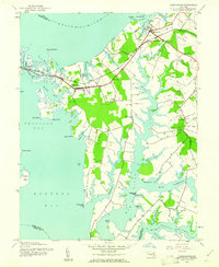
 1920 Chestertown1920 Print · USGSThe Eastern Shore of Maryland in the early twentieth century reveals a world of steamships and shoreline industry. Trace old family landings and rail stops like Learys Mill Whf, Centerville Ldg, and the Maryland and Delaware RR.
 - 1926 Map of Wyoming
 1926 Wyoming1926 Print · USGSCentral Delaware in the mid-twenties shows a landscape defined by the Pennsylvania RR and a dense network of rural schoolhouses. Researchers can locate family landmarks at Wrights Crossroads, Voshell Mill, or the many parish sites like Bryn Zion Church.
 - 1930 Map of Wyoming, 1945 Print
 1930 Wyoming1945 Print · USGSCentral Delaware in the mid-1920s reveals a structured landscape of rural school districts and railroad-connected towns surrounding the capital. Genealogists and historians can trace family locations near landmarks like Voshell Mill, the County Poor Farm, or many rural schoolhouses like Lockwood Sch.
 - 1931 Map of Wyoming
 1931 Wyoming1931 Print · USGSKent County and the Maryland borderlands are seen here between the world wars, a landscape of rail-connected towns and rural districts. Genealogists can trace family lines through numerous sites like Dinaus Corner, the County Poor Farm, and Bethel church.2 unique versions available
 - 1942 Map of Love Point
 1942 Love Point1942 Print · USGSNorthern Kent Island served as a vital Chesapeake transit hub during the early forties. Trace the rail-to-ferry connection at Love Point Landing and locate landmarks like the Love Point Lighthouse and Cupola Barn.
 - 1942 Map of Claiborne, 1961 Print
 1942 Claiborne1961 Print · USGSCoastal Talbot County is captured here in the early 1940s, featuring the busy rail-to-ferry connection at Claiborne. Genealogists and historians can trace family locations near McDaniel and Bozman, or locate local landmarks like St Johns Ch and Wittman Sch.4 unique versions available
 - 1942 Map of Kent Island, 1961 Print
 1942 Kent Island1961 Print · USGSKent Island at the onset of the 1940s remained a landscape of ferry landings and rail terminals along the Chesapeake. Genealogists and local historians can trace family locations near Batts Neck Sch, Stevensville, and the Baltimore and Eastern RR line.3 unique versions available
 - 1942 Map of Queenstown, 1961 Print
 1942 Queenstown1961 Print · USGSMaryland's Eastern Shore at the start of the 1940s reveals a landscape shaped by tidal creeks and the rail-and-water economy. Genealogists can trace family footprints near St Peters Ch, Grasonville Cem, and the historic waterfront of Queenstown.3 unique versions available
Showing maps 1-25 of 183
Top cities of Queen Anne's County
- Stevensville historical maps
- Centreville historical maps
- Chester historical maps
- Grasonville historical maps
- Kingstown historical maps
- Queenstown historical maps
See more
Frequently asked questions
- What are the different types of historical maps available for Queen Anne's County?
- What is the oldest map of Queen Anne's County?
- Where can I purchase historical maps of Queen Anne's County for my home or office?
- Where can I download high-res historical maps of Queen Anne's County?
- Are there historical topographic maps available for Queen Anne's County?
- Is there historical aerial imagery available for Queen Anne's County?
- Where are historical maps of Queen Anne's County sourced from?