1970s Maps of Wicomico County, Maryland
Explore 3 historic maps of Wicomico County from the 1970s. These maps offer a rare glimpse into what life looked like during the 1970s — showing old roads, neighborhoods, homes, and landmarks that have changed or disappeared over time.
Whether you're researching your family's past, planning a metal detecting trip, or studying how Wicomico County's landscape evolved across the 1970s, these high-resolution maps are a powerful tool for exploring the history of this region.
- Focus on a specific era: All maps on this page are from the 1970s, giving you a focused view of this time period.
- See what’s changed: Compare century-old streets, trails, and buildings to today's modern landscape using overlays and satellite layers.
- Research with precision: Use these maps for genealogy, historical research, land use analysis, or educational projects.
- View, download, or print: Maps are fully viewable online in high resolution, and can be downloaded or printed for your own records.
Start exploring Wicomico County's history through authentic maps from the 1970s. This is your window into the past.
Wicomico County, MD maps
(3)- 1971 Map of Delmar
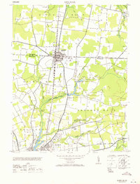 1971 Delmar1971 Print · USGSThe border town of Delmar and northern Salisbury appear here during the mid-twentieth century as rail and air transport reshaped the Delmarva landscape. Trace the Pennsylvania railroad line, the Salisbury Airport, and the Charity church.
 - 1972 Map of Deal Island, 1974 Print
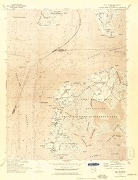 1972 Deal Island1974 Print · USGSThe Eastern Shore of Maryland in the early seventies reveals a landscape defined by tide and timber. Trace the water-based communities of Wenona, Chance, and Dames Quarter or locate family landmarks like Somerset Ch and St Pauls Ch among the marshes.2 unique versions available
 - 1972 Map of Monie, 1975 Print
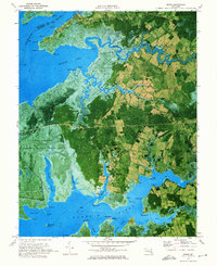 1972 Monie1975 Print · USGSSomerset County's tidal marshes and small coastal hamlets are frozen in time during the early seventies. Genealogists and local historians can trace family roots through the many small churches and roads like St James Ch, Oriole Cem, and Millard Long Road.2 unique versions available
End of results
Showing maps 1-3 of 3
Top cities of Wicomico County
- Salisbury historical maps
- Fruitland historical maps
- Pittsville historical maps
- Hebron historical maps
- Willards historical maps
- Sharptown historical maps
See more
Frequently asked questions
- What are the different types of historical maps available for Wicomico County?
- What is the oldest map of Wicomico County?
- Where can I purchase historical maps of Wicomico County for my home or office?
- Where can I download high-res historical maps of Wicomico County?
- Are there historical topographic maps available for Wicomico County?
- Is there historical aerial imagery available for Wicomico County?
- Where are historical maps of Wicomico County sourced from?