Old Maps of Wicomico County, Maryland for Hiking & Exploration
Hike through history with 136 historic maps of Wicomico County. Explore old trails, ghost towns, and forgotten backroads — perfect for outdoor adventurers and local explorers.
- Rediscover forgotten places: Map out old mining camps, roads, and footpaths that no longer exist on modern maps.
- Layer with modern tools: Combine with LiDAR or satellite views to plan hikes through historical terrain.
- Made for exploration: Popular among hikers, overlanders, and local history lovers.
Use these maps to find adventure and explore the hidden past of Wicomico County.
Wicomico County, MD maps
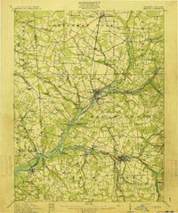
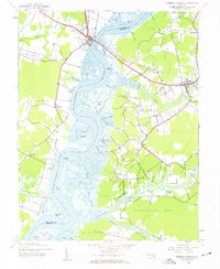
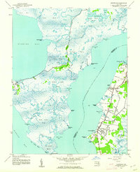
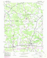
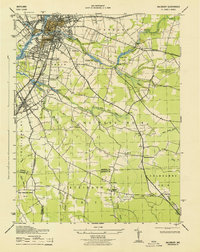
(136)- 1901 Map of Salisbury
 1901 Salisbury1901 Print · USGSWicomico County at the turn of the century centered on the steamboat and rail traffic through Salisbury. Trace historic family-named locations and rural infrastructure like Fooks School, Minksville, and the steam route at Shad Pt.4 unique versions available
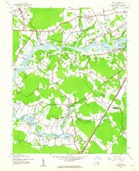
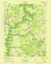
 - 1902 Map of Pittsville
 1902 Pittsville1902 Print · USGSEastern Shore life at the turn of the century is centered on the Baltimore Chesapeake and Atlantic rail line and the Pocomoke River. Genealogists can locate family-named sites like Tilghman Pond and Hearns or trace the old rail stop at Ironshire Station.4 unique versions available
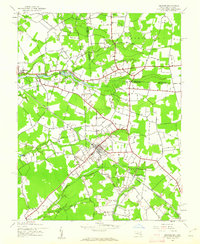
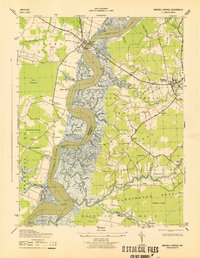
 - 1903 Map of Nanticoke
 1903 Nanticoke1903 Print · USGSThe Nanticoke River and Fishing Bay define this era of Eastern Shore life at the opening of the twentieth century. Genealogists can trace family names at waterfront landings like Lewis Ldg. or find early rail connections at Vienna and Mardela Springs.4 unique versions available
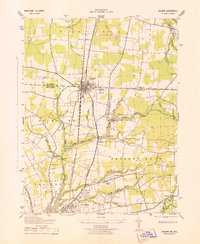
 - 1903 Map of Deal Island
 1903 Deal Island1903 Print · USGSSomerset County's coastal marshes and island communities come to life in this turn-of-the-century survey of the Chesapeake. Genealogists and maritime historians can trace family locations from DEAL ISLAND to Upper Fairmount, and locate early navigation aids like Great Shoals L.H. or the rail terminus at Hopewell.3 unique versions available
 - 1905 Map of Hurlock
 1905 Hurlock1905 Print · USGSDorchester and Caroline Counties thrive on a river-and-rail economy at the turn of the century. Genealogists can trace family roots through landings and crossings like Tennalls Wharf, Harrison Ferry, and the junction at Hurlock.3 unique versions available
 - 1915 Map of Seaford
 1915 Seaford1915 Print · USGSCoastal Sussex County and the Maryland borderlands are seen here at a time when river traffic and rail lines were the lifeblood of the region. Researchers can trace the Steamboat Route up to Seaford or locate ancestral sites like Cannons Ferry and Cokesbury School.4 unique versions available
 - 1942 Map of Deal Island, 1958 Print
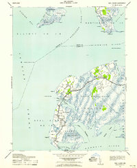 1942 Deal Island1958 Print · USGSCoastal Somerset County is shown here in the early 1940s, a landscape of isolated fishing villages and vital Chesapeake Bay navigation aids. Researchers can trace the waterfront settlements of Wenona, Chance, and Deal Island or locate maritime landmarks like Haines Point Light.2 unique versions available
 - 1942 Map of Monie, 1958 Print
 1942 Monie1958 Print · USGSCoastal Somerset County in the early 1940s is a landscape of expansive tidal marshes and isolated necks. Genealogists can trace family footprints through the dispersed communities of Oriole, Venton, and Champ, or locate rural landmarks like St Peters ME Church.
 - 1942 Map of Wetipquin, 1962 Print
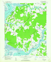 1942 Wetipquin1962 Print · USGSCoastal Wicomico County comes to life in this mid-century survey of the river necks and marshlands along the Nanticoke. Genealogists can trace family roots through landings and local landmarks like Whitehaven, St Marys Ch, and the Wetipquin Ferry.
 - 1942 Map of Ninepin, 1962 Print
 1942 Ninepin1962 Print · USGSThe lowlands of Maryland's Eastern Shore are captured in the early 1940s, highlighting a landscape of extensive wetlands and drainage ditches. Researchers can trace rail-era sites like Ironshire Sta and local gathering spots such as Mt Pleasant Ch and Adkins Pond.
 - 1942 Map of Mardela Springs, 1962 Print
 1942 Mardela Springs1962 Print · USGSMaryland's Eastern Shore during the early 1940s reveals a world of river-oriented necks and tidal marshlands. Genealogists can trace small settlements and river landings like Rabbit Town, Cherrywalk, and Jenkins Landing along the Nanticoke River.2 unique versions available
 - 1942 Map of Eden, 1962 Print
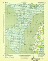
 1942 Eden1962 Print · USGSThe Wicomico River dominates this wartime survey of the Maryland coast, showing the rural landscapes of Somerset and Wicomico Counties. Genealogists can trace family connections through riverfront landmarks like Wagner Landing, the remote Catchpenny settlement, and the Pine Bluff Sanitarium.2 unique versions available
 - 1942 Map of Wango, 1962 Print
 1942 Wango1962 Print · USGSThe Wicomico and Worcester County line ran through a landscape of managed wetlands and experimental timber lands during the early 1940s. Genealogists and historians can trace rural life through sites like Powellville, St Johns Cem, and Mt Zion Ch.
 - 1942 Map of Hebron, 1962 Print
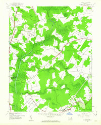
 1942 Hebron1962 Print · USGSThe rural Wicomico County landscape at the start of the 1940s shows a region defined by its creek-fed ponds and rail connections. Researchers can trace the Baltimore and Eastern tracks through Hebron or locate early sites like Spring Hill Airport and Porter Mill Creek.2 unique versions available
 - 1942 Map of Nanticoke, 1962 Print
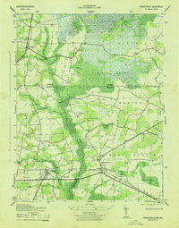
 1942 Nanticoke1962 Print · USGSThe Chesapeake Bay shoreline in the early 1940s reveals a world of remote fishing villages and vast tidal marshes. You can trace the maritime layout of Nanticoke, Bivalve, and Elliott, or locate family landmarks like Ryles Hill and Nanticoke Wharf.
 - 1942 Map of Whaleysville, 1962 Print
 1942 Whaleysville1962 Print · USGSThe Maryland and Delaware borderlands were defined by the rail-and-water economy during the early 1940s. Genealogists and local historians can trace the foundations of communities like Whaleysville and Willards, along with rural landmarks like Pulletts Chapel and Newhope Cem.3 unique versions available
 - 1942 Map of Salisbury, 1962 Print
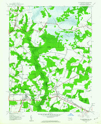
 1942 Salisbury1962 Print · USGSMaryland's Eastern Shore hub of Salisbury and the nearby settlement of Fruitland are seen here in the early 1940s. Genealogists and historians can trace rail routes like the Pennsylvania RR and find rural landmarks like St Lukes Ch and the Wicomico Orphanage.2 unique versions available
 - 1942 Map of Delmar, 1983 Print
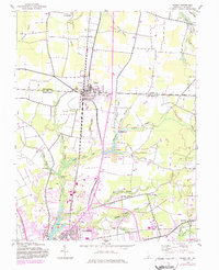 1942 Delmar1983 Print · USGSThe border community of Delmar is shown during its mid-century development as a rail and highway hub on the Delaware-Maryland line. Genealogists and local historians can trace family locations near St George, the Charity church, and the Wicomico River headwaters.
 - 1942 Map of Pittsville, 1983 Print
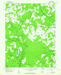
 1942 Pittsville1983 Print · USGSThe Maryland-Delaware borderlands are captured here in the early 1940s, showing a landscape defined by crossroads communities and extensive drainage works. Researchers can trace family-named sites like Glass Hill or locate the community life centered at Line Church and Pittsville.
 - 1943 Map of Ninepin
 1943 Ninepin1943 Print · USGSWorcester County is characterized by its vast swamp systems and small rail-side hamlets in the years following the Great Depression. Genealogists and local historians can trace family locations near Mt Pleasant Church or follow the old Pennsylvania Railroad line through Queponco Sta and Newark.
 - 1943 Map of Mardela Springs
 1943 Mardela Springs1943 Print · USGSMaryland's Eastern Shore landscape is captured here in the early 1940s, where the winding Nanticoke River connects rural river towns and crossroads. Researchers can locate early landing sites and farmsteads at Ferry Pt, Rabbit Town, and Camphels Whf.
 - 1943 Map of Delmar
 1943 Delmar1943 Print · USGSThe Maryland-Delaware border region comes alive in this wartime survey of the rail and water networks connecting the two states. Genealogists can trace family locations near the State Game Farm or the rural settlements of Charity and Five Points.
 - 1943 Map of Salisbury
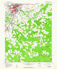
 1943 Salisbury1943 Print · USGSWicomico County at the height of the war years reveals a bustling Salisbury and the surrounding agricultural tidewater districts. Researchers can trace historic family properties near Nassawango Church, Mt Hermon, and along the Pennsylvania Railroad corridor.
 - 1943 Map of Nanticoke
 1943 Nanticoke1943 Print · USGSChesapeake maritime life in the early 1940s is centered here along the Nanticoke River and its surrounding wetlands. Genealogists and historians can trace the waterfront settlements of NANTICOKE and Bivalve, or locate the historic crossings of the Tyaskin Ferry.
 - 1943 Map of Whaleysville
 1943 Whaleysville1943 Print · USGSThe Maryland-Delaware border region in the early 1940s was a landscape defined by the drainage of the Cypress Swamp and the Pocomoke River. Researchers can locate historic rural landmarks including Pilgrim Church, Pulletts Chapel, and the Newhope Cem.
Showing maps 1-25 of 136
Top cities of Wicomico County
- Salisbury historical maps
- Fruitland historical maps
- Pittsville historical maps
- Hebron historical maps
- Willards historical maps
- Sharptown historical maps
See more
Frequently asked questions
- What are the different types of historical maps available for Wicomico County?
- What is the oldest map of Wicomico County?
- Where can I purchase historical maps of Wicomico County for my home or office?
- Where can I download high-res historical maps of Wicomico County?
- Are there historical topographic maps available for Wicomico County?
- Is there historical aerial imagery available for Wicomico County?
- Where are historical maps of Wicomico County sourced from?