1990s Maps of Wicomico County, Maryland
Explore 5 historic maps of Wicomico County from the 1990s. These maps offer a rare glimpse into what life looked like during the 1990s — showing old roads, neighborhoods, homes, and landmarks that have changed or disappeared over time.
Whether you're researching your family's past, planning a metal detecting trip, or studying how Wicomico County's landscape evolved across the 1990s, these high-resolution maps are a powerful tool for exploring the history of this region.
- Focus on a specific era: All maps on this page are from the 1990s, giving you a focused view of this time period.
- See what’s changed: Compare century-old streets, trails, and buildings to today's modern landscape using overlays and satellite layers.
- Research with precision: Use these maps for genealogy, historical research, land use analysis, or educational projects.
- View, download, or print: Maps are fully viewable online in high resolution, and can be downloaded or printed for your own records.
Start exploring Wicomico County's history through authentic maps from the 1990s. This is your window into the past.
Wicomico County, MD maps
(5)- 1992 Map of Hebron
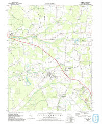 1992 Hebron1992 Print · USGSThe Maryland-Delaware border region comes alive in this early 1990s survey of Wicomico County. Genealogists and historians can trace the foundations of Hebron, locate family sites near St Pauls Church, and follow the path of the Old Railroad.
 - 1992 Map of Pittsville
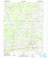 1992 Pittsville1992 Print · USGSMaryland's borderlands with Delaware come into focus in the early 1990s, centered on the growing rail and road hubs of Wicomico County. Genealogists and historians can trace community roots through rural sites like Melson Ch, Aydelotte, and the remote Race Bridge Cem.
 - 1992 Map of Whaleysville
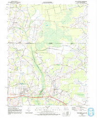 1992 Whaleysville1992 Print · USGSThe Maryland-Delaware borderlands appear in the early nineties as a landscape of swamp-fringed settlements and agricultural ridges. Genealogists can trace family names and local landmarks through Pulletts Chapel, the Willards Sch, and the Bethel Cem near Gumboro.
 - 1992 Map of Delmar
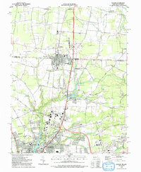 1992 Delmar1992 Print · USGSSpanning the border between Delaware and Maryland in the 1990s, this area shows the rail-centered growth of Delmar and the expanding suburbs of Salisbury. Genealogists can trace family names through Oliphant Cem and Nichols Cem or locate historic sites like Leonards Mill.
 - 1992 Map of Sharptown
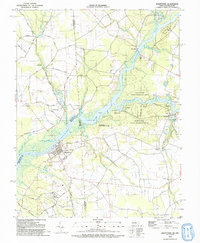 1992 Sharptown1992 Print · USGSThe Nanticoke River valley on the Maryland-Delaware border is captured here in the 1990s as a landscape of river landings and rural crossroads. Researchers can trace family history through sites like Santa Domingo, Zion Ch, and the Redman Cem.
End of results
Showing maps 1-5 of 5
Top cities of Wicomico County
- Salisbury historical maps
- Fruitland historical maps
- Pittsville historical maps
- Hebron historical maps
- Willards historical maps
- Sharptown historical maps
See more
Frequently asked questions
- What are the different types of historical maps available for Wicomico County?
- What is the oldest map of Wicomico County?
- Where can I purchase historical maps of Wicomico County for my home or office?
- Where can I download high-res historical maps of Wicomico County?
- Are there historical topographic maps available for Wicomico County?
- Is there historical aerial imagery available for Wicomico County?
- Where are historical maps of Wicomico County sourced from?