1980s Maps of Wicomico County, Maryland
Explore 10 historic maps of Wicomico County from the 1980s. These maps offer a rare glimpse into what life looked like during the 1980s — showing old roads, neighborhoods, homes, and landmarks that have changed or disappeared over time.
Whether you're researching your family's past, planning a metal detecting trip, or studying how Wicomico County's landscape evolved across the 1980s, these high-resolution maps are a powerful tool for exploring the history of this region.
- Focus on a specific era: All maps on this page are from the 1980s, giving you a focused view of this time period.
- See what’s changed: Compare century-old streets, trails, and buildings to today's modern landscape using overlays and satellite layers.
- Research with precision: Use these maps for genealogy, historical research, land use analysis, or educational projects.
- View, download, or print: Maps are fully viewable online in high resolution, and can be downloaded or printed for your own records.
Start exploring Wicomico County's history through authentic maps from the 1980s. This is your window into the past.
Wicomico County, MD maps
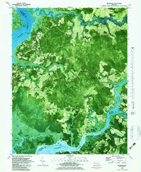
(10)- 1982 Map of Wango, 1983 Print
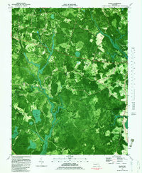 1982 Wango1983 Print · USGSWicomico County in the late 1970s is characterized by dense state forests and the intricate drainage of the Nassawango watershed. Genealogists can trace family landmarks like St Johns Ch and Friendship Ch or find old roads near Wango and Powellville.2 unique versions available
 - 1982 Map of Salisbury, 1983 Print
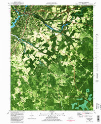 1982 Salisbury1983 Print · USGSThe Lower Eastern Shore enters the early eighties with Salisbury at its heart, showing a mix of college-town growth and rural timberlands. Trace the local landscape from Salisbury State College to the quiet reaches of the Pocomoke State Forest.2 unique versions available
 - 1982 Map of Mardela Springs, 1983 Print
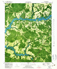
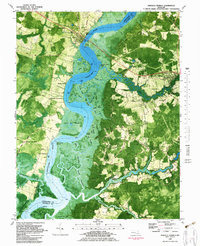 1982 Mardela Springs1983 Print · USGSThe Eastern Shore's riverine culture is on full display in the early 1980s as the Nanticoke River winds through the Maryland marshlands. Genealogists and historians can trace the rural landscape from Mardela Springs to small settlements like Athol and Rewastico.
 - 1982 Map of Ninepin Branch, 1983 Print
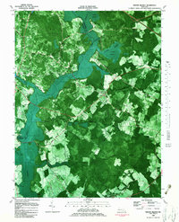 1982 Ninepin Branch1983 Print · USGSWorcester County remained a landscape of wetlands and small farming settlements in the early eighties. Researchers can trace the Conrail line to Ironshire Sta or locate rural landmarks like Mt Pleasant Ch and Adkins Pond.
 - 1983 Map of Wetipquin
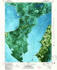
 1983 Wetipquin1983 Print · USGSThe Eastern Shore's river-driven geography is on full display here in the early 1980s. Genealogists and local historians can locate rural landmarks such as Whitehaven, Capitola, and the White Haven Church alongside the tidal reaches of the Wicomico River.
 - 1983 Map of Nanticoke
 1983 Nanticoke1983 Print · USGSThe marshes and maritime villages of the Chesapeake Bay's eastern shore are captured here in the early eighties. Researchers can trace land holdings and community sites near Nanticoke, the remote Elliott Island, and local landmarks like Elzey Ch and Roaring Point.
 - 1983 Map of Eden
 1983 Eden1983 Print · USGSThe Wicomico River waterfront and rural Somerset County are captured in the early eighties, showing a landscape defined by tidal creeks and river landings. Genealogists can trace family-named sites like Harcums Wharf and Twiggs Corner, or locate rural churches including Holy Temple Ch.
 - 1983 Map of Salisbury, 1984 Print
 1983 Salisbury1984 Print · USGSThe Lower Eastern Shore was a landscape of tide and timber in the early eighties, from the bustling streets of Salisbury to the wild coast of Assateague Island. Researchers can trace the rail-and-road network of the Conrail and U S Highway 50 while locating historic centers like Princess Anne and Crisfield.
 - 1984 Map of Seaford, 1986 Print
 1984 Seaford1986 Print · USGSCoastal Delaware and the Maryland borderlands are captured here in the mid-eighties as modern tourism and traditional agriculture coexist. Researchers can trace the rail-and-river routes through Seaford, explore inland millponds like Chipman Pond, or study the shoreline at Cape Henlopen.2 unique versions available
 - 1988 Map of Rhodesdale
 1988 Rhodesdale1988 Print · USGSDorchester County's rural landscape is captured in the late eighties as it straddles the river-fed borders of the Eastern Shore. Genealogists and historians can trace family locations through McKendree Cem, the landing at Riverton, and agricultural settlements like Reids Grove.
End of results
Showing maps 1-10 of 10
Top cities of Wicomico County
- Salisbury historical maps
- Fruitland historical maps
- Pittsville historical maps
- Hebron historical maps
- Willards historical maps
- Sharptown historical maps
See more
Frequently asked questions
- What are the different types of historical maps available for Wicomico County?
- What is the oldest map of Wicomico County?
- Where can I purchase historical maps of Wicomico County for my home or office?
- Where can I download high-res historical maps of Wicomico County?
- Are there historical topographic maps available for Wicomico County?
- Is there historical aerial imagery available for Wicomico County?
- Where are historical maps of Wicomico County sourced from?