1890s Maps of Barnstable County, Massachusetts
Explore 9 historic maps of Barnstable County from the 1890s. These maps offer a rare glimpse into what life looked like during the 1890s — showing old roads, neighborhoods, homes, and landmarks that have changed or disappeared over time.
Whether you're researching your family's past, planning a metal detecting trip, or studying how Barnstable County's landscape evolved across the 1890s, these high-resolution maps are a powerful tool for exploring the history of this region.
- Focus on a specific era: All maps on this page are from the 1890s, giving you a focused view of this time period.
- See what’s changed: Compare century-old streets, trails, and buildings to today's modern landscape using overlays and satellite layers.
- Research with precision: Use these maps for genealogy, historical research, land use analysis, or educational projects.
- View, download, or print: Maps are fully viewable online in high resolution, and can be downloaded or printed for your own records.
Start exploring Barnstable County's history through authentic maps from the 1890s. This is your window into the past.
Barnstable County, MA maps
(9)- 1893 Map of Chatham
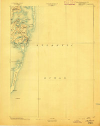 1893 Chatham1893 Print · USGSThe outer Cape Cod coastline at the end of the nineteenth century reveals a complex maritime landscape of barrier islands and shifting shoals. Trace the old village footprints of Chatham and North Chatham alongside vital coastal aids like Chatham Lights and the Pollock Rip Light Ship.7 unique versions available
 - 1893 Map of Yarmouth
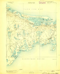
 1893 Yarmouth1893 Print · USGSMid-Cape Cod in the late nineteenth century is a landscape of thriving maritime villages and a busy rail network. Trace nineteenth-century family roots across Old Colony Railroad depots and through settlements like South Yarmouth, Dennis Port, and West Brewster.7 unique versions available
 - 1893 Map of Wellfleet
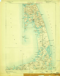 1893 Wellfleet1893 Print · USGSCape Cod's outer reaches are shown in the late 1800s, when the Old Colony Railroad served isolated fishing villages and lifesaving stations. Trace historic sites like the Methodist Camp Ground, Billingsgate Light, and early schools at Schoolhouse Pond.8 unique versions available
 - 1893 Map of Barnstable
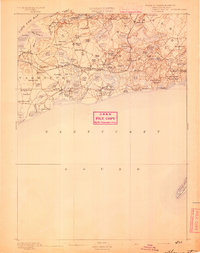
 1893 Barnstable1893 Print · USGSCape Cod in the late nineteenth century remains a landscape of maritime navigation and early rail travel. Genealogists can trace family roots through sites like the Indian Meeting House, the Yarmouth Camp Grounds, and the Spring Hill Academy.8 unique versions available
 - 1893 Map of Falmouth
 1893 Falmouth1893 Print · USGSCape Cod's western shore and the upper reaches of Buzzards Bay are captured here in the late nineteenth century as rail travel transformed the coast. Genealogists can trace family names at Waquoit Village or follow the Old Colony Railroad through Woods Holl and Falmouth Station.9 unique versions available
 - 1893 Map of New Bedford
 1893 New Bedford1893 Print · USGSThe South Coast of Massachusetts is captured here in the late nineteenth century as a hub of maritime trade and rail transit. Researchers can trace the waterfront development of New Bedford, find old coastal lights like Neds Point Light, and locate family settlements at Potomska and Apponagansett.9 unique versions available
 - 1894 Map of Plymouth
 1894 Plymouth1894 Print · USGSCoastal Massachusetts at the end of the nineteenth century reveals a landscape of maritime commerce and kettle ponds. Trace the rail lines of the Old Colony Railroad and find early village sites like Wellingsly, Chiltonville, and Bournedale.9 unique versions available
 - 1894 Map of Marthas Vineyard, 1898 Print
 1894 Marthas Vineyard1898 Print · USGSMartha's Vineyard in the 1890s appears as a land of maritime necessity and early coastal villages. Genealogists can trace family settlements in Vineyard Haven and Edgartown or locate lighthouses like West Chop Light and Cape Poge Light.7 unique versions available
 - 1898 Map of Provincetown, 1940 Print
 1898 Provincetown1940 Print · USGSCoastal Massachusetts in the late nineteenth century comes to life through this detailed look at the outer Cape. Genealogists and maritime historians can trace a network of early federal outposts like Highland Life Saving Station and beacons such as Long Point Light.
End of results
Showing maps 1-9 of 9
Top cities of Barnstable County
- Falmouth historical maps
- Yarmouth historical maps
- Sandwich historical maps
- Bourne historical maps
- Dennis historical maps
- Mashpee historical maps
See more
Frequently asked questions
- What are the different types of historical maps available for Barnstable County?
- What is the oldest map of Barnstable County?
- Where can I purchase historical maps of Barnstable County for my home or office?
- Where can I download high-res historical maps of Barnstable County?
- Are there historical topographic maps available for Barnstable County?
- Is there historical aerial imagery available for Barnstable County?
- Where are historical maps of Barnstable County sourced from?