Old Maps of Barnstable County, Massachusetts for Metal Detecting
Plan your next treasure hunt with 311 historic maps of Barnstable County. Find old homesites, ghost towns, trails, and gathering spots that may be lost to time — perfect for identifying promising metal detecting locations.
- Locate forgotten sites: Uncover places like long-lost settlements, abandoned rail lines, or gathering spots.
- Plan better hunts: Use map overlays combined with LiDAR or satellite views to narrow in on historically rich areas.
- Made for detectorists: Thousands of hobbyists use these maps to discover relics, coins, and hidden history.
Use these historic maps to boost your research and find new opportunities beneath the surface of Barnstable County.
Barnstable County, MA maps
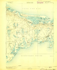
(311)- 1885 Map of New Bedford
 1885 New Bedford1885 Print · USGSThe Buzzards Bay coastline and its industrial hubs are captured here as the maritime economy met the rising age of rail. Genealogy and local history researchers can trace the streets of New Bedford, the tracks of the Old Colony Railroad, and coastal landmarks like Clark Point Light.
 - 1886 Map of Falmouth
 1886 Falmouth1886 Print · USGSThe Cape Cod peninsula during the late nineteenth century shows a landscape transitioning between maritime tradition and rail-driven growth. Genealogists can trace family footprints in Waquoit Village, Teaticket, and Menauhant while following the Old Colony Railroad corridor.
 - 1886 Map of Plymouth
 1886 Plymouth1886 Print · USGSThe South Shore and Cape Cod gateway appear here at a moment of transition during the late nineteenth century. Trace family roots and old rail lines through Chiltonville and Manomet, or follow the early footprint of the Cape Cod Canal.
 - 1887 Map of Wellfleet
 1887 Wellfleet1887 Print · USGSThe lower Cape comes into focus during the late nineteenth and early twentieth centuries as the railroad reshapes coastal commerce. Genealogists and historians can trace family locations near the Methodist Camp Ground, Mayo's Beach Light, and the Marconi Towers.
 - 1887 Map of Marthas Vineyard
 1887 Marthas Vineyard1887 Print · USGSMartha's Vineyard in the late nineteenth century remains a landscape of maritime commerce and quiet island life. Genealogists can trace family names and early settlements from Cottage City and Edgartown to the rural roads of West Tisbury.
 - 1887 Map of Yarmouth
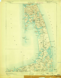
 1887 Yarmouth1887 Print · USGSMid-Cape Cod comes to life in the late nineteenth century as the rail network expands through established maritime villages. Genealogists can trace family footprints across South Yarmouth, West Dennis, and Harwich Port, or locate landmarks like Bass River Lt. and Scargo Hill.
 - 1887 Map of Provincetown
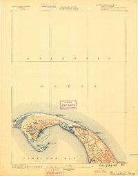
 1887 Provincetown1887 Print · USGSThe outer hook of Cape Cod appears here during the height of its maritime importance, featuring a critical network of lighthouses and life-saving stations. Genealogists and maritime historians can trace the early layout of Provincetown, the remote reaches of North Truro, and landmarks like Cape Cod Light.
 - 1888 Map of Barnstable
 1888 Barnstable1888 Print · USGSMid-Cape Cod in the late nineteenth century was defined by its maritime commerce and the arrival of the rail. Genealogists and historians can trace the foundations of local life at the Indian Meeting House, Marston's Mills, and the Old Colony Railroad.
 - 1888 Map of Chatham
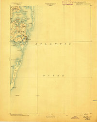
 1888 Chatham1888 Print · USGSThe Lower Cape Cod coastline appears in its late nineteenth-century form, from the settlements of Chatham and Orleans down the length of Monomoy Island. Maritime historians can trace essential safety landmarks like Chatham Lights and the Pollock Rip light ship.
 - 1888 Map of New Bedford
 1888 New Bedford1888 Print · USGSThe bustling whale oil and textile hub of New Bedford is shown here at its maritime peak in the late nineteenth century. Genealogists can trace early neighborhood grids and find outlying rural stops like Braleys Station, Turners Mills, and Nasketucket.
 - 1888 Map of Falmouth
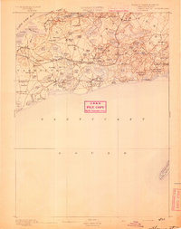
 1888 Falmouth1888 Print · USGSThe Buzzards Bay coastline and upper Cape Cod are captured here in the late nineteenth century, documenting the critical arrival of the railroad. Researchers can trace the Old Colony Railroad to its terminus at Woods Holl or locate maritime landmarks like Wing's Neck Light.
 - 1889 Map of Plymouth
 1889 Plymouth1889 Print · USGSCoastal Massachusetts at the close of the nineteenth century reveals a landscape of maritime trade and emerging rail corridors. Trace the historic routes of the Old Colony Railroad South Shore Branch and identify early settlement patterns in Plymouth, Chiltonville, and Wareham Centre.
 - 1889 Map of Yarmouth
 1889 Yarmouth1889 Print · USGSMid-Cape Cod comes to life in the late 1880s as the rail network reshapes the maritime landscape. Genealogists and historians can trace the early rail stops along the Old Colony Railroad and locate vanished landmarks like the Town House or the historic harbor at Dennis Port.
 - 1889 Map of Marthas Vineyard
 1889 Marthas Vineyard1889 Print · USGSThe eastern shores of the Vineyard come alive in the late Victorian era, showcasing the early growth of Cottage City and Edgartown. Genealogists and historians can trace old road networks connecting West Tisbury to the coast and locate historic beacons like West Chop Light.
 - 1889 Map of Provincetown
 1889 Provincetown1889 Print · USGSThe tip of Cape Cod is captured in the late nineteenth century as a critical maritime hub and life-saving corridor. Trace the early streets of Provincetown, the isolated Highland Light, and the vital Race Point Life Saving Station along the Atlantic shore.7 unique versions available
 - 1889 Map of Wellfleet
 1889 Wellfleet1889 Print · USGSThe Lower Cape is shown here in the late nineteenth century as a vital maritime and railroad corridor. Genealogists and historians can trace the early rail stops and shoreline landmarks like the Methodist Camp Ground and the Billingsgate Light.
 - 1893 Map of Chatham
 1893 Chatham1893 Print · USGSThe outer Cape Cod coastline at the end of the nineteenth century reveals a complex maritime landscape of barrier islands and shifting shoals. Trace the old village footprints of Chatham and North Chatham alongside vital coastal aids like Chatham Lights and the Pollock Rip Light Ship.7 unique versions available
 - 1893 Map of Yarmouth
 1893 Yarmouth1893 Print · USGSMid-Cape Cod in the late nineteenth century is a landscape of thriving maritime villages and a busy rail network. Trace nineteenth-century family roots across Old Colony Railroad depots and through settlements like South Yarmouth, Dennis Port, and West Brewster.7 unique versions available
 - 1893 Map of Wellfleet
 1893 Wellfleet1893 Print · USGSCape Cod's outer reaches are shown in the late 1800s, when the Old Colony Railroad served isolated fishing villages and lifesaving stations. Trace historic sites like the Methodist Camp Ground, Billingsgate Light, and early schools at Schoolhouse Pond.8 unique versions available
 - 1893 Map of Barnstable
 1893 Barnstable1893 Print · USGSCape Cod in the late nineteenth century remains a landscape of maritime navigation and early rail travel. Genealogists can trace family roots through sites like the Indian Meeting House, the Yarmouth Camp Grounds, and the Spring Hill Academy.8 unique versions available
 - 1893 Map of Falmouth
 1893 Falmouth1893 Print · USGSCape Cod's western shore and the upper reaches of Buzzards Bay are captured here in the late nineteenth century as rail travel transformed the coast. Genealogists can trace family names at Waquoit Village or follow the Old Colony Railroad through Woods Holl and Falmouth Station.9 unique versions available
 - 1893 Map of New Bedford
 1893 New Bedford1893 Print · USGSThe South Coast of Massachusetts is captured here in the late nineteenth century as a hub of maritime trade and rail transit. Researchers can trace the waterfront development of New Bedford, find old coastal lights like Neds Point Light, and locate family settlements at Potomska and Apponagansett.9 unique versions available
 - 1894 Map of Plymouth
 1894 Plymouth1894 Print · USGSCoastal Massachusetts at the end of the nineteenth century reveals a landscape of maritime commerce and kettle ponds. Trace the rail lines of the Old Colony Railroad and find early village sites like Wellingsly, Chiltonville, and Bournedale.9 unique versions available
 - 1894 Map of Marthas Vineyard, 1898 Print
 1894 Marthas Vineyard1898 Print · USGSMartha's Vineyard in the 1890s appears as a land of maritime necessity and early coastal villages. Genealogists can trace family settlements in Vineyard Haven and Edgartown or locate lighthouses like West Chop Light and Cape Poge Light.7 unique versions available
 - 1898 Map of Provincetown, 1940 Print
 1898 Provincetown1940 Print · USGSCoastal Massachusetts in the late nineteenth century comes to life through this detailed look at the outer Cape. Genealogists and maritime historians can trace a network of early federal outposts like Highland Life Saving Station and beacons such as Long Point Light.
Showing maps 1-25 of 311
Top cities of Barnstable County
- Falmouth historical maps
- Yarmouth historical maps
- Sandwich historical maps
- Bourne historical maps
- Dennis historical maps
- Mashpee historical maps
See more
Frequently asked questions
- What are the different types of historical maps available for Barnstable County?
- What is the oldest map of Barnstable County?
- Where can I purchase historical maps of Barnstable County for my home or office?
- Where can I download high-res historical maps of Barnstable County?
- Are there historical topographic maps available for Barnstable County?
- Is there historical aerial imagery available for Barnstable County?
- Where are historical maps of Barnstable County sourced from?