1930s Maps of Barnstable County, Massachusetts
Explore 9 historic maps of Barnstable County from the 1930s. These maps offer a rare glimpse into what life looked like during the 1930s — showing old roads, neighborhoods, homes, and landmarks that have changed or disappeared over time.
Whether you're researching your family's past, planning a metal detecting trip, or studying how Barnstable County's landscape evolved across the 1930s, these high-resolution maps are a powerful tool for exploring the history of this region.
- Focus on a specific era: All maps on this page are from the 1930s, giving you a focused view of this time period.
- See what’s changed: Compare century-old streets, trails, and buildings to today's modern landscape using overlays and satellite layers.
- Research with precision: Use these maps for genealogy, historical research, land use analysis, or educational projects.
- View, download, or print: Maps are fully viewable online in high resolution, and can be downloaded or printed for your own records.
Start exploring Barnstable County's history through authentic maps from the 1930s. This is your window into the past.
Barnstable County, MA maps
(9)- 1933 Map of Sagamore
 1933 Sagamore1933 Print · USGSThe Cape Cod shoreline and the recently completed canal define this area in the early 1930s. Researchers can trace the layout of coastal settlements like Sagamore Beach, locate the Indian Cem, and find industrial landmarks like Garland Bog.
 - 1935 Map of Wareham
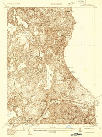
 1935 Wareham1935 Print · USGSThe cranberry bogs and rail corridors of Plymouth County are captured here in the mid-1930s before modern development altered the hydraulic landscape. Genealogists and historians can trace family-named sites and industrial markers such as Tihonet, the Center Cem, and the path of the New York New Haven and Hartford railroad.
 - 1935 Map of Pocasset
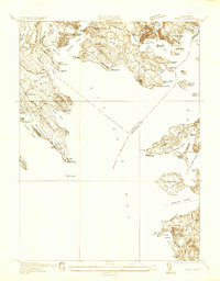
 1935 Pocasset1935 Print · USGSThe Upper Cape coast and its military transition are captured in the mid-1930s, showing the early layout of Camp Edwards. Trace the coastal rail line through Pocasset Sta or locate family landmarks like the Tobey Cem and the State Pier.
 - 1936 Map of Onset
 1936 Onset1936 Print · USGSCoastal Massachusetts at the height of the mid-thirties reveals a landscape of summer resorts and maritime life along Buzzards Bay. Genealogists and historians can trace old settlements like Onset or locate landmarks like Wings Neck Lighthouse and the Beverly Yacht Club.
 - 1936 Map of Falmouth
 1936 Falmouth1936 Print · USGSCoastal Barnstable County is documented here in the mid-1930s, showing the early layouts of seaside villages and their surrounding finger ponds. Genealogists and historians can trace the foundations of Falmouth Heights, Waquoit Village, and the Harbor Lighthouse.
 - 1936 Map of Woods Hole
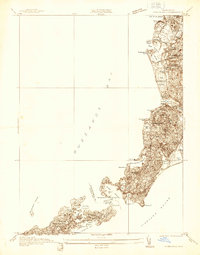 1936 Woods Hole1936 Print · USGSThe Elizabeth Islands and the Falmouth coast are captured here in the mid-1930s, showing the maritime heart of Cape Cod before modern development. Researchers can trace historic properties at Penzance Pt, the grounds of the Falmouth Country Club, and the intricate shoreline of Naushon Island.
 - 1938 Map of Sandwich
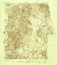
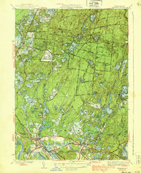
 1938 Sandwich1938 Print · USGSCape Cod's north shore and central pine barrens appear in detail during the late 1930s. Genealogists can locate family names at Tobey Cem and Percival Cem, or trace the rail corridor of the New York New Haven and Hartford.
 - 1939 Map of Sandwich
 1939 Sandwich1939 Print · USGSCape Cod's northern shore and the interior of Barnstable County appear here in the late 1930s, featuring a landscape of expansive salt marshes and numerous kettle ponds. Genealogists can locate family landmarks like Freeman Cem and the Old Quaker Meetinghouse or trace the early Cape Cod Airport.
 - 1939 Map of Wareham
 1939 Wareham1939 Print · USGSPlymouth County cranberry country and coastal industry are well-established in this late 1930s survey. Researchers can trace the New Haven RR through South Wareham or locate family plots near Parker Mills and the Cemetery.5 unique versions available
End of results
Showing maps 1-9 of 9
Top cities of Barnstable County
- Falmouth historical maps
- Yarmouth historical maps
- Sandwich historical maps
- Bourne historical maps
- Dennis historical maps
- Mashpee historical maps
See more
Frequently asked questions
- What are the different types of historical maps available for Barnstable County?
- What is the oldest map of Barnstable County?
- Where can I purchase historical maps of Barnstable County for my home or office?
- Where can I download high-res historical maps of Barnstable County?
- Are there historical topographic maps available for Barnstable County?
- Is there historical aerial imagery available for Barnstable County?
- Where are historical maps of Barnstable County sourced from?