1990s Maps of Barnstable County, Massachusetts
Explore 4 historic maps of Barnstable County from the 1990s. These maps offer a rare glimpse into what life looked like during the 1990s — showing old roads, neighborhoods, homes, and landmarks that have changed or disappeared over time.
Whether you're researching your family's past, planning a metal detecting trip, or studying how Barnstable County's landscape evolved across the 1990s, these high-resolution maps are a powerful tool for exploring the history of this region.
- Focus on a specific era: All maps on this page are from the 1990s, giving you a focused view of this time period.
- See what’s changed: Compare century-old streets, trails, and buildings to today's modern landscape using overlays and satellite layers.
- Research with precision: Use these maps for genealogy, historical research, land use analysis, or educational projects.
- View, download, or print: Maps are fully viewable online in high resolution, and can be downloaded or printed for your own records.
Start exploring Barnstable County's history through authentic maps from the 1990s. This is your window into the past.
Barnstable County, MA maps
(4)- 1993 Map of Chatham, 1994 Print
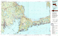
 1993 Chatham1994 Print · USGSBarnstable County's outer coast appears here in the early nineties, showcasing the protected lands of the Cape Cod National Seashore. Researchers can trace the shoreline from Nauset Beach Lighthouse down to the Monomoy National Wildlife Refuge.
 - 1994 Map of New Bedford
 1994 New Bedford1994 Print · USGSSoutheastern Massachusetts and the Cape are shown in high detail during the mid-nineties, capturing the region's unique maritime geography and coastal infrastructure. Trace the transition from the industrial New Bedford Harbor to protected lands like Cape Cod National Seashore and Otis Air Force Base.
 - 1994 Map of Martha's Vineyard
 1994 Martha's Vineyard1994 Print · USGSThe islands of Martha's Vineyard and Nantucket are captured here in the mid-nineties, showing the established coastal villages and extensive conservation lands. Researchers can trace the boundaries of Manuel F Correllus State Forest or locate landmarks like the Lighthouse at Gay Head and Chappaquiddick Island.
 - 1994 Map of Siasconset
 1994 Siasconset1994 Print · USGSThe eastern edge of Nantucket at the close of the twentieth century shows a landscape of coastal bluffs and seaside villages. Trace family roots and local history near Siasconset or study landmarks like Sankaty Head Light and Sesachacha Pond.
End of results
Showing maps 1-4 of 4
Top cities of Barnstable County
- Falmouth historical maps
- Yarmouth historical maps
- Sandwich historical maps
- Bourne historical maps
- Dennis historical maps
- Mashpee historical maps
See more
Frequently asked questions
- What are the different types of historical maps available for Barnstable County?
- What is the oldest map of Barnstable County?
- Where can I purchase historical maps of Barnstable County for my home or office?
- Where can I download high-res historical maps of Barnstable County?
- Are there historical topographic maps available for Barnstable County?
- Is there historical aerial imagery available for Barnstable County?
- Where are historical maps of Barnstable County sourced from?