1940s Maps of Barnstable County, Massachusetts
Explore 43 historic maps of Barnstable County from the 1940s. These maps offer a rare glimpse into what life looked like during the 1940s — showing old roads, neighborhoods, homes, and landmarks that have changed or disappeared over time.
Whether you're researching your family's past, planning a metal detecting trip, or studying how Barnstable County's landscape evolved across the 1940s, these high-resolution maps are a powerful tool for exploring the history of this region.
- Focus on a specific era: All maps on this page are from the 1940s, giving you a focused view of this time period.
- See what’s changed: Compare century-old streets, trails, and buildings to today's modern landscape using overlays and satellite layers.
- Research with precision: Use these maps for genealogy, historical research, land use analysis, or educational projects.
- View, download, or print: Maps are fully viewable online in high resolution, and can be downloaded or printed for your own records.
Start exploring Barnstable County's history through authentic maps from the 1940s. This is your window into the past.
Barnstable County, MA maps
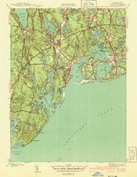
(43)- 1940 Map of Sagamore
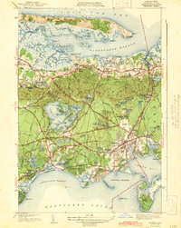
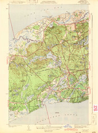
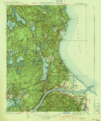 1940 Sagamore1940 Print · USGSThe Cape Cod Canal area in the 1940s reveals a maritime landscape transitioning toward modern infrastructure. Trace family roots and local history through Sagamore village, the Indian Cem, and the rail lines of the New York New Haven and Hartford.4 unique versions available
 - 1940 Map of Sandwich
 1940 Sandwich1940 Print · USGSCape Cod’s oldest town and the surrounding marshes are captured just before the war as a landscape of rural villages and glacial ponds. Genealogy researchers can trace family landmarks like the Tobey Cem, the Old Quaker Meetinghouse, and the Cape Cod Airport.
 - 1940 Map of Sconticut Neck
 1940 Sconticut Neck1940 Print · USGSCoastal Fairhaven and its surrounding islands appear here in the mid-1930s, showing the early layout of the peninsula and its maritime borders. Trace the path of Sconticut Neck Road to the tip at Sconticut Point or explore the shores of West Island.3 unique versions available
 - 1941 Map of Woods Hole
 1941 Woods Hole1941 Print · USGSThe Buzzards Bay shoreline and the Elizabeth Islands appear here just before the mid-century, featuring a landscape of maritime industry and coastal estates. Researchers can trace the New York New Haven and Hartford rail line, locate family plots at Crowell Cem, or explore the marshes of Great Sippowisset Swamp.3 unique versions available
 - 1941 Map of Onset
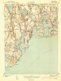
 1941 Onset1941 Print · USGSCoastal Massachusetts at the start of the 1940s reveals a landscape of maritime recreation and local industry. Genealogists and historians can trace the development of Onset and East Marion, or locate landmarks like the Wings Neck Lighthouse and Agawam Cem.4 unique versions available
 - 1941 Map of Cotuit
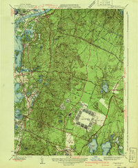
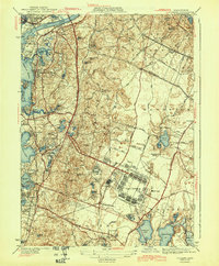
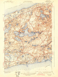
 1941 Cotuit1941 Print · USGSCape Cod's south shore and the villages of Barnstable appear here in the late thirties, before modern coastal development reshaped the peninsula. Researchers can trace ancestral sites like the Old Indian School, St Marys church, and family plots in Hillside Cem.2 unique versions available
 - 1941 Map of Falmouth
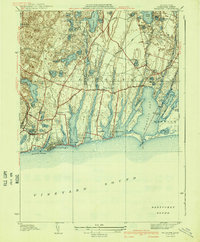 1941 Falmouth1941 Print · USGSCape Cod's south shore appears just before the mid-century boom, showing the maritime and residential character of the 1930s. Genealogists and historians can trace family-named areas like Smarttown, old congregations at East End Ch, and the development of Waquoit Village.3 unique versions available
 - 1941 Map of Pocasset
 1941 Pocasset1941 Print · USGSCape Cod was undergoing significant military expansion in the early 1940s while maintaining its seaside character. Researchers can trace the layout of Camp Edwards and Otis Field alongside coastal villages like Cataumet and Monument Beach.2 unique versions available
 - 1942 Map of Cape Cod Bay
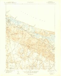
 1942 Cape Cod Bay1942 Print · USGSThe mid-Cape and Outer Cape regions are shown here during the early war years, documenting a landscape of coastal villages and maritime trade. Researchers can trace family roots through old settlements like South Truro, find the grounds of Camp Edwards, or locate historic aids like Sandy Neck Light.
 - 1942 Map of Monomoy Point
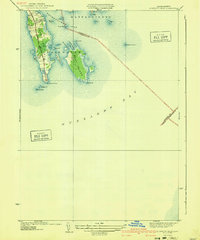
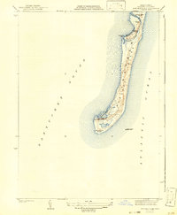 1942 Monomoy Point1942 Print · USGSMonomoy Island and the surrounding Cape Cod waters are captured here just before the mid-century, showing a landscape of shifting sands and maritime outposts. Researchers can locate the Coast Guard Sta, the Stone Horse Light Ship, and private sporting sites like the Monomoy Brant Club.2 unique versions available
 - 1942 Map of Marthas Vineyard
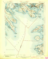
 1942 Marthas Vineyard1942 Print · USGSMartha's Vineyard and the Elizabeth Islands appear here during the early years of the second World War. Researchers can trace historical lighthouse locations like Gay Head LH and Tarpaulin Cove LH, and explore the 1940s boundaries of Edgartown and Vineyard Haven.
 - 1942 Map of Chatham
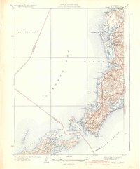
 1942 Chatham1942 Print · USGSCoastal life on Cape Cod at the start of the 1940s centered on maritime safety and family-named waters. Researchers can trace the locations of the Chatham Lighthouse, Peoples Cem, and the long-lost Old Harbor C G Sta on the outer beach.
 - 1942 Map of Hyannis
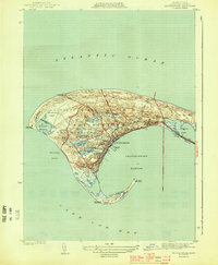
 1942 Hyannis1942 Print · USGSBarnstable and Hyannis are shown here just before the mid-century boom, featuring the early footprint of maritime and rail infrastructure. Researchers can trace family sites at Lothrop Hill Cem, the Hyannis State Teachers College, and the old Yarmouth Sta.4 unique versions available
 - 1942 Map of New Bedford
 1942 New Bedford1942 Print · USGSSoutheastern Massachusetts at the start of the 1940s shows a region defined by maritime defense and industrial rail corridors. Genealogists and historians can trace the massive Camp Edwards boundary, old rail stops like Rock Station, and vanished local industry at Paper Mill Village.2 unique versions available
 - 1942 Map of Nauset, 1943 Print
 1942 Nauset1943 Print · USGSLower Cape Cod and its maritime frontier are captured here during the early Forties, showing the vital coastal infrastructure of the era. Genealogists and historians can trace family locations and landmarks from South Wellfleet to Chatham, including Nauset Beach Light and several Life Saving Stations.
 - 1942 Map of Nantucket, 1943 Print
 1942 Nantucket1943 Print · USGSNantucket and Chappaquiddick Islands are captured here during the early years of the Second World War. Genealogists and historians can trace the early roads to Siasconset, the Steamship Ferry route, and the locations of Madd Aket LSS and Coskata LSS.
 - 1943 Map of Cotuit
 1943 Cotuit1943 Print · USGSCape Cod's south shore appears in the early forties as a landscape of interconnected bays and quiet villages before the post-war building boom. Genealogists and local historians can trace family plots in the Old Barnstable Cem or locate the historic school and church sites in Marstons Mills and Santuit.3 unique versions available
 - 1943 Map of Pocasset
 1943 Pocasset1943 Print · USGSCape Cod was undergoing a massive military transformation during the early forties, even as its traditional coastal villages remained intact. Researchers can trace the sprawling layout of Camp Edwards and Otis Field alongside local landmarks like Pocasset Sta and the Beaton Bog.2 unique versions available
 - 1943 Map of Sandwich
 1943 Sandwich1943 Print · USGSCape Cod's northern shore and interior kettle ponds are documented in the early 1940s, just as modern infrastructure began to shape the region. Genealogists can trace family roots at the Old Quaker Meetinghouse, Freeman Cem, and the historic village of Sandwich.5 unique versions available
 - 1943 Map of Dennis
 1943 Dennis1943 Print · USGSMid-Cape Cod during the early war years remains a landscape of quiet coastal villages and sprawling kettle ponds. Researchers can trace the old New York New Haven and Hartford rail line to Bass River Sta or locate family plots in Howes Cem and Swan Pond Cem.3 unique versions available
 - 1943 Map of Harwich
 1943 Harwich1943 Print · USGSMid-Cape Cod in the early 1940s shows a landscape of glacial kettle ponds and coastal villages connected by the New York New Haven and Hartford RR. Genealogists can trace family names through the Dillingham Cem and Evergreen Cem or locate old school sites like Sea Pine Sch.3 unique versions available
 - 1943 Map of Chatham
 1943 Chatham1943 Print · USGSCape Cod’s southeastern elbow is captured here during the early years of the war, showing a world of maritime navigation and coastal hamlets. You can trace family history at Peoples Cem or locate historic beacons like Chatham Lighthouse and Stage Harbor Lighthouse.3 unique versions available
 - 1943 Map of Plymouth
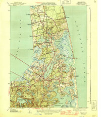
 1943 Plymouth1943 Print · USGSThe coastal stretch from Plymouth to the Cape Cod Canal shows its wartime character here, when rail travel still connected these maritime towns. Genealogists can trace early homesteads and landmarks near Billington Sea, Manomet, and the Old Colony Railroad corridor.
 - 1944 Map of Orleans
 1944 Orleans1944 Print · USGSCoastal life on the Outer Cape is captured here during the early forties, showing the transition from traditional maritime work to early recreation. Trace the old rail line of the New York New Haven and Hartford or locate historical landmarks like the Nauset Beach Lighthouse and Evergreen Cem.3 unique versions available
 - 1944 Map of Provincetown
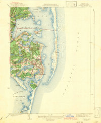
 1944 Provincetown1944 Print · USGSCape Cod's outer tip shows its mid-century maritime character and infrastructure just before post-war tourism transformed the landscape. Researchers can trace the original rail lines of the New Haven and Hartford and locate historic markers like the Pilgrim Monument and Race Point Lighthouse.3 unique versions available
Showing maps 1-25 of 43
Top cities of Barnstable County
- Falmouth historical maps
- Yarmouth historical maps
- Sandwich historical maps
- Bourne historical maps
- Dennis historical maps
- Mashpee historical maps
See more
Frequently asked questions
- What are the different types of historical maps available for Barnstable County?
- What is the oldest map of Barnstable County?
- Where can I purchase historical maps of Barnstable County for my home or office?
- Where can I download high-res historical maps of Barnstable County?
- Are there historical topographic maps available for Barnstable County?
- Is there historical aerial imagery available for Barnstable County?
- Where are historical maps of Barnstable County sourced from?