1910s Maps of Plymouth County, Massachusetts
Explore 7 historic maps of Plymouth County from the 1910s. These maps offer a rare glimpse into what life looked like during the 1910s — showing old roads, neighborhoods, homes, and landmarks that have changed or disappeared over time.
Whether you're researching your family's past, planning a metal detecting trip, or studying how Plymouth County's landscape evolved across the 1910s, these high-resolution maps are a powerful tool for exploring the history of this region.
- Focus on a specific era: All maps on this page are from the 1910s, giving you a focused view of this time period.
- See what’s changed: Compare century-old streets, trails, and buildings to today's modern landscape using overlays and satellite layers.
- Research with precision: Use these maps for genealogy, historical research, land use analysis, or educational projects.
- View, download, or print: Maps are fully viewable online in high resolution, and can be downloaded or printed for your own records.
Start exploring Plymouth County's history through authentic maps from the 1910s. This is your window into the past.
Plymouth County, MA maps
(7)- 1915 Map of Falmouth, 1943 Print
 1915 Falmouth1943 Print · USGSUpper Cape Cod during the mid-forties reveals a landscape of growing military activity alongside traditional coastal villages. Genealogists and historians can trace the foundations of Camp Edwards and find historic post offices at Waquoit Village or Monument Beach.
 - 1916 Map of Middleboro
 1916 Middleboro1916 Print · USGSSoutheastern Massachusetts at the height of its rail-and-mill era shows a dense network of stations and wetlands. Trace the Old Colony Railroad lines to sites like Haskins Station, Paper Mill Village, and the Lakeville State Sanatarium.
 - 1918 Map of Duxbury
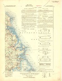 1918 Duxbury1918 Print · USGSThe Plymouth County coast is captured during the Great War era in this detailed military study of its shorelines and rail hubs. Trace maritime landmarks like Gurnet Lights and the Old Tower, or find local industrial history at the Saw Mill and Furnace.2 unique versions available
 - 1918 Map of Middleboro, 1921 Print
 1918 Middleboro1921 Print · USGSSoutheastern Massachusetts at the end of the Great War reveals a landscape defined by cranberry bogs, cedar swamps, and a dense network of Old Colony Railroad lines. Genealogists and historians can trace rail stops like Haskins Station, the grounds of the Lakeville State Sanatarium, and old villages like The Green.
 - 1918 Map of New Bedford, 1921 Print
 1918 New Bedford1921 Print · USGSThe Buzzards Bay coastline thrived with rail and maritime commerce during the early twentieth century. Researchers can trace historic shorelines and infrastructure at New Bedford, Fairhaven, and Clark Point Light.
 - 1918 Map of Taunton, 1921 Print
 1918 Taunton1921 Print · USGSSoutheastern Massachusetts at the close of the Great War is a dense network of industrial rail lines and riverside villages. You can trace the path of the Old Colony Railroad Main Line or locate local landmarks like the Copper Works and Annawon Rock.
 - 1919 Map of Dedham
 1919 Dedham1919 Print · USGSNorfolk County at the close of the Great War reveals a landscape defined by the Blue Hills Reservation and a dense network of industrial rail lines. Genealogists and historians can trace old neighborhood boundaries in Readville and Islington or locate lost trackside stops along the Old Colony RR.
End of results
Showing maps 1-7 of 7
Top cities of Plymouth County
- Brockton historical maps
- Plymouth historical maps
- Bridgewater historical maps
- Marshfield historical maps
- Hingham historical maps
- Wareham historical maps
See more
Frequently asked questions
- What are the different types of historical maps available for Plymouth County?
- What is the oldest map of Plymouth County?
- Where can I purchase historical maps of Plymouth County for my home or office?
- Where can I download high-res historical maps of Plymouth County?
- Are there historical topographic maps available for Plymouth County?
- Is there historical aerial imagery available for Plymouth County?
- Where are historical maps of Plymouth County sourced from?