1960s Maps of Plymouth County, Massachusetts
Explore 24 historic maps of Plymouth County from the 1960s. These maps offer a rare glimpse into what life looked like during the 1960s — showing old roads, neighborhoods, homes, and landmarks that have changed or disappeared over time.
Whether you're researching your family's past, planning a metal detecting trip, or studying how Plymouth County's landscape evolved across the 1960s, these high-resolution maps are a powerful tool for exploring the history of this region.
- Focus on a specific era: All maps on this page are from the 1960s, giving you a focused view of this time period.
- See what’s changed: Compare century-old streets, trails, and buildings to today's modern landscape using overlays and satellite layers.
- Research with precision: Use these maps for genealogy, historical research, land use analysis, or educational projects.
- View, download, or print: Maps are fully viewable online in high resolution, and can be downloaded or printed for your own records.
Start exploring Plymouth County's history through authentic maps from the 1960s. This is your window into the past.
Plymouth County, MA maps
(24)- 1961 Map of Boston
 1961 Boston1961 Print · USGSThe Massachusetts coastline and its industrial interior are detailed here in the mid-twentieth century, from the Monadnock highlands to Cape Cod. Researchers can trace the rail routes of the Boston and Maine or locate landmarks like Fort Devens and the Wachusett Reservoir.2 unique versions available
 - 1961 Map of Duxbury, 1963 Print
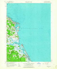
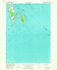
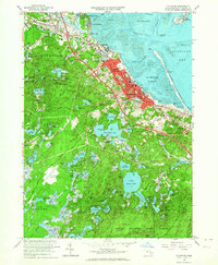
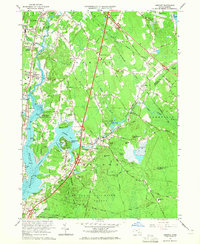
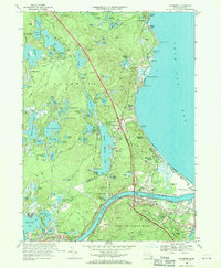
 1961 Duxbury1963 Print · USGSThe Plymouth County coast in the early sixties reveals a landscape rich in Pilgrim history and maritime tradition. Trace early colonial roots at the John Alden House, the Standish Monument, and the iconic Plymouth Lighthouse on Gurnet Point.
 - 1961 Map of Scituate, 1963 Print
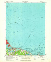
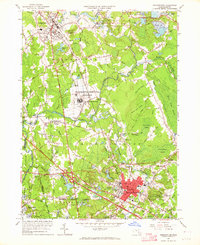
 1961 Scituate1963 Print · USGSThe Plymouth County coast in the early sixties reveals a transition from traditional maritime villages to expanding shoreline communities. Trace local history through the Coast Guard Station, the Meeting House Lane Cemetery and Church, and the Scituate Station rail stop.2 unique versions available
 - 1961 Map of Cohasset, 1963 Print
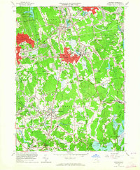
 1961 Cohasset1963 Print · USGSThe South Shore at the start of the sixties reveals a blend of coastal heritage and postwar growth. Local historians can trace family roots through the Old First Parish Cem or locate historic sites like Kings Landing and the Old Oaken Bucket Homestead.2 unique versions available
 - 1961 Map of Nantasket, 1963 Print
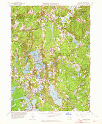
 1961 Nantasket1963 Print · USGSThe Massachusetts coastline in the early sixties shows the vibrant seaside life and maritime hazards of the South Shore. Genealogists and local historians can trace family properties near Paragon Park, North Cohasset, and the historic Boston Light.2 unique versions available
 - 1962 Map of Snipatuit Pond, 1963 Print
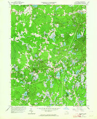
 1962 Snipatuit Pond1963 Print · USGSSoutheastern Massachusetts in the early sixties was a landscape of cranberry bogs and glacial ponds. Genealogists and local historians can trace family-named crossroads like Bisbee Corner and Vaughn Hill or locate rural landmarks such as Union Ch.2 unique versions available
 - 1962 Map of Sconticut Neck, 1963 Print
 1962 Sconticut Neck1963 Print · USGSThe Buzzards Bay shoreline comes alive in the early sixties, showing the growing residential grid of West Island and the coastal reach of Sconticut Neck. Researchers can trace old property boundaries near Silver Shell Beach and locate offshore markers like Angelica Rock and Brant Island.2 unique versions available
 - 1962 Map of Plympton, 1964 Print
 1962 Plympton1964 Print · USGSPlymouth County cranberry country is preserved here in the early sixties, showing the intricate network of bogs and brooks that defined local industry. Trace family roots and old property lines near Plympton, Lakenham Cem, or the rural crossroads of Shurtleff Corner.2 unique versions available
 - 1962 Map of Taunton, 1964 Print
 1962 Taunton1964 Print · USGSThe industrial and riverfront character of Taunton and Raynham is caught here in the early sixties, showing the city's growth alongside vast wetlands and bogs. Trace family roots and local history at institutional landmarks like the Taunton State Hospital and Mayflower Hill Cemetery.
 - 1962 Map of Manomet, 1964 Print
 1962 Manomet1964 Print · USGSCoastal Plymouth in the early sixties reveals a landscape of expanding beach communities and traditional cranberry cultivation. Researchers can trace family-named sites and local landmarks like Manomet Heights, the White Horse Cem, and Churchill Landing.2 unique versions available
 - 1962 Map of Marion, 1964 Print
 1962 Marion1964 Print · USGSCoastal Plymouth County villages thrived in the early sixties, balancing a traditional cranberry economy with a growing maritime identity. Genealogists and local historians can trace family roots through Tinkhamtown, Sturtevant Mill, and the Old Landing Cem.
 - 1962 Map of Plymouth, 1964 Print
 1962 Plymouth1964 Print · USGSCoastal Massachusetts at the start of the sixties reveals a landscape where colonial heritage meets modern growth. Genealogists and historians can trace family roots through Evergreen Cemetery or locate old neighborhood landmarks like Hedges Sch, St Josephs Ch, and the coastal battery at Fort Standish.2 unique versions available
 - 1962 Map of Bridgewater, 1964 Print
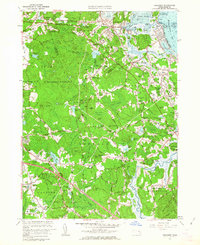
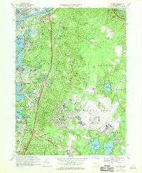
 1962 Bridgewater1964 Print · USGSPlymouth County enters a period of post-war suburban and industrial growth as the rail lines of the New York New Haven and Hartford still anchor the local economy. Trace the footprints of Paper Mill Village, the Lakeville State Sanatorium, and old local landmarks like the Pratt Free Sch.3 unique versions available
 - 1962 Map of Whitman, 1964 Print
 1962 Whitman1964 Print · USGSSoutheastern Massachusetts' shoe-making and cranberry-growing centers are caught in a period of steady suburban growth. Genealogists can trace family plots at St Patricks Cemetery and Colebrook Cemetery or locate early civic landmarks like the Dyer Sch.2 unique versions available
 - 1962 Map of Hanover, 1964 Print
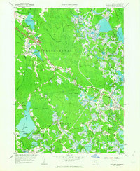
 1962 Hanover1964 Print · USGSPlymouth County in the early sixties reveals a landscape of sprawling cranberry bogs and growing residential villages nestled between major glacial ponds. Genealogists and historians can locate family landmarks like Briggs Cem, the First Baptist Ch, and old rail points at Winslows Crossing and Curtis Crossing.2 unique versions available
 - 1963 Map of Providence
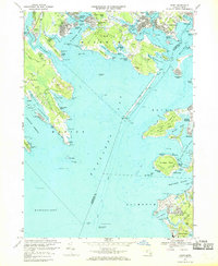
 1963 Providence1963 Print · USGSSouthern New England's coastal and industrial heartland is captured here in the early sixties, from the Rhode Island mainland to the far reaches of the Cape. Researchers can trace mid-century growth in Providence or locate landmarks on Marthas Vineyard and Nantucket Island.
 - 1963 Map of Assawompset Pond, 1965 Print
 1963 Assawompset Pond1965 Print · USGSSoutheastern Massachusetts’ massive lake system is shown here in the early sixties, capturing the growth of new shoreline communities. Researchers can trace family ties at Morton Cem, locate the Apponequet Regional High Sch, or explore the storied grounds of Bettys Neck.
 - 1963 Map of Assonet, 1965 Print
 1963 Assonet1965 Print · USGSSoutheastern Massachusetts in the early sixties showcases a transition from historic riverfront settlements to a modernizing transportation hub. Trace the heritage of Assonet and Dighton through landmarks like the Assonet Burying Ground and Old Quaker Cem.2 unique versions available
 - 1963 Map of Brockton, 1965 Print
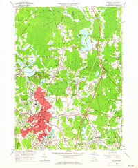
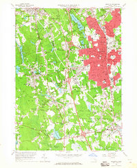 1963 Brockton1965 Print · USGSBrockton and the surrounding Plymouth County townships are shown here during a mid-century period of growth and expansion. Genealogists and local historians can trace family roots through numerous named junctions and sites like Pratts Corner, Easton Sta, and Melrose Cemetery.
 - 1964 Map of New Bedford North, 1966 Print
 1964 New Bedford North1966 Print · USGSCoastal Massachusetts at the height of the mid-century shows the industrial heart of New Bedford and the developing residential reaches of Acushnet. Genealogists and historians can trace numerous schools and cemeteries, from Long Plain Cem to the Sacred Heart Academy.
 - 1967 Map of Onset, 1969 Print
 1967 Onset1969 Print · USGSThe northern shore of Buzzards Bay is captured here in the late sixties, showing a landscape defined by tidal rivers and growing coastal colonies. Researchers can trace the layout of Parkwood Beach, the grounds of the Maritime Academy, and early Cranberry Bogs.3 unique versions available
 - 1967 Map of Pocasset, 1970 Print
 1967 Pocasset1970 Print · USGSThe Upper Cape coast and its military interior are shown here in the late sixties as the region's modern infrastructure took shape. Genealogists and historians can trace coastal neighborhoods from Gray Gables to Cataumet or locate the sprawling runways of Otis Air Force Base.3 unique versions available
 - 1967 Map of Sagamore, 1970 Print
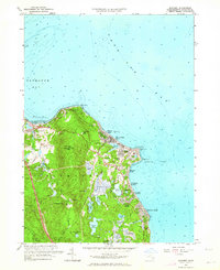
 1967 Sagamore1970 Print · USGSCape Cod in the late sixties shows a landscape of growing seaside villages and expanding transit corridors centered around the Cape Cod Canal. Local historians can trace family sites at the Sandwich Cemetery and Savery Cem, or explore the mid-century footprint of Otis Air Force Base.3 unique versions available
 - 1967 Map of Woods Hole, 1970 Print
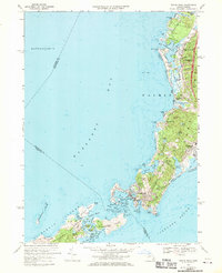 1967 Woods Hole1970 Print · USGSWoods Hole and the Falmouth coastline are captured in the late sixties, a period when maritime research and tourism shaped the local economy. Genealogists and historians can trace rail lines like the Penn Central, find the Crowell Cem, or explore the Elizabeth Islands.3 unique versions available
End of results
Showing maps 1-24 of 24
Top cities of Plymouth County
- Brockton historical maps
- Plymouth historical maps
- Bridgewater historical maps
- Marshfield historical maps
- Hingham historical maps
- Wareham historical maps
See more
Frequently asked questions
- What are the different types of historical maps available for Plymouth County?
- What is the oldest map of Plymouth County?
- Where can I purchase historical maps of Plymouth County for my home or office?
- Where can I download high-res historical maps of Plymouth County?
- Are there historical topographic maps available for Plymouth County?
- Is there historical aerial imagery available for Plymouth County?
- Where are historical maps of Plymouth County sourced from?