1950s Maps of Plymouth County, Massachusetts
Explore 16 historic maps of Plymouth County from the 1950s. These maps offer a rare glimpse into what life looked like during the 1950s — showing old roads, neighborhoods, homes, and landmarks that have changed or disappeared over time.
Whether you're researching your family's past, planning a metal detecting trip, or studying how Plymouth County's landscape evolved across the 1950s, these high-resolution maps are a powerful tool for exploring the history of this region.
- Focus on a specific era: All maps on this page are from the 1950s, giving you a focused view of this time period.
- See what’s changed: Compare century-old streets, trails, and buildings to today's modern landscape using overlays and satellite layers.
- Research with precision: Use these maps for genealogy, historical research, land use analysis, or educational projects.
- View, download, or print: Maps are fully viewable online in high resolution, and can be downloaded or printed for your own records.
Start exploring Plymouth County's history through authentic maps from the 1950s. This is your window into the past.
Plymouth County, MA maps
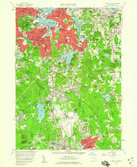
(16)- 1950 Map of Plymouth, 1956 Print
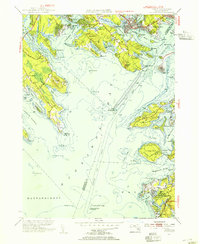
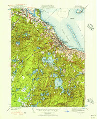 1950 Plymouth1956 Print · USGSCoastal Massachusetts at mid-century reveals a landscape of maritime tradition and growing rail-side industry. Genealogists and historians can trace the neighborhoods of Rocky Nook and Chiltonville or locate landmarks like Russell Mill and Fort Standish.2 unique versions available
 - 1951 Map of Assonet
 1951 Assonet1951 Print · USGSSoutheastern Massachusetts in the early fifties reveals a landscape defined by the winding Taunton River and its industrial and agricultural shoreline. Researchers can trace family history through dozens of landmarks like the Assonet Burial Ground, Dighton Cem, and the County Agricultural School.3 unique versions available
 - 1951 Map of Sagamore, 1952 Print
 1951 Sagamore1952 Print · USGSCoastal Massachusetts at the start of the 1950s reveals a transition from agricultural cranberry bogs to a strategic military and transit hub. Genealogists and historians can trace the Indian Cem, the historic Old Sandwich Road, and local landmarks like the Coast Guard Sta.4 unique versions available
 - 1953 Map of Pocasset, 1954 Print
 1953 Pocasset1954 Print · USGSUpper Cape Cod in the early fifties shows a region balanced between its maritime heritage and a massive mid-century military expansion. You can trace the rail lines of the Pocasset Sta and locate local landmarks like the Pocasset Golf Club and the Bourne Bridge.4 unique versions available
 - 1953 Map of Woods Hole, 1954 Print
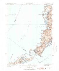 1953 Woods Hole1954 Print · USGSThe Cape Cod coastline near Falmouth in the 1950s shows a maritime landscape of harbors and early vacation development. Genealogists and historians can trace the New Haven and Hartford RR line through Sippowisset or locate family plots at Crowell Cem.4 unique versions available
 - 1953 Map of Duxbury, 1954 Print
 1953 Duxbury1954 Print · USGSThe South Shore of Massachusetts appears here in the early fifties, caught between its deep colonial roots and its growth as a coastal destination. Genealogists and historians can trace family sites like the John Alden House and the Burying Ground.
 - 1953 Map of Onset, 1954 Print
 1953 Onset1954 Print · USGSBuzzards Bay shorelines in the early fifties reveal a landscape of summer colonies and maritime traditions during a period of coastal growth. Researchers can trace family estates and local landmarks from the Beverly Yacht Club to the Cleveland Ledge Lighthouse and Sacred Heart Seminary.4 unique versions available
 - 1954 Map of Blue Hills
 1954 Blue Hills1954 Print · USGSNorfolk County in the mid-1950s reveals a landscape of growing towns and preserved highlands at the edge of the Boston metropolitan area. Genealogists and local historians can trace family plots in Blue Hills Cem or locate historic institutions like Thayer Academy and the Blue Hill Observatory.
 - 1956 Map of Boston, 1967 Print
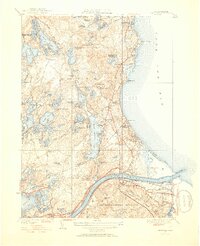
 1956 Boston1967 Print · USGSThe Massachusetts coastline and industrial interior are seen here during the mid-century peak of suburban and highway expansion. Researchers can trace historic harbor defenses like Fort Revere, local landmarks such as Faneuil Hall, and the vast Parker River National Wildlife Refuge.6 unique versions available
 - 1957 Map of Providence
 1957 Providence1957 Print · USGSCoastal New England at the height of the mid-century era shows a landscape shaped by maritime industry and Cold War defense. Genealogists and historians can trace the reach of the New York, New Haven & Hartford RR and locate legacy sites like Fort Adams and Quonset Point Naval Air Station.
 - 1957 Map of Wareham, 1959 Print
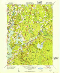
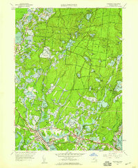 1957 Wareham1959 Print · USGSCoastal and interior Plymouth County come into focus during the late fifties, showing the interplay between traditional cranberry bogs and growing summer colonies. Researchers can trace family roots in South Carver or locate mid-century sites like the Drive-in Theater and Camp Squanto.2 unique versions available
 - 1958 Map of Boston
 1958 Boston1958 Print · USGSEastern Massachusetts and southern New Hampshire are shown at the height of the industrial era, before the full expansion of the interstate system. Trace coastal defenses at Fort Warren, historic rail lines like the Boston and Maine, and the development of the Mass. 128 corridor.2 unique versions available
 - 1958 Map of Providence
 1958 Providence1958 Print · USGSThe Rhode Island and Massachusetts coastlines are shown in detail during the late 1950s, from the urban cores to the tips of the islands. Researchers can trace the mid-century footprint of Quonset Point Naval Air Station, the defense works at Fort Adams, and the rail network of the New York, New Haven and Hartford RR.
 - 1958 Map of Hull, 1959 Print
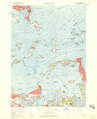 1958 Hull1959 Print · USGSBoston Harbor's outer islands and the narrow Hull peninsula are captured here in the late fifties during a period of active military and institutional use. Researchers can locate coastal batteries at Fort Andrews, trace the neighborhood streets of Adams Shore, or find the Stony Beach Coast Guard Sta.2 unique versions available
 - 1958 Map of Blue Hills, 1960 Print
 1958 Blue Hills1960 Print · USGSThe Blue Hills area south of Boston was evolving rapidly in the late fifties as new expressways cut through the ancient granite hills. Genealogists and local historians can locate long-standing institutions like Thayer Academy, family plots in Central Cemetery, and industrial landmarks including the Quarries of West Quincy.2 unique versions available
 - 1958 Map of Weymouth, 1960 Print
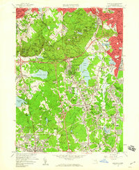
 1958 Weymouth1960 Print · USGSCoastal Massachusetts at the end of the fifties shows a landscape of growing suburban centers and significant military installations. Genealogists can trace family locations near Old North Cem, Holy Family Sch, and the South Weymouth Air Station.2 unique versions available
End of results
Showing maps 1-16 of 16
Top cities of Plymouth County
- Brockton historical maps
- Plymouth historical maps
- Bridgewater historical maps
- Marshfield historical maps
- Hingham historical maps
- Wareham historical maps
See more
Frequently asked questions
- What are the different types of historical maps available for Plymouth County?
- What is the oldest map of Plymouth County?
- Where can I purchase historical maps of Plymouth County for my home or office?
- Where can I download high-res historical maps of Plymouth County?
- Are there historical topographic maps available for Plymouth County?
- Is there historical aerial imagery available for Plymouth County?
- Where are historical maps of Plymouth County sourced from?