2020s Maps of Plymouth, Massachusetts
Explore 16 historic maps of Plymouth from the 2020s. These maps offer a rare glimpse into what life looked like during the 2020s — showing old roads, neighborhoods, homes, and landmarks that have changed or disappeared over time.
Whether you're researching your family's past, planning a metal detecting trip, or studying how Plymouth's landscape evolved across the 2020s, these high-resolution maps are a powerful tool for exploring the history of this region.
- Focus on a specific era: All maps on this page are from the 2020s, giving you a focused view of this time period.
- See what’s changed: Compare century-old streets, trails, and buildings to today's modern landscape using overlays and satellite layers.
- Research with precision: Use these maps for genealogy, historical research, land use analysis, or educational projects.
- View, download, or print: Maps are fully viewable online in high resolution, and can be downloaded or printed for your own records.
Start exploring Plymouth's history through authentic maps from the 2020s. This is your window into the past.
Plymouth, MA maps
(16)- 2021 Map of Duxbury, 2021 Print
 2021 Duxbury2021 Print · USGSCovers Plymouth, including Marshfield, Pembroke, and other nearby areas
 - 2021 Map of Manomet, 2021 Print
 2021 Manomet2021 Print · USGSCovers Plymouth, including Churchill Landing, Beach Park, and other nearby areas
 - 2021 Map of Sandwich OE N, 2021 Print
 2021 Sandwich OE N2021 Print · USGSCovers Plymouth, including Sandwich, Bourne, and other nearby areas
 - 2021 Map of Sagamore, 2021 Print
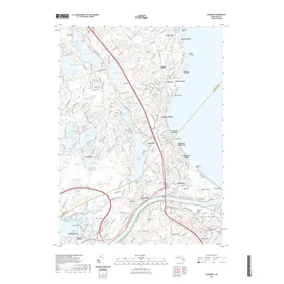 2021 Sagamore2021 Print · USGSCovers Plymouth, including Wareham, Sandwich, and other nearby areas
 - 2021 Map of Duxbury OE E, 2021 Print
 2021 Duxbury OE E2021 Print · USGSCovers Plymouth, including Marshfield, Duxbury, and other nearby areas
 - 2021 Map of Plympton, 2021 Print
 2021 Plympton2021 Print · USGSCovers Plymouth, including Kingston, Carver, and other nearby areas
 - 2021 Map of Wareham, 2021 Print
 2021 Wareham2021 Print · USGSCovers Plymouth, including Wareham, Bourne, and other nearby areas
 - 2021 Map of Plymouth, 2021 Print
 2021 Plymouth2021 Print · USGSCovers Plymouth, including Duxbury, Kingston, and other nearby areas
 - 2024 Map of Duxbury, 2024 Print
 2024 Duxbury2024 Print · USGSThe Massachusetts coast comes into focus in this contemporary survey of the settlements between Marshfield and Kingston. Researchers can trace early family sites at the Myles Standish Burying Ground and explore old neighborhoods like Tinkertown and Pudding Hill.
 - 2024 Map of Sagamore, 2024 Print
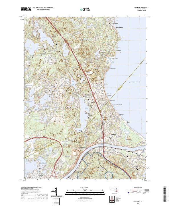 2024 Sagamore2024 Print · USGSCoastal Massachusetts at the entrance to the Cape is captured here as the maritime and military history of the region evolves. Researchers can locate numerous family burial sites like Redding Cem or the Indian Cem, and trace the path of the Cape Cod Canal past Sagamore.
 - 2024 Map of Manomet, 2024 Print
 2024 Manomet2024 Print · USGSCoastal Plymouth is seen here in recent years, showing a landscape of dense seaside villages and inland glacial ponds. Genealogists and local historians can locate Manomet Cem or the Old Indian Burying Ground Cem and trace the paths of Old Sandwich Rd.
 - 2024 Map of Sandwich OE N, 2024 Print
 2024 Sandwich OE N2024 Print · USGSCape Cod's northern shore and the historic town of Sandwich are meticulously detailed in this recent survey. Local researchers can trace coastal evolution through landmarks like Town Neck Hill, Mount Hope Cem, and the shifting Sandwich Harbor Marshes.
 - 2024 Map of Wareham, 2024 Print
 2024 Wareham2024 Print · USGSCranberry cultivation and coastal settlement meet in this contemporary look at Wareham, where industrial bogs and salt marshes shape the terrain. Researchers can trace local genealogy and land use through landmarks like Centre Cem, the Wankinco River, and White Island Shores.
 - 2024 Map of Plympton, 2024 Print
 2024 Plympton2024 Print · USGSPlymouth County at the present day retains its traditional character of cranberry cultivation and small-town hamlets. Researchers can trace historic burial sites like the Old Smallpox Cem and family plots near Plympton and Eddyville.
 - 2024 Map of Plymouth, 2024 Print
 2024 Plymouth2024 Print · USGSThe Massachusetts coast near Plymouth and Kingston is shown in the 2020s, balancing its famous colonial landmarks with extensive modern conservation lands. Genealogists and historians can locate dozens of burial sites like Old Burying Ground or the Chiltonville Cem, and trace the shore to Fort Standish.
 - 2024 Map of Duxbury OE E, 2024 Print
 2024 Duxbury OE E2024 Print · USGSThe Plymouth coastline at the dawn of the 2020s shows the delicate balance between the Atlantic and its barrier beaches. Trace the remote roads and coastal landmarks from Gurnet Point through the marshes of Saquish Neck to the sands of Duxbury Beach.
End of results
Showing maps 1-16 of 16
Top cities near Plymouth
- Marshfield historical maps
- Wareham historical maps
- Sandwich historical maps
- Bourne historical maps
- Pembroke historical maps
- Fairhaven historical maps
See more
Top neighborhoods of Plymouth
- Cedar Bushes historical maps
- Fishermans Landing historical maps
- Manomet Beach historical maps
- Manomet Bluffs historical maps
- Priscilla Beach historical maps
- White Horse Beach historical maps
See more
Frequently asked questions
- What are the different types of historical maps available for Plymouth?
- What is the oldest map of Plymouth?
- Where can I purchase historical maps of Plymouth for my home or office?
- Where can I download high-res historical maps of Plymouth?
- Are there historical topographic maps available for Plymouth?
- Is there historical aerial imagery available for Plymouth?
- Where are historical maps of Plymouth sourced from?