1970s Maps of Orange Township, Michigan
Explore 4 historic maps of Orange Township from the 1970s. These maps offer a rare glimpse into what life looked like during the 1970s — showing old roads, neighborhoods, homes, and landmarks that have changed or disappeared over time.
Whether you're researching your family's past, planning a metal detecting trip, or studying how Orange Township's landscape evolved across the 1970s, these high-resolution maps are a powerful tool for exploring the history of this region.
- Focus on a specific era: All maps on this page are from the 1970s, giving you a focused view of this time period.
- See what’s changed: Compare century-old streets, trails, and buildings to today's modern landscape using overlays and satellite layers.
- Research with precision: Use these maps for genealogy, historical research, land use analysis, or educational projects.
- View, download, or print: Maps are fully viewable online in high resolution, and can be downloaded or printed for your own records.
Start exploring Orange Township's history through authentic maps from the 1970s. This is your window into the past.
Orange Township, MI maps
(4)- 1978 Map of Ionia, 1979 Print
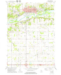 1978 Ionia1979 Print · USGSIonia and its surrounding townships are shown here in the late seventies, centered on the strategic confluence of the Grand River and Prairie Creek. Genealogists and local researchers can trace the locations of the Ionia State Reformatory, the Little White Ch, and several family cemeteries like Tuttle Cem.
 - 1978 Map of Portland North, 1979 Print
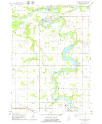 1978 Portland North1979 Print · USGSIonia County at the height of the 1970s shows a landscape defined by the convergence of the Grand River and Maple River. You can trace the industrial footprint of Muir, Lyons, and Portland through old rail grades, the Webber Dam, and the Keefer Cem.
 - 1978 Map of Portland South, 1979 Print
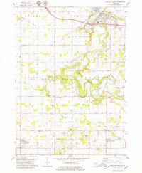 1978 Portland South1979 Print · USGSThe Grand River valley in the late seventies reveals a landscape of river-town growth and rural persistence near the Ionia and Eaton county line. Researchers can locate family landmarks like Knox Sch, East Sebewa Cem, and the old Grange Hall.
 - 1978 Map of Woodbury, 1979 Print
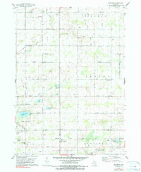 1978 Woodbury1979 Print · USGSThe rural intersection of Ionia, Barry, and Eaton counties comes into focus during the late seventies, showing a landscape of family farms and glacial lakes. Trace local roots through sites like Woodbury, Alderman Cem, and the Lakewood High Sch.2 unique versions available
End of results
Showing maps 1-4 of 4
Top cities near Orange Township
- Ionia historical maps
- Belding historical maps
- Portland historical maps
- Orleans historical maps
- Lake Odessa historical maps
- Saranac historical maps
See more
Top neighborhoods of Orange Township
Frequently asked questions
- What are the different types of historical maps available for Orange Township?
- What is the oldest map of Orange Township?
- Where can I purchase historical maps of Orange Township for my home or office?
- Where can I download high-res historical maps of Orange Township?
- Are there historical topographic maps available for Orange Township?
- Is there historical aerial imagery available for Orange Township?
- Where are historical maps of Orange Township sourced from?