1980s Maps of Iron River Township, Michigan
Explore 8 historic maps of Iron River Township from the 1980s. These maps offer a rare glimpse into what life looked like during the 1980s — showing old roads, neighborhoods, homes, and landmarks that have changed or disappeared over time.
Whether you're researching your family's past, planning a metal detecting trip, or studying how Iron River Township's landscape evolved across the 1980s, these high-resolution maps are a powerful tool for exploring the history of this region.
- Focus on a specific era: All maps on this page are from the 1980s, giving you a focused view of this time period.
- See what’s changed: Compare century-old streets, trails, and buildings to today's modern landscape using overlays and satellite layers.
- Research with precision: Use these maps for genealogy, historical research, land use analysis, or educational projects.
- View, download, or print: Maps are fully viewable online in high resolution, and can be downloaded or printed for your own records.
Start exploring Iron River Township's history through authentic maps from the 1980s. This is your window into the past.
Iron River Township, MI maps
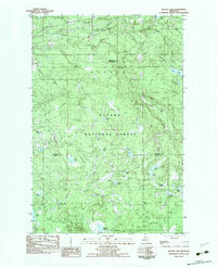
(8)- 1981 Map of Hagerman Lake
 1981 Hagerman Lake1981 Print · USGSThe Michigan-Wisconsin border comes alive in the early eighties as the Brule River winds through the twin national forests. Researchers can trace the Old Railroad Grade past Bass Lake or explore the settlement of Nelma along the riverbanks.
 - 1981 Map of Beechwood
 1981 Beechwood1981 Print · USGSIron County in the early 1980s reveals a landscape of timber and rail where small settlements like Beechwood and Basswood endure. Trace family roots at Rosehill Cem, explore the Chicago and North Western corridor, or locate the Bethany Ch.
 - 1982 Map of Lake Mitigwaki, 1983 Print
 1982 Lake Mitigwaki1983 Print · USGSUpper Peninsula wilderness in the early eighties is defined here by the dense hydrology of the Ottawa National Forest. You can trace the Chicago and North Western rail line and locate remote features like Bear Trap Dam and Lake Mitigwaki.
 - 1982 Map of Kenton, 1983 Print
 1982 Kenton1983 Print · USGSUpper Peninsula timber and river lands come into focus during the early eighties, centered on the settlement of Kenton. Researchers can trace the Old RR Grade through the Ottawa National Forest and locate family landmarks like the local Cem or the camps near Tepee Lake.
 - 1982 Map of Winslow Lake, 1983 Print
 1982 Winslow Lake1983 Print · USGSIron County's forested lake country is documented in the early 1980s, centered on the Paint River and its tributaries. Researchers can trace old logging infrastructure at Holmes Dam or locate isolated landmarks like the Big Spring Hole and Winslow Lake.
 - 1982 Map of Glitter Lake, 1983 Print
 1982 Glitter Lake1983 Print · USGSUpper Michigan's lake country is captured here in the early eighties, spanning the wooded border between Houghton and Iron counties. Researchers can trace the water systems of the Ottawa National Forest, from Passmore Springs to remote shores like Glitter Lake and Lake Thirteen.
 - 1985 Map of Perch Lake, 1986 Print
 1985 Perch Lake1986 Print · USGSIron County’s wooded lake country is captured here in the mid-1980s, centered on the Perch Lake watershed and the Ottawa National Forest. Researchers can trace old family names and small-scale industry across sites like Hannah Webb Lake and a local Gravel Pit.
 - 1989 Map of Iron River, 1990 Print
 1989 Iron River1990 Print · USGSUpper Peninsula mining and timber lands are documented here in the late 1980s, showcasing the region's industrial and natural interface. Researchers can trace the iron heritage through the Monongahela Mine and local junctions like Kelso Junction and Amasa.
End of results
Showing maps 1-8 of 8
Top cities near Iron River Township
- Iron River historical maps
- Phelps historical maps
- Stambaugh historical maps
- Caspian historical maps
- Gaastra historical maps
- Alvin historical maps
Top neighborhoods of Iron River Township
Frequently asked questions
- What are the different types of historical maps available for Iron River Township?
- What is the oldest map of Iron River Township?
- Where can I purchase historical maps of Iron River Township for my home or office?
- Where can I download high-res historical maps of Iron River Township?
- Are there historical topographic maps available for Iron River Township?
- Is there historical aerial imagery available for Iron River Township?
- Where are historical maps of Iron River Township sourced from?