1960s Maps of Ingallston Township, Michigan
Explore 5 historic maps of Ingallston Township from the 1960s. These maps offer a rare glimpse into what life looked like during the 1960s — showing old roads, neighborhoods, homes, and landmarks that have changed or disappeared over time.
Whether you're researching your family's past, planning a metal detecting trip, or studying how Ingallston Township's landscape evolved across the 1960s, these high-resolution maps are a powerful tool for exploring the history of this region.
- Focus on a specific era: All maps on this page are from the 1960s, giving you a focused view of this time period.
- See what’s changed: Compare century-old streets, trails, and buildings to today's modern landscape using overlays and satellite layers.
- Research with precision: Use these maps for genealogy, historical research, land use analysis, or educational projects.
- View, download, or print: Maps are fully viewable online in high resolution, and can be downloaded or printed for your own records.
Start exploring Ingallston Township's history through authentic maps from the 1960s. This is your window into the past.
Ingallston Township, MI maps
(5)- 1961 Map of Chambers Island, 1963 Print
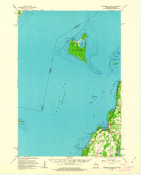 1961 Chambers Island1963 Print · USGSThe Door Peninsula and its surrounding islands are captured here in the early sixties, showing a maritime landscape of isolated lighthouses and small coastal settlements. Genealogists and local historians can locate St Johns Cem, Sunny Point Sch, and the Chambers Island Lighthouse.2 unique versions available
 - 1963 Map of Cedar River, 1964 Print
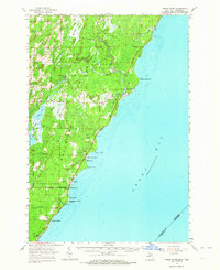 1963 Cedar River1964 Print · USGSThe Menominee County shoreline comes alive in the early 1960s, showing the quiet coastal settlements and timberlands along Green Bay. Researchers can trace family sites from Johnson Landing up to Cedar River, and locate landmarks like the Dominican House of Studies or the Cedar River Cem.3 unique versions available
 - 1963 Map of Birch Creek, 1964 Print
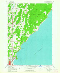 1963 Birch Creek1964 Print · USGSThe Menominee County shoreline comes alive in the early sixties as a mix of growing neighborhoods and rural outposts. Genealogists can trace family roots through several local landmarks like Evergreen Sch, Grant Sch, and the community at Birch Creek.2 unique versions available
 - 1963 Map of Stephenson, 1965 Print
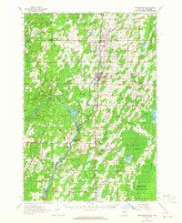 1963 Stephenson1965 Print · USGSThe Menominee River borderlands in the early sixties reveal a network of rail-side timber and farming towns. Genealogists can trace family roots at the Danish Cem, St Marks Ch, or the rural McAllister Sch near the Grand Rapids Dam.
 - 1963 Map of Marinette, 1965 Print
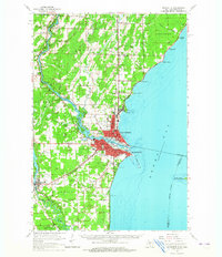 1963 Marinette1965 Print · USGSThe industrial twin cities of the Michigan-Wisconsin border are captured here in the early sixties, centered on the Menominee River and Green Bay coast. Genealogists and historians can trace rail lines, rural schoolhouses like Hamilton Sch, and family sites at Riverside Cem.
End of results
Showing maps 1-5 of 5
Top cities near Ingallston Township
- Marinette historical maps
- Menominee historical maps
- Peshtigo historical maps
- Porterfield historical maps
- Ingallston historical maps
- Stephenson historical maps
See more
Top neighborhoods of Ingallston Township
- Beach Grove historical maps
- Johnson Landing historical maps
- Arthur Bay historical maps
- Ingallston historical maps
Frequently asked questions
- What are the different types of historical maps available for Ingallston Township?
- What is the oldest map of Ingallston Township?
- Where can I purchase historical maps of Ingallston Township for my home or office?
- Where can I download high-res historical maps of Ingallston Township?
- Are there historical topographic maps available for Ingallston Township?
- Is there historical aerial imagery available for Ingallston Township?
- Where are historical maps of Ingallston Township sourced from?