Old Maps of Frenchtown Charter Township, Michigan for Metal Detecting
Plan your next treasure hunt with 56 historic maps of Frenchtown Charter Township. Find old homesites, ghost towns, trails, and gathering spots that may be lost to time — perfect for identifying promising metal detecting locations.
- Locate forgotten sites: Uncover places like long-lost settlements, abandoned rail lines, or gathering spots.
- Plan better hunts: Use map overlays combined with LiDAR or satellite views to narrow in on historically rich areas.
- Made for detectorists: Thousands of hobbyists use these maps to discover relics, coins, and hidden history.
Use these historic maps to boost your research and find new opportunities beneath the surface of Frenchtown Charter Township.
Frenchtown Charter Township, MI maps
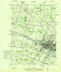
(56)- 1906 Map of Romulus
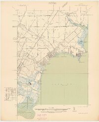
 1906 Romulus1906 Print · USGSSoutheast Michigan at the turn of the century shows a landscape defined by the winding Huron River and a dense network of competing steam and electric railways. Genealogists can trace early homesteads and rail stops in settlements like New Boston, Waltz, and the early crossroads at Carleton.2 unique versions available
 - 1912 Map of Monroe
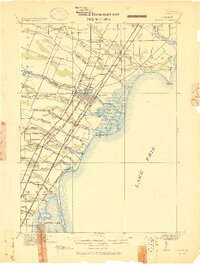 1912 Monroe1912 Print · USGSMonroe County before the First World War was a landscape defined by its strategic lakefront positioning and a massive concentration of competing railroads. Genealogists can trace the early footprints of Monroe, Brest P.O., and Erie while following local landmarks like Sandy Creek and Plum Creek.
 - 1914 Map of Monroe, 1928 Print
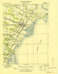 1914 Monroe1928 Print · USGSCoastal Michigan between Detroit and Toledo is shown here in the early twentieth century as a bustling hub of rail and river commerce. Genealogists and historians can trace the paths of six different railroads through Monroe and locate the old Brest Post Office near Point Aux Peaux.
 - 1927 Map of Monroe
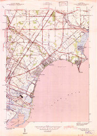
 1927 Monroe1927 Print · USGSMonroe and the surrounding Lake Erie shoreline are shown here during the late 1930s as a thriving industrial and rail corridor. Researchers can locate family landmarks like the Monroe Co Cem, Strasburg Sch, and the notable Monroe Co Infirmary.
 - 1928 Map of Romulus
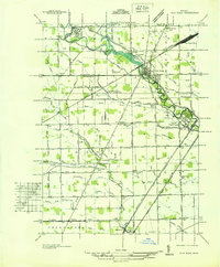
 1928 Romulus1928 Print · USGSSoutheast Michigan at the height of its rail-and-river era shows a dense network of transit lines and river towns. Genealogists can trace family roots through settlements like French Landing, Waltz, and South Rockwood or follow the path of the Pere Marquette RR.
 - 1936 Map of Stony Point
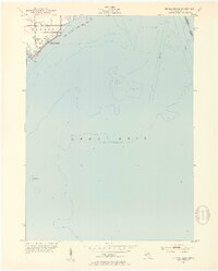
 1936 Stony Point1936 Print · USGSMonroe County’s Lake Erie shoreline was a burgeoning corridor of summer beaches and rail transport in the mid-1930s. Genealogists and researchers can trace family-named schools like Loranger Sch and Masserant Sch, or locate the historic St Charles Cem near Oldport.2 unique versions available
 - 1936 Map of Flat Rock
 1936 Flat Rock1936 Print · USGSSoutheast Michigan's riverfront and rail corridors are captured here in the mid-1930s as industrial yards and rural townships began to interface. Researchers can trace ancestral roots through dozens of local landmarks including Ash Center Cem, Maple Grove Sch, and the unique settlement at Scrabble.
 - 1936 Map of Carleton
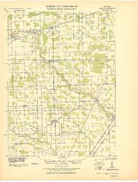
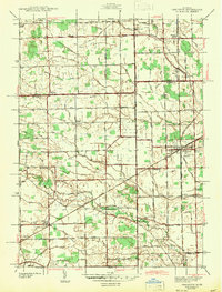
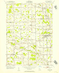
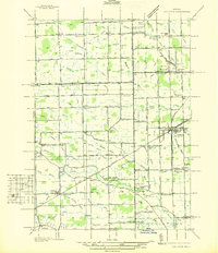 1936 Carleton1936 Print · USGSSoutheast Michigan farm country is captured here during the mid-thirties, showing the rural landscape surrounding the village of Carleton. Researchers can trace old family schoolhouses like Long Bridge Sch and early church sites including St Johns Ch along the Pere Marquette line.
 - 1942 Map of Flat Rock
 1942 Flat Rock1942 Print · USGSThe Detroit-Toledo corridor comes into focus just before the mid-century, where the Huron River meets a network of major railroads and early highways. Genealogists and local historians can trace rural schoolhouses like Bancroft Sch and Peters Sch, or locate family plots within Riverside Cem and Oakwood Cem.2 unique versions available
 - 1942 Map of Stony Point
 1942 Stony Point1942 Print · USGSMonroe County's Lake Erie shoreline was a thriving mix of coastal resorts and rail infrastructure in the 1940s. Researchers can trace family sites at St. Charles Cem, explore coastal developments like Woodland Beach, or locate rural landmarks like Scrabble Hollow Sch.2 unique versions available
 - 1942 Map of Monroe
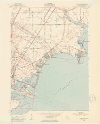
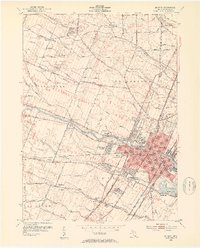
 1942 Monroe1942 Print · USGSMonroe and its riverfront townships are shown here in the early 1940s, revealing a busy rail corridor and the city's growth. Genealogists can trace family sites like Sandy Creek Cem, St Marys Academy, and the County Infirmary.2 unique versions available
 - 1942 Map of Estral Beach
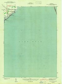 1942 Estral Beach1942 Print · USGSThe Monroe County shoreline comes into focus during the early 1940s, highlighting the coastal community at Estral Beach and its relationship with the lake. Genealogists and historians can trace local development in Berlin township along Langton Creek and Port Sunlight Rd.2 unique versions available
 - 1942 Map of Carleton
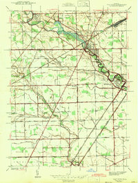
 1942 Carleton1942 Print · USGSMonroe and Wayne counties come into focus during the early 1940s, showing a landscape shaped by rail-line junctions and agricultural drains. Genealogists can trace family names through landmarks like Felt Cem, St Patricks Cem, and local schoolhouses like Willow Sch or Long Bridge Sch.2 unique versions available
 - 1952 Map of Estral Beach, 1953 Print
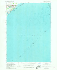
 1952 Estral Beach1953 Print · USGSThe Lake Erie shoreline in Monroe County was a mix of quiet beach communities and coastal wetlands during the early fifties. Genealogists and historians can trace the early layout of Estral Beach and locate landmarks like the Submerged Wreck and Swan Creek.2 unique versions available
 - 1952 Map of Stony Point, 1953 Print
 1952 Stony Point1953 Print · USGSThe western shores of Lake Erie show a bustling post-war era of beachside communities and industrial expansion near Monroe. Genealogists and local historians can trace the development of Woodland Beach, the grounds of Sterling State Park, and rural sites like Old St Charles Cem.2 unique versions available
 - 1952 Map of Flat Rock, 1953 Print
 1952 Flat Rock1953 Print · USGSThe Huron River valley in the early fifties shows a landscape of busy rail corridors and small-town growth. Trace family roots and local history through Michigan Memorial Park Cemetery, the Flat Rock Yard, and rural landmarks like Evergreen Cem.2 unique versions available
 - 1952 Map of Carleton, 1954 Print
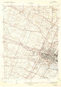
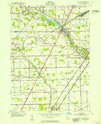
 1952 Carleton1954 Print · USGSThe crossroads of Wayne and Monroe Counties are captured here during a period of post-war rural transition. Researchers can trace family homesteads near landmarks like Felt Cem, the McGowan Sch, or the rail junction at Carleton.2 unique versions available
 - 1952 Map of Monroe, 1954 Print
 1952 Monroe1954 Print · USGSMonroe and its surrounding townships thrive in the early fifties as a hub of Lake Erie commerce and industry. Researchers can trace the layout of family neighborhoods and local landmarks like St Marys Academy, Tamarack, and the Custer Airport.2 unique versions available
 - 1954 Map of Detroit
 1954 Detroit1954 Print · USGSThe Detroit metro and its Ontario neighbors are shown at the height of the mid-century industrial era, just as the suburbs were rapidly expanding. Researchers can trace the massive rail networks of the Wabash Railroad or locate landmarks like Grosse Ile and Selfridge Air Force Base.
 - 1956 Map of Toledo, 1968 Print
 1956 Toledo1968 Print · USGSNorthwest Ohio and the Lake Erie shoreline are shown in detail during the late fifties, showcasing a landscape of heavy industry, railroads, and island communities. Genealogists and historians can trace rail networks like the Chesapeake & Ohio RR or locate landmarks such as the Erie Proving Ground and Kelleys Island.4 unique versions available
 - 1961 Map of Toledo
 1961 Toledo1961 Print · USGSThe western basin of Lake Erie and the industrial heart of Northern Ohio are captured here during the post-war era. Researchers can trace historical rail lines like the New York Central or locate landmarks like the Erie Ordnance Depot and Pelee Island.
 - 1961 Map of Detroit, 1973 Print
 1961 Detroit1973 Print · USGSThe international border between Michigan and Ontario was a bustling industrial corridor in the early sixties. Researchers can trace the transit networks and riverfront infrastructure connecting Detroit to Windsor via the Detroit-Windsor Tunnel and major air hubs like Willow Run Airport.2 unique versions available
 - 1965 Map of Detroit
 1965 Detroit1965 Print · USGSThe industrial corridor between Michigan and Ontario is captured here at mid-century, showing the dense rail and river networks of the Great Lakes. Local historians can trace the paths of the Grand Trunk Western RR and locate key landmarks like Selfridge Air Force Base and Grosse Ile.
 - 1967 Map of Estral Beach, 1969 Print
 1967 Estral Beach1969 Print · USGSThe western shores of Lake Erie come into focus in the late 1960s, showing the intersection of coastal marshlands and international shipping lanes. Trace the development of Estral Beach or locate early family holdings near Langton and the Pointe Mouillee State Game Area.2 unique versions available
 - 1967 Map of Monroe, 1969 Print
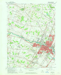 1967 Monroe1969 Print · USGSMonroe and its surrounding townships show a mix of industrial growth and rural tradition during the late sixties. Genealogists can trace family names through several burial grounds, including McIntyre Cem and Woodland Cem, while mapping the expansion of South Monroe.3 unique versions available
Showing maps 1-25 of 56
Top cities near Frenchtown Charter Township
- Toledo historical maps
- Taylor historical maps
- Ypsilanti Charter Township historical maps
- Brownstown Charter Township historical maps
- Bedford Township historical maps
- Van Buren Charter Township historical maps
See more
Top neighborhoods of Frenchtown Charter Township
- Steiner historical maps
- Stony Creek historical maps
- Pointe aux Peaux historical maps
- Golfcrest historical maps
- Detroit Beach historical maps
- Woodland Beach historical maps
See more
Frequently asked questions
- What are the different types of historical maps available for Frenchtown Charter Township?
- What is the oldest map of Frenchtown Charter Township?
- Where can I purchase historical maps of Frenchtown Charter Township for my home or office?
- Where can I download high-res historical maps of Frenchtown Charter Township?
- Are there historical topographic maps available for Frenchtown Charter Township?
- Is there historical aerial imagery available for Frenchtown Charter Township?
- Where are historical maps of Frenchtown Charter Township sourced from?