1950s Maps of Hiawatha Township, Michigan
Explore 10 historic maps of Hiawatha Township from the 1950s. These maps offer a rare glimpse into what life looked like during the 1950s — showing old roads, neighborhoods, homes, and landmarks that have changed or disappeared over time.
Whether you're researching your family's past, planning a metal detecting trip, or studying how Hiawatha Township's landscape evolved across the 1950s, these high-resolution maps are a powerful tool for exploring the history of this region.
- Focus on a specific era: All maps on this page are from the 1950s, giving you a focused view of this time period.
- See what’s changed: Compare century-old streets, trails, and buildings to today's modern landscape using overlays and satellite layers.
- Research with precision: Use these maps for genealogy, historical research, land use analysis, or educational projects.
- View, download, or print: Maps are fully viewable online in high resolution, and can be downloaded or printed for your own records.
Start exploring Hiawatha Township's history through authentic maps from the 1950s. This is your window into the past.
Hiawatha Township, MI maps
(10)- 1954 Map of Escanaba, 1967 Print
 1954 Escanaba1967 Print · USGSThe Upper Peninsula and Door County shorelines meet here in the mid-fifties, showing the vital maritime and timber networks of the Great Lakes. Researchers can trace historic rail lines, old fire lookouts like the Stonington Fire Tower, and island settlements such as Washington Island.2 unique versions available
 - 1957 Map of Escanaba
 1957 Escanaba1957 Print · USGSThe Upper Peninsula and Door County shorelines meet in the mid-fifties, capturing a landscape of timber, iron, and maritime trade. Genealogists and local historians can trace the Chicago & North Western RR through settlements like Hermansville or locate St Vitals Church and the Potawatome Indian Reservation.
 - 1958 Map of Escanaba
 1958 Escanaba1958 Print · USGSNorthern Lake Michigan maritime commerce and timberlands are captured here in the mid-fifties. Genealogists and historians can trace rail networks like the Escanaba and Lake Superior or locate island settlements such as Detroit Harbor and Fish Creek.
 - 1958 Map of Cooks, 1959 Print
 1958 Cooks1959 Print · USGSThe Upper Peninsula shoreline south of Manistique comes alive in the late fifties, showing a mix of timber forest and new beach settlements. Trace family sites at Cooks Cem, locate the Cooks Lookout Tower, and follow the Garden Trail through the woods.
 - 1958 Map of Corner Lake, 1959 Print
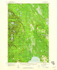
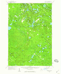 1958 Corner Lake1959 Print · USGSIn Michigan's Upper Peninsula during the late fifties, this wilderness terrain was a hub for forestry and seasonal camps within the Hiawatha National Forest. Researchers can locate the settlement of Steuben, trace the Railroad Grade, or identify isolated sites like Camp Twenty-six and the Petoskey Hunting Club.2 unique versions available
 - 1958 Map of Munising, 1959 Print
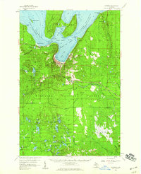 1958 Munising1959 Print · USGSThe Lake Superior shoreline near Munising is captured here in the late fifties, showcasing the area's timber and transport roots. Genealogists and researchers can trace local landmarks like Maple Grove Cem, the Hanely Landing Field, and the rail junction at Coalwood.3 unique versions available
 - 1958 Map of Shingleton, 1959 Print
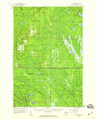 1958 Shingleton1959 Print · USGSUpper Peninsula timber and rail history come alive in the late fifties across the Alger and Schoolcraft county lines. Trace old transport routes through Shingleton and Creighton, or locate logging era sites like Hartman Camp and the Old Railroad Grade.3 unique versions available
 - 1958 Map of Grand Portal Point, 1959 Print
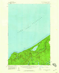 1958 Grand Portal Point1959 Print · USGSThe Lake Superior shoreline in the late fifties reveals a wilderness of dramatic coastal features and inland lakes. Researchers can trace the drainage of the Mosquito River and locate landmarks like Chapel Rock and the Buck Hill Lookout Tower.2 unique versions available
 - 1958 Map of Steuben, 1959 Print
 1958 Steuben1959 Print · USGSIn the central Upper Peninsula during the late fifties, this wilderness landscape shows the intersection of conservation and industry. Trace the remote settlement of Steuben, the Hiawatha (Station), and the fire-watching height of the Steuben Lookout Tower.2 unique versions available
 - 1958 Map of Marquette, 1968 Print
 1958 Marquette1968 Print · USGSThe Upper Peninsula’s central corridor is captured here in the mid-twentieth century as mining and timber industries thrived alongside new military installations. Genealogists and historians can trace the rail lines of the Soo Line Railroad through settlements like Gwinn, Turin, and Chatham.2 unique versions available
End of results
Showing maps 1-10 of 10
Top cities near Hiawatha Township
Top neighborhoods of Hiawatha Township
- Copenhagen Beach historical maps
- Harrison Beach historical maps
- Cusino historical maps
- Ossawinamakee Beach historical maps
- Pines historical maps
- Creighton historical maps
See more
Frequently asked questions
- What are the different types of historical maps available for Hiawatha Township?
- What is the oldest map of Hiawatha Township?
- Where can I purchase historical maps of Hiawatha Township for my home or office?
- Where can I download high-res historical maps of Hiawatha Township?
- Are there historical topographic maps available for Hiawatha Township?
- Is there historical aerial imagery available for Hiawatha Township?
- Where are historical maps of Hiawatha Township sourced from?