1990s Maps of Detroit, Michigan
Explore 2 historic maps of Detroit from the 1990s. These maps offer a rare glimpse into what life looked like during the 1990s — showing old roads, neighborhoods, homes, and landmarks that have changed or disappeared over time.
Whether you're researching your family's past, planning a metal detecting trip, or studying how Detroit's landscape evolved across the 1990s, these high-resolution maps are a powerful tool for exploring the history of this region.
- Focus on a specific era: All maps on this page are from the 1990s, giving you a focused view of this time period.
- See what’s changed: Compare century-old streets, trails, and buildings to today's modern landscape using overlays and satellite layers.
- Research with precision: Use these maps for genealogy, historical research, land use analysis, or educational projects.
- View, download, or print: Maps are fully viewable online in high resolution, and can be downloaded or printed for your own records.
Start exploring Detroit's history through authentic maps from the 1990s. This is your window into the past.
Detroit, MI maps
(2)- 1996 Map of Royal Oak, 2000 Print
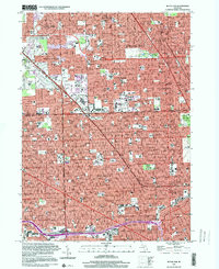 1996 Royal Oak2000 Print · USGSThe northern Detroit suburbs and the Oakland County line come into focus during the late twentieth century. Genealogists and local historians can trace parish landmarks like St Mary of Redford High Sch or major sites like Woodlawn Cemetery and Northland Shopping Center.
 - 1996 Map of Inkster, 2000 Print
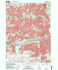 1996 Inkster2000 Print · USGSThe suburban heart of Wayne County comes into focus in the mid-nineties, showing the fully developed neighborhoods and river parkways of Westland and Garden City. Trace local history through landmarks like Nankin Mills, the St Bernard Seminary, and numerous family-named parks and parish schools.
End of results
Showing maps 1-2 of 2
Top cities near Detroit
- Sterling Heights historical maps
- Warren historical maps
- Clinton Township historical maps
- Livonia historical maps
- Dearborn historical maps
- Troy historical maps
See more
Top neighborhoods of Detroit
- Oak historical maps
- Delray Junction historical maps
- New Center historical maps
- Midtown historical maps
- Warrendale historical maps
- Northwest Detroit historical maps
See more
Frequently asked questions
- What are the different types of historical maps available for Detroit?
- What is the oldest map of Detroit?
- Where can I purchase historical maps of Detroit for my home or office?
- Where can I download high-res historical maps of Detroit?
- Are there historical topographic maps available for Detroit?
- Is there historical aerial imagery available for Detroit?
- Where are historical maps of Detroit sourced from?