1960s Maps of Detroit, Michigan
Explore 10 historic maps of Detroit from the 1960s. These maps offer a rare glimpse into what life looked like during the 1960s — showing old roads, neighborhoods, homes, and landmarks that have changed or disappeared over time.
Whether you're researching your family's past, planning a metal detecting trip, or studying how Detroit's landscape evolved across the 1960s, these high-resolution maps are a powerful tool for exploring the history of this region.
- Focus on a specific era: All maps on this page are from the 1960s, giving you a focused view of this time period.
- See what’s changed: Compare century-old streets, trails, and buildings to today's modern landscape using overlays and satellite layers.
- Research with precision: Use these maps for genealogy, historical research, land use analysis, or educational projects.
- View, download, or print: Maps are fully viewable online in high resolution, and can be downloaded or printed for your own records.
Start exploring Detroit's history through authentic maps from the 1960s. This is your window into the past.
Detroit, MI maps
(10)- 1961 Map of Detroit, 1973 Print
 1961 Detroit1973 Print · USGSThe international border between Michigan and Ontario was a bustling industrial corridor in the early sixties. Researchers can trace the transit networks and riverfront infrastructure connecting Detroit to Windsor via the Detroit-Windsor Tunnel and major air hubs like Willow Run Airport.2 unique versions available
 - 1965 Map of Detroit
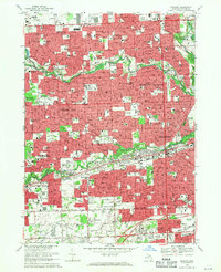
 1965 Detroit1965 Print · USGSThe industrial corridor between Michigan and Ontario is captured here at mid-century, showing the dense rail and river networks of the Great Lakes. Local historians can trace the paths of the Grand Trunk Western RR and locate key landmarks like Selfridge Air Force Base and Grosse Ile.
 - 1968 Map of Inkster, 1970 Print
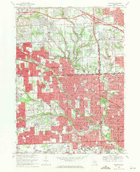
 1968 Inkster1970 Print · USGSThe suburban heart of Wayne County comes alive in this late-sixties study of the Rouge River valley. Researchers can trace the mid-century development of Livonia and Garden City, locating long-standing community markers like the Eloise Cem and Nankin Mills Sch.3 unique versions available
 - 1968 Map of Dearborn, 1970 Print
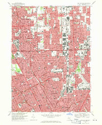
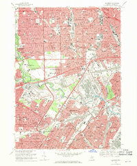 1968 Dearborn1970 Print · USGSMid-century Dearborn and West Detroit are captured here at a peak of industrial and suburban development. Genealogists and local historians can locate dozens of neighborhood parish schools, the Evergreen Cem, and the iconic Greenfield Village grounds.4 unique versions available
 - 1968 Map of Belle Isle, 1971 Print
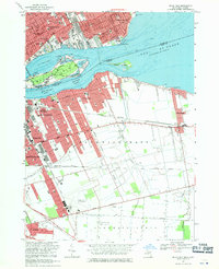 1968 Belle Isle1971 Print · USGSThe international border at the Detroit River comes alive in the late sixties, showing the vibrant connection between Michigan and Ontario. Genealogists and historians can trace the neighborhoods of Walkerville and Grosse Pointe Park or locate landmarks like the Detroit Yacht Club and Southeastern High Sch.3 unique versions available
 - 1968 Map of Grosse Pointe, 1971 Print
 1968 Grosse Pointe1971 Print · USGSThe Grosse Pointe shoreline and Detroit's eastern neighborhoods are shown here in the late sixties, just as modern shopping centers and residential grids were fully established. Genealogists and local historians can locate early burial sites like Mt Calvary Sch Cem and landmarks such as the Grosse Pointe Yacht Club and Chandler Park.4 unique versions available
 - 1968 Map of Royal Oak, 1971 Print
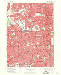 1968 Royal Oak1971 Print · USGSDetroit and its northern suburbs reached a peak of mid-century development as seen in this late-sixties survey. Researchers can trace the growth of Oak Park and Ferndale or locate family landmarks like Woodlawn Cemetery and St Gerard Sch.4 unique versions available
 - 1968 Map of Detroit, 1971 Print
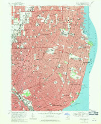
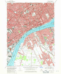 1968 Detroit1971 Print · USGSThe Detroit and Windsor riverfronts meet in this late-sixties survey of the international border. Genealogists and historians can trace urban landmarks like Elmwood Cemetery, the U S Mil Res, and the storied grounds of Tiger Stadium.4 unique versions available
 - 1968 Map of Redford, 1971 Print
 1968 Redford1971 Print · USGSRedford and northwest Detroit emerge in their mid-century form as the suburban grid solidifies along the county line. Genealogists can trace family sites near Holy Sepulchre Cemetery, Clarenceville Cem, and numerous parish schools like St Paul Sch.4 unique versions available
 - 1968 Map of Highland Park, 1971 Print
 1968 Highland Park1971 Print · USGSThe northern Detroit metropolitan area is shown here in its mid-century maturity, featuring the densely packed street grids of industrial enclaves. Genealogists can trace family neighborhoods near Mt Olivet Cem, St Florian High Sch, or along the Grand Trunk Western RR.4 unique versions available
End of results
Showing maps 1-10 of 10
Top cities near Detroit
- Sterling Heights historical maps
- Warren historical maps
- Clinton Township historical maps
- Livonia historical maps
- Dearborn historical maps
- Troy historical maps
See more
Top neighborhoods of Detroit
- Oak historical maps
- Delray Junction historical maps
- New Center historical maps
- Midtown historical maps
- Warrendale historical maps
- Northwest Detroit historical maps
See more
Frequently asked questions
- What are the different types of historical maps available for Detroit?
- What is the oldest map of Detroit?
- Where can I purchase historical maps of Detroit for my home or office?
- Where can I download high-res historical maps of Detroit?
- Are there historical topographic maps available for Detroit?
- Is there historical aerial imagery available for Detroit?
- Where are historical maps of Detroit sourced from?