1910s Maps of Aitkin County, Minnesota
Explore 7 historic maps of Aitkin County from the 1910s. These maps offer a rare glimpse into what life looked like during the 1910s — showing old roads, neighborhoods, homes, and landmarks that have changed or disappeared over time.
Whether you're researching your family's past, planning a metal detecting trip, or studying how Aitkin County's landscape evolved across the 1910s, these high-resolution maps are a powerful tool for exploring the history of this region.
- Focus on a specific era: All maps on this page are from the 1910s, giving you a focused view of this time period.
- See what’s changed: Compare century-old streets, trails, and buildings to today's modern landscape using overlays and satellite layers.
- Research with precision: Use these maps for genealogy, historical research, land use analysis, or educational projects.
- View, download, or print: Maps are fully viewable online in high resolution, and can be downloaded or printed for your own records.
Start exploring Aitkin County's history through authentic maps from the 1910s. This is your window into the past.
Aitkin County, MN maps
(7)- 1912 Map of Deerwood, 1963 Print
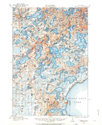 1912 Deerwood1963 Print · USGSIn the decade before the region's full industrialization, this survey captures the lake-country settlements of Deerwood and Crosby just as the Northern Pacific railroad was driving local growth. Genealogists can locate dozens of early district schools and local landmarks like Doris Church and Katrine School.2 unique versions available
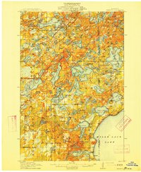
 - 1913 Map of Cuyuna, 1963 Print
 1913 Cuyuna1963 Print · USGSBefore the height of northern Minnesota's iron boom, this area centered on the nascent village of Cuyuna and the logging town of Emily. Genealogists and researchers can trace the early township school system through sites like Mud Brook School and Keeler School, or follow the competing routes of the Northern Pacific and Minneapolis St Paul and Sault Ste Marie railroads.2 unique versions available
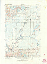
 - 1914 Map of Deerwood
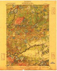
 1914 Deerwood1914 Print · USGSCrow Wing and Aitkin counties are captured here just before the First World War, showing the growth of iron range towns and lakeside settlements. Genealogists and researchers can trace early rural life through nearly twenty numbered schoolhouses, the Dorris Church, and railroad stops at Crosby and Ironton.3 unique versions available
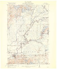
 - 1914 Map of Aitkin, 1966 Print
 1914 Aitkin1966 Print · USGSAitkin and the surrounding wetlands are shown here just before the First World War, as the river-and-rail economy shaped the landscape. Genealogists can locate numerous rural schoolhouses and early settlements like Rossburg, Hassman, and the Lone Pine School.
 - 1915 Map of Aitkin
 1915 Aitkin1915 Print · USGSAitkin County in the mid-1910s was a hub of river transport and rail expansion, centered on the growing village of Aitkin. You can trace the path of the Northern Pacific railroad through Rossburg and find rural landmarks like Lone Pine School and Waukenabo Lake.4 unique versions available
 - 1915 Map of Cuyuna
 1915 Cuyuna1915 Print · USGSCrow Wing and Aitkin counties are captured here just before the First World War, as railroads and mining began to transform the lake-heavy landscape. Genealogists can locate many numbered district schools and settlements like Emily, Manganese, and Dean Lake.3 unique versions available
 - 1916 Map of Wealthwood
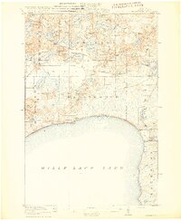 1916 Wealthwood1916 Print · USGSThe north shore of Mille Lacs Lake is captured in the mid-1910s during a period of rural schoolhouse expansion and early shoreline settlement. Genealogists can locate family landmarks like Carlson School, the Town Hall, and pioneer hubs at Wealthwood or Malmo.4 unique versions available
End of results
Showing maps 1-7 of 7
Top cities of Aitkin County
- Aitkin historical maps
- Hill City historical maps
- Glen historical maps
- McGregor historical maps
- Waukenabo historical maps
- Malmo historical maps
See more
Frequently asked questions
- What are the different types of historical maps available for Aitkin County?
- What is the oldest map of Aitkin County?
- Where can I purchase historical maps of Aitkin County for my home or office?
- Where can I download high-res historical maps of Aitkin County?
- Are there historical topographic maps available for Aitkin County?
- Is there historical aerial imagery available for Aitkin County?
- Where are historical maps of Aitkin County sourced from?