1980s Maps of Cook County, Minnesota
Explore 6 historic maps of Cook County from the 1980s. These maps offer a rare glimpse into what life looked like during the 1980s — showing old roads, neighborhoods, homes, and landmarks that have changed or disappeared over time.
Whether you're researching your family's past, planning a metal detecting trip, or studying how Cook County's landscape evolved across the 1980s, these high-resolution maps are a powerful tool for exploring the history of this region.
- Focus on a specific era: All maps on this page are from the 1980s, giving you a focused view of this time period.
- See what’s changed: Compare century-old streets, trails, and buildings to today's modern landscape using overlays and satellite layers.
- Research with precision: Use these maps for genealogy, historical research, land use analysis, or educational projects.
- View, download, or print: Maps are fully viewable online in high resolution, and can be downloaded or printed for your own records.
Start exploring Cook County's history through authentic maps from the 1980s. This is your window into the past.
Cook County, MN maps
(6)- 1981 Map of Toohey Lake, 1982 Print
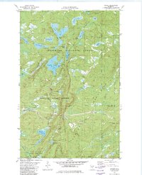
 1981 Toohey Lake1982 Print · USGSCook County's deep woods and glacial waters are captured here in the early 1980s within the Superior National Forest. Trace the waterways of Fourmile Lake, the course of the Temperance River, and the heights of Honeymoon Mountain.
 - 1981 Map of Cramer, 1982 Print
 1981 Cramer1982 Print · USGSThe Sawtooth Mountains of Lake County are captured here in the early 1980s, showing a rugged landscape shaped by forestry and transit. Local historians can trace the Mining Railroad near Cramer or locate the old grades around Pearl Lake and Hare Lake.2 unique versions available
 - 1981 Map of Honeymoon Mountain, 1982 Print
 1981 Honeymoon Mountain1982 Print · USGSThe North Shore highlands come into focus in the early eighties, showing a landscape defined by timber and topography. You can trace the Railroad Grade and Honeymoon Trail through the Sawtooth Mountains past Pancore Lake and Oberg Mountain.
 - 1981 Map of Wilson Lake, 1982 Print
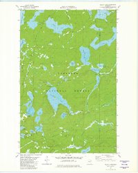 1981 Wilson Lake1982 Print · USGSLake County and Cook County meet in this northern forest during the early eighties, where a dense network of glacial lakes and river systems defines the landscape. Historians and outdoor enthusiasts can trace the Old Railroad Grade and find remote water bodies like Elbow Lake and Dam Five Lake.2 unique versions available
 - 1985 Map of Pigeon Point
 1985 Pigeon Point1985 Print · USGSThe Minnesota-Canada borderlands meet Lake Superior in the mid-1980s at this remote northern tip of Cook County. Researchers can trace the international line along the Pigeon River and explore the coastal boundaries of Grand Portage State Forest and Isle Royale National Park.2 unique versions available
 - 1985 Map of Grand Portage
 1985 Grand Portage1985 Print · USGSThe international border along Lake Superior is shown in detail during the mid-1980s, bridging the wilderness of Minnesota and Michigan. Researchers can trace the varied terrain of Isle Royale National Park and the lakeside settlements of Hovland and Mineral Center.2 unique versions available
End of results
Showing maps 1-6 of 6
Top cities of Cook County
Frequently asked questions
- What are the different types of historical maps available for Cook County?
- What is the oldest map of Cook County?
- Where can I purchase historical maps of Cook County for my home or office?
- Where can I download high-res historical maps of Cook County?
- Are there historical topographic maps available for Cook County?
- Is there historical aerial imagery available for Cook County?
- Where are historical maps of Cook County sourced from?