1970s Maps of Cook County, Minnesota
Explore 5 historic maps of Cook County from the 1970s. These maps offer a rare glimpse into what life looked like during the 1970s — showing old roads, neighborhoods, homes, and landmarks that have changed or disappeared over time.
Whether you're researching your family's past, planning a metal detecting trip, or studying how Cook County's landscape evolved across the 1970s, these high-resolution maps are a powerful tool for exploring the history of this region.
- Focus on a specific era: All maps on this page are from the 1970s, giving you a focused view of this time period.
- See what’s changed: Compare century-old streets, trails, and buildings to today's modern landscape using overlays and satellite layers.
- Research with precision: Use these maps for genealogy, historical research, land use analysis, or educational projects.
- View, download, or print: Maps are fully viewable online in high resolution, and can be downloaded or printed for your own records.
Start exploring Cook County's history through authentic maps from the 1970s. This is your window into the past.
Cook County, MN maps
(5)- 1976 Map of Two Harbors, 1994 Print
 1976 Two Harbors1994 Print · USGSThe North Shore of Lake Superior comes alive in this mid-seventies survey of the Minnesota timber and iron country. Trace the Duluth Missabe and Iron Range RR from Two Harbors past Split Rock Lighthouse State Park to the industrial port at Silver Bay.
 - 1976 Map of Saganaga Lake, 1994 Print
 1976 Saganaga Lake1994 Print · USGSCook County's border with Canada remained a wilderness of interconnected lakes and timberland in the mid-seventies. Researchers can trace historic travel routes along the Gunflint Trail and locate former fire watch sites like the Gunflint Lookout Tower.
 - 1977 Map of Basswood Lake, 1994 Print
 1977 Basswood Lake1994 Print · USGSThe Boundary Waters and Ontario’s wilderness meet in the late seventies across a vast network of interconnected glacial lakes. Researchers can trace the international line through Basswood Lake, Crooked Lake, and around the massive Hunter Island.
 - 1977 Map of Grand Marais, 1994 Print
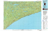 1977 Grand Marais1994 Print · USGSThe North Shore of Lake Superior comes into focus in the mid-1970s, showing a landscape defined by timber, tourism, and lakefront life. Researchers can trace local landmarks like the Grand Marais Lighthouse, the Cathedral of the Pines, and the coastal docks at Taconite Harbor.
 - 1978 Map of Outer Island
 1978 Outer Island1978 Print · USGSThe Apostle Islands archipelago and the vast expanse of Lake Superior are shown in the late seventies. Researchers can trace maritime landmarks like the Outer Island Light, explore island terrain from Bear Island to Cat Island, and locate the old Landing Strip.
End of results
Showing maps 1-5 of 5
Top cities of Cook County
Frequently asked questions
- What are the different types of historical maps available for Cook County?
- What is the oldest map of Cook County?
- Where can I purchase historical maps of Cook County for my home or office?
- Where can I download high-res historical maps of Cook County?
- Are there historical topographic maps available for Cook County?
- Is there historical aerial imagery available for Cook County?
- Where are historical maps of Cook County sourced from?