1970s Maps of Kittson County, Minnesota
Explore 16 historic maps of Kittson County from the 1970s. These maps offer a rare glimpse into what life looked like during the 1970s — showing old roads, neighborhoods, homes, and landmarks that have changed or disappeared over time.
Whether you're researching your family's past, planning a metal detecting trip, or studying how Kittson County's landscape evolved across the 1970s, these high-resolution maps are a powerful tool for exploring the history of this region.
- Focus on a specific era: All maps on this page are from the 1970s, giving you a focused view of this time period.
- See what’s changed: Compare century-old streets, trails, and buildings to today's modern landscape using overlays and satellite layers.
- Research with precision: Use these maps for genealogy, historical research, land use analysis, or educational projects.
- View, download, or print: Maps are fully viewable online in high resolution, and can be downloaded or printed for your own records.
Start exploring Kittson County's history through authentic maps from the 1970s. This is your window into the past.
Kittson County, MN maps
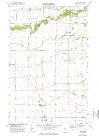
(16)- 1971 Map of Bowesmont, 1973 Print
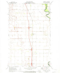 1971 Bowesmont1973 Print · USGSPembina County at the start of the 1970s reveals a landscape defined by the winding North Red River and a growing highway system. Local historians can trace the rail-and-road corridor through Bowesmont, Pittsburg, and the Burlington Northern line.2 unique versions available
 - 1971 Map of Drayton, 1973 Print
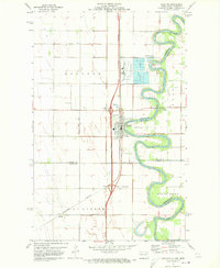 1971 Drayton1973 Print · USGSThe Red River valley in the early 1970s reveals a landscape of fertile farmland and river-dependent industry. Researchers can trace the rail lines of the Burlington Northern through Drayton and locate family landmarks like Drayton Cem and Herrick.2 unique versions available
 - 1972 Map of Joliette, 1974 Print
 1972 Joliette1974 Print · USGSThe Red River Valley in the early 1970s is shown here as a grid of industrial agriculture and modern transit corridors. Genealogists and local historians can trace the development of Joliette and Mc Arthur or locate rural landmarks like Townhall and Fleece.2 unique versions available
 - 1972 Map of Pembina, 1974 Print
 1972 Pembina1974 Print · USGSThe Red River valley at the international border was a bustling transit hub in the early seventies. Genealogists and local historians can trace the border infrastructure at Noyes and locate rural landmarks like Lutheran Cem and St Vincent.2 unique versions available
 - 1974 Map of Donaldson, 1976 Print
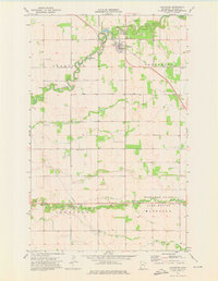
 1974 Donaldson1976 Print · USGSNorthwestern Minnesota's Red River Valley agricultural grid is mapped in the mid-seventies, showing the intersection of rail and rural life. Researchers can locate the Hillcrest Cem, the local Townhall, and the drainage network of Judicial Ditch No 3.
 - 1974 Map of Humboldt, 1976 Print
 1974 Humboldt1976 Print · USGSThe northern reaches of Kittson County are captured here in the mid-1970s, where rail lines and river drainage define the borderland prairie. Genealogists and historians can locate the North Star Ch, the local Cem, and the rail junction at Humboldt.
 - 1974 Map of Kennedy, 1976 Print
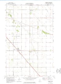
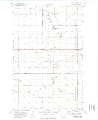
 1974 Kennedy1976 Print · USGSKennedy and the surrounding Kittson County townships appear here during the mid-seventies, showing a landscape defined by rail and drainage. Genealogists and local historians can trace the bounds of Skane and Tegner, locate Hope Cem, or find the old Drive-in Theater.
 - 1974 Map of Hallock NE, 1976 Print
 1974 Hallock NE1976 Print · USGSKittson County's northern borderlands are captured here in the mid-seventies, showing the intersection of international transit and prairie drainage. Locate local landmarks like Holy Rosary Ch, Sikar Cem, and the diagonal tracks of the Soo Line.
 - 1974 Map of Mattson, 1976 Print
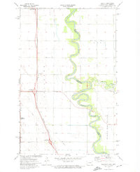
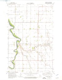 1974 Mattson1976 Print · USGSKittson County's river-driven landscape is captured here in the mid-1970s as the Red River snakes along the state border. Researchers can locate the rural hub of Mattson, the Tabitha Ch cemetery, and the Townhall in Skane.
 - 1974 Map of Hill Siding, 1976 Print
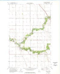 1974 Hill Siding1976 Print · USGSKittson County agriculture and rail transport intersect in the mid-seventies near the North Dakota border. Researchers can trace the path of the Burlington Northern through Northcote or follow the winding North Branch Two Rivers.
 - 1974 Map of Orleans, 1976 Print
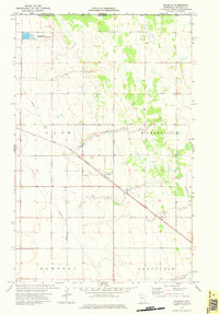 1974 Orleans1976 Print · USGSKittson County sits along the international border in the 1970s, where the prairie meets the Canadian line. Trace the SOO LINE rail route through Orleans and locate the water resources of the Little Joe River and Joe River State Wildlife Area.
 - 1974 Map of Hallock, 1976 Print
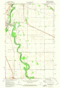
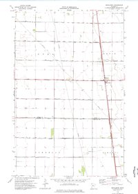
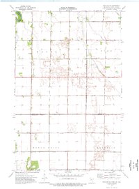
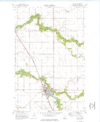 1974 Hallock1976 Print · USGSThe Red River Valley prairie of the mid-1970s is meticulously captured here, showing the Kittson County seat at a moment of established growth. Genealogists and local historians can trace family locations near Northcote, Greenwood Cem, or the many farmsteads along the Burlington Northern line.
 - 1974 Map of Enok, 1976 Print
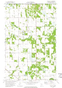
 1974 Enok1976 Print · USGSKittson County in the mid-seventies remains a landscape defined by its winding waterways and scattered rural townships. Genealogists can trace family roots through sites like West Emmaus Cem, Jupiter Mission Cem, and the small settlement of Enok.
 - 1974 Map of Kennedy SE, 1976 Print
 1974 Kennedy SE1976 Print · USGSKittson and Marshall Counties are captured here in the mid-1970s, showcasing a rural landscape shaped by intensive drainage and family farmsteads. Researchers can locate specific sites like St Petri Ch, Spring Brook Cem, and the waters of Andreason Lake.
 - 1974 Map of Drayton SE, 1976 Print
 1974 Drayton SE1976 Print · USGSThe Red River Valley in the mid-seventies reveals a vast agricultural landscape defined by its intricate drainage networks and rural townships. Genealogists and local historians can trace the foundations of the community through sites like Skjeberg Ch, the Townhall, and several named irrigation channels.
 - 1974 Map of Lancaster, 1976 Print
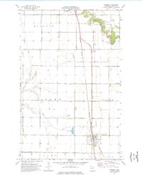
 1974 Lancaster1976 Print · USGSIn the mid-1970s, the rural landscape of Kittson County centered on the railroad town of Lancaster and its surrounding agricultural townships. Genealogists and local historians can trace family locations through several burial grounds, including Saron Cem and Bethlehem Cem, or follow the path of the Soo Line.
End of results
Showing maps 1-16 of 16
Top cities of Kittson County
- Hallock historical maps
- Karlstad historical maps
- Lancaster historical maps
- Kennedy historical maps
- Lake Bronson historical maps
- Deerwood historical maps
See more
Frequently asked questions
- What are the different types of historical maps available for Kittson County?
- What is the oldest map of Kittson County?
- Where can I purchase historical maps of Kittson County for my home or office?
- Where can I download high-res historical maps of Kittson County?
- Are there historical topographic maps available for Kittson County?
- Is there historical aerial imagery available for Kittson County?
- Where are historical maps of Kittson County sourced from?