1960s Maps of Kittson County, Minnesota
Explore 7 historic maps of Kittson County from the 1960s. These maps offer a rare glimpse into what life looked like during the 1960s — showing old roads, neighborhoods, homes, and landmarks that have changed or disappeared over time.
Whether you're researching your family's past, planning a metal detecting trip, or studying how Kittson County's landscape evolved across the 1960s, these high-resolution maps are a powerful tool for exploring the history of this region.
- Focus on a specific era: All maps on this page are from the 1960s, giving you a focused view of this time period.
- See what’s changed: Compare century-old streets, trails, and buildings to today's modern landscape using overlays and satellite layers.
- Research with precision: Use these maps for genealogy, historical research, land use analysis, or educational projects.
- View, download, or print: Maps are fully viewable online in high resolution, and can be downloaded or printed for your own records.
Start exploring Kittson County's history through authentic maps from the 1960s. This is your window into the past.
Kittson County, MN maps
(7)- 1966 Map of Skull Lake, 1967 Print
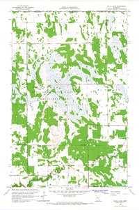 1966 Skull Lake1967 Print · USGSSettled along the Manitoba border in the mid-sixties, this Kittson County landscape shows a network of drainage ditches and conservation lands. Trace local history at McKinley Cem, the First Lutheran Ch, and the banks of the North Branch Two Rivers.
 - 1966 Map of Caribou, 1967 Print
 1966 Caribou1967 Print · USGSThe Minnesota-Manitoba border comes into focus in the mid-1960s, showing the remote northern reaches of Kittson County. Genealogists and local historians can locate the Caribou settlement and its Cem, or trace the engineering of Judicial Ditch No 32.
 - 1966 Map of Skull Lake NE, 1967 Print
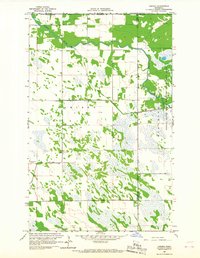
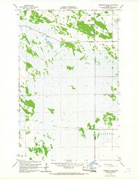
 1966 Skull Lake NE1967 Print · USGSThe northern edge of Kittson County meets the Canadian border in the mid-1960s, showing a landscape defined by township lines and drainage projects. Researchers can trace the extensive network of engineered waterways, including State Ditch No 84 and County Ditch No 14, through McKinley and Caribou.
 - 1966 Map of Skull Lake SE, 1967 Print
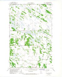
 1966 Skull Lake SE1967 Print · USGSThe northwestern Minnesota wetlands are seen here in the mid-1960s, showing a landscape transformed by large-scale drainage efforts. Researchers can trace the engineering of the prairie through Judicial Ditch No 31 and across the townships of Cannon and Percy.
 - 1966 Map of Juneberry Ridge, 1967 Print
 1966 Juneberry Ridge1967 Print · USGSThe borderlands of Kittson and Roseau counties are shown here in the mid-sixties, dominated by agricultural drainage networks. Genealogists and researchers can trace the settlement of Polonia or locate old landmarks like Juneberry Ridge and Moose Point.2 unique versions available
 - 1966 Map of Skull Lake SW, 1967 Print
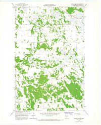
 1966 Skull Lake SW1967 Print · USGSNorthwestern Minnesota's agricultural landscape is captured here in the mid-1960s, showing a region defined by extensive drainage projects and the Soo Line. Researchers can trace the Middle Branch Two Rivers alongside local Townhall locations and several Sandpit operations.
 - 1967 Map of Thief River Falls
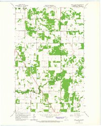
 1967 Thief River Falls1967 Print · USGSThe Red River Valley and the international border come alive in the 1960s, showing a landscape shaped by major rail lines and river commerce. Genealogists and historians can trace the paths of the Great Northern and Soo Line through towns like Thief River Falls, Grafton, and Hallock.
End of results
Showing maps 1-7 of 7
Top cities of Kittson County
- Hallock historical maps
- Karlstad historical maps
- Lancaster historical maps
- Kennedy historical maps
- Lake Bronson historical maps
- Deerwood historical maps
See more
Frequently asked questions
- What are the different types of historical maps available for Kittson County?
- What is the oldest map of Kittson County?
- Where can I purchase historical maps of Kittson County for my home or office?
- Where can I download high-res historical maps of Kittson County?
- Are there historical topographic maps available for Kittson County?
- Is there historical aerial imagery available for Kittson County?
- Where are historical maps of Kittson County sourced from?