1980s Maps of Kittson County, Minnesota
Explore 8 historic maps of Kittson County from the 1980s. These maps offer a rare glimpse into what life looked like during the 1980s — showing old roads, neighborhoods, homes, and landmarks that have changed or disappeared over time.
Whether you're researching your family's past, planning a metal detecting trip, or studying how Kittson County's landscape evolved across the 1980s, these high-resolution maps are a powerful tool for exploring the history of this region.
- Focus on a specific era: All maps on this page are from the 1980s, giving you a focused view of this time period.
- See what’s changed: Compare century-old streets, trails, and buildings to today's modern landscape using overlays and satellite layers.
- Research with precision: Use these maps for genealogy, historical research, land use analysis, or educational projects.
- View, download, or print: Maps are fully viewable online in high resolution, and can be downloaded or printed for your own records.
Start exploring Kittson County's history through authentic maps from the 1980s. This is your window into the past.
Kittson County, MN maps
(8)- 1982 Map of Pelan
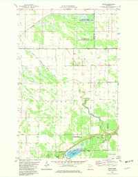 1982 Pelan1982 Print · USGSNorthwestern Minnesota in the early eighties was defined by its vast conservation areas and complex drainage networks. Genealogists and local historians can trace the settlement of Pelan and find the Pioneer Cem near the South Branch Two Rivers.
 - 1982 Map of Karlstad
 1982 Karlstad1982 Print · USGSKarlstad and the borderlands of Kittson and Marshall Counties are captured here in the early eighties as a landscape of rail-driven commerce and organized drainage. Genealogists can locate family sites at Lundeby Cem or Hegland Ch and trace the winding Tamarac River.
 - 1982 Map of Twistal Swamp
 1982 Twistal Swamp1982 Print · USGSThe marshlands of Kittson County are captured here in the early eighties, showing a landscape defined by the drainage of Twistal Swamp. Local researchers can locate community anchors like the Zion Ch and Townhall alongside the winding Tamarac River.
 - 1982 Map of Karlstad SW
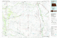
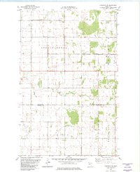 1982 Karlstad SW1982 Print · USGSKittson County farm country at the dawn of the 1980s reveals a landscape of strictly ordered township grids and drainage canals. Genealogists and local historians can locate the Oslo Cem, find the local Townhall, and trace the boundaries of Spring Brook and Augsburg.2 unique versions available
 - 1982 Map of Lake Bronson
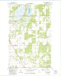
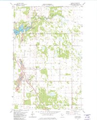
 1982 Lake Bronson1982 Print · USGSKittson County's agricultural heartland is documented here in the early eighties, centered on the confluence of prairie and parkland. Researchers can locate the East Emmaus Ch, Riverside Cem, and the early layout of Lake Bronson State Park.
 - 1982 Map of Halma
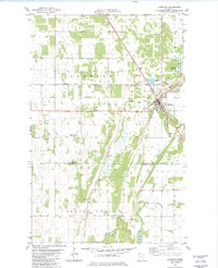
 1982 Halma1982 Print · USGSThe northern Minnesota plains come into focus in the early eighties, showing the agricultural and rail patterns of Kittson County. Researchers can trace the SOO LINE through Halma or locate family sites near Eidsvold Cem and Lake Bronson State Park.
 - 1985 Map of Hallock
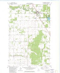
 1985 Hallock1985 Print · USGSNorthwestern Minnesota’s borderlands are captured here in the mid-1980s as a managed landscape of agriculture and conservation. Trace the Burlington Northern line through historic rail towns like Hallock or locate remote airstrips and the expansive Lake Bronson State Park.2 unique versions available
 - 1985 Map of Cavalier
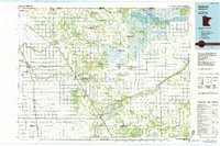
 1985 Cavalier1985 Print · USGSThe Red River Valley and the international border meet in this mid-1980s look at the drainage and rail networks of Northeast North Dakota. Trace the paths of the Burlington Northern and Soo Line through border towns like Neche, Pembina, and Noyes.2 unique versions available
End of results
Showing maps 1-8 of 8
Top cities of Kittson County
- Hallock historical maps
- Karlstad historical maps
- Lancaster historical maps
- Kennedy historical maps
- Lake Bronson historical maps
- Deerwood historical maps
See more
Frequently asked questions
- What are the different types of historical maps available for Kittson County?
- What is the oldest map of Kittson County?
- Where can I purchase historical maps of Kittson County for my home or office?
- Where can I download high-res historical maps of Kittson County?
- Are there historical topographic maps available for Kittson County?
- Is there historical aerial imagery available for Kittson County?
- Where are historical maps of Kittson County sourced from?