1930s Maps of Kittson County, Minnesota
Explore 5 historic maps of Kittson County from the 1930s. These maps offer a rare glimpse into what life looked like during the 1930s — showing old roads, neighborhoods, homes, and landmarks that have changed or disappeared over time.
Whether you're researching your family's past, planning a metal detecting trip, or studying how Kittson County's landscape evolved across the 1930s, these high-resolution maps are a powerful tool for exploring the history of this region.
- Focus on a specific era: All maps on this page are from the 1930s, giving you a focused view of this time period.
- See what’s changed: Compare century-old streets, trails, and buildings to today's modern landscape using overlays and satellite layers.
- Research with precision: Use these maps for genealogy, historical research, land use analysis, or educational projects.
- View, download, or print: Maps are fully viewable online in high resolution, and can be downloaded or printed for your own records.
Start exploring Kittson County's history through authentic maps from the 1930s. This is your window into the past.
Kittson County, MN maps
(5)- 1930 Map of Juneberry
 1930 Juneberry1930 Print · USGSThe northern Minnesota borderlands come into focus at the start of the 1930s, showing the early efforts to drain the vast marshy plains. Genealogists and local historians can locate rural schoolhouses like Oak Point Sch and family-named features such as Johnson Sch and Moose Point.
 - 1932 Map of Juneberry
 1932 Juneberry1932 Print · USGSThe northern Minnesota borderlands and Roseau County wetlands are captured here in the early thirties, just as large-scale drainage projects transformed the terrain. Researchers can trace the rural school system through Oak Point Sch and Johnson Sch, or locate the settlement of Caribou near the Roseau River.2 unique versions available
 - 1939 Map of Drayton, 1954 Print
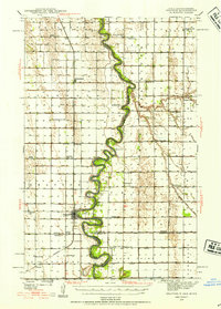 1939 Drayton1954 Print · USGSThe Red River valley at the onset of the Second World War shows a landscape defined by tight river bends and a thriving railroad economy. Genealogists and local historians can trace family locations near dozens of rural schools and churches like Daymon Sch, Tabitha Ch, and the settlement of Bowesmont.2 unique versions available
 - 1939 Map of Pembina, 1958 Print
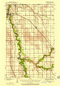 1939 Pembina1958 Print · USGSThe international border at the Red River Valley was a busy corridor of rail and river transit in the late 1930s. Genealogists can locate numerous rural schoolhouses like Fleece Sch and Joe River Sch, or trace the tracks of the Great Northern through St Vincent.3 unique versions available
 - 1939 Map of Kennedy, 1963 Print
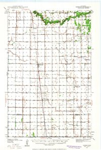 1939 Kennedy1963 Print · USGSUpper Minnesota prairie life is centered on the Great Northern railroad in the years before the war. Genealogists and local historians can trace family roots through numerous country schools and churches like McKinley Sch, Happy Corner, and Enok Ch.2 unique versions available
End of results
Showing maps 1-5 of 5
Top cities of Kittson County
- Hallock historical maps
- Karlstad historical maps
- Lancaster historical maps
- Kennedy historical maps
- Lake Bronson historical maps
- Deerwood historical maps
See more
Frequently asked questions
- What are the different types of historical maps available for Kittson County?
- What is the oldest map of Kittson County?
- Where can I purchase historical maps of Kittson County for my home or office?
- Where can I download high-res historical maps of Kittson County?
- Are there historical topographic maps available for Kittson County?
- Is there historical aerial imagery available for Kittson County?
- Where are historical maps of Kittson County sourced from?