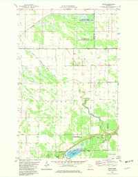
1982 Map of Pelan
USGS Topo · Published 1982About this map
The South Branch Two Rivers meanders through the marshy lowlands of the Pelan and Dewey townships, defining a landscape heavily influenced by drainage management. This early 1980s record shows an extensive network of man-made waterways, including Lateral Ditch No 1 and State Ditch No 95, which crisscross the flat terrain to manage the high water tables of the region. Local history is anchored by the small settlement of Pelan, located near the Kittson and Roseau County line, and the nearby Pioneer Cem. Significant portions of the land are dedicated to conservation, with the Beaches State Wildlife Management Area and Twin Lakes State Wildlife Management Area preserving the area's natural character. To the south, the Twistal Swamp and North Twin Lake provide a sharp contrast to the geometric patterns of the agricultural ditches and several scattered Gravel Pits.
Find a feature on this map
19 named features on this map. Tap any name to fly to it.
Don’t see what you’re looking for? This feature index may not catch every label — zoom into the map to look around manually.
Map Details
Editions of this 1982 Pelan Map
This is the sole edition of this map. No revisions or reprints were ever made.
Other maps of this area

1918 · Hemmington
USGS Topo · 1:62,500

1919 · Pelan
USGS Topo · 1:62,500

1930 · Juneberry
USGS Topo · 1:31,680

1932 · Juneberry
USGS Topo · 1:62,500

1952 · Thief River Falls
USGS Topo · 1:250,000

1956 · Thief River Falls
USGS Topo · 1:250,000

1956 · Karlstad
USGS Topo · 1:62,500

1957 · Thief River Falls
USGS Topo · 1:250,000

1957 · Pelan
USGS Topo · 1:62,500

1966 · Skull Lake SE
USGS Topo · 1:24,000