1960s Maps of Tyler, Minnesota
Explore 2 historic maps of Tyler from the 1960s. These maps offer a rare glimpse into what life looked like during the 1960s — showing old roads, neighborhoods, homes, and landmarks that have changed or disappeared over time.
Whether you're researching your family's past, planning a metal detecting trip, or studying how Tyler's landscape evolved across the 1960s, these high-resolution maps are a powerful tool for exploring the history of this region.
- Focus on a specific era: All maps on this page are from the 1960s, giving you a focused view of this time period.
- See what’s changed: Compare century-old streets, trails, and buildings to today's modern landscape using overlays and satellite layers.
- Research with precision: Use these maps for genealogy, historical research, land use analysis, or educational projects.
- View, download, or print: Maps are fully viewable online in high resolution, and can be downloaded or printed for your own records.
Start exploring Tyler's history through authentic maps from the 1960s. This is your window into the past.
Tyler, MN maps
(2)- 1963 Map of Dead Coon Lake, 1964 Print
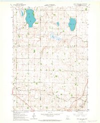 1963 Dead Coon Lake1964 Print · USGSThe town of Tyler and the surrounding Minnesota prairie are captured here in the early 1960s as a hub of rail and drainage. Trace family roots at St Dionysius Cem and Mission Cem, or follow the Chicago and North Western rail line through the marshy terrain of Dead Coon Lake.
 - 1963 Map of Tyler, 1964 Print
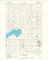 1963 Tyler1964 Print · USGSTyler and the surrounding prairie lakes are shown here in the early sixties, anchored by a vital rail corridor. Genealogists and local historians can trace the town's civic layout through the Danebod Cem, Fairground, and the Chicago and North Western line.
End of results
Showing maps 1-2 of 2
Top cities near Tyler
- Lake Benton historical maps
- Ivanhoe historical maps
- Russell historical maps
- Ruthton historical maps
- Verdi historical maps
- Holland historical maps
See more
Frequently asked questions
- What are the different types of historical maps available for Tyler?
- What is the oldest map of Tyler?
- Where can I purchase historical maps of Tyler for my home or office?
- Where can I download high-res historical maps of Tyler?
- Are there historical topographic maps available for Tyler?
- Is there historical aerial imagery available for Tyler?
- Where are historical maps of Tyler sourced from?