1960s Maps of Morrison County, Minnesota
Explore 12 historic maps of Morrison County from the 1960s. These maps offer a rare glimpse into what life looked like during the 1960s — showing old roads, neighborhoods, homes, and landmarks that have changed or disappeared over time.
Whether you're researching your family's past, planning a metal detecting trip, or studying how Morrison County's landscape evolved across the 1960s, these high-resolution maps are a powerful tool for exploring the history of this region.
- Focus on a specific era: All maps on this page are from the 1960s, giving you a focused view of this time period.
- See what’s changed: Compare century-old streets, trails, and buildings to today's modern landscape using overlays and satellite layers.
- Research with precision: Use these maps for genealogy, historical research, land use analysis, or educational projects.
- View, download, or print: Maps are fully viewable online in high resolution, and can be downloaded or printed for your own records.
Start exploring Morrison County's history through authentic maps from the 1960s. This is your window into the past.
Morrison County, MN maps
(12)- 1963 Map of Motley SE, 1964 Print
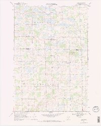
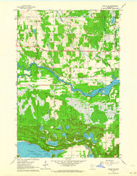 1963 Motley SE1964 Print · USGSThe river and rail corridors of Morrison and Cass counties are frozen in time during the early 1960s. You can trace the Northern Pacific line across the Crow Wing River or locate local landmarks like the Motley Lookout Tower and Camp Shamineau.
 - 1963 Map of Motley, 1964 Print
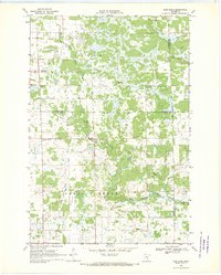
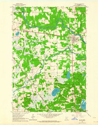 1963 Motley1964 Print · USGSThe confluence of the Crow Wing and Long Prairie Rivers defines this pocket of central Minnesota in the early sixties. Genealogists and local historians can trace the footprint of Motley and Philbrook, along with sites like School No 1212 and St James Cem.2 unique versions available
 - 1965 Map of Stillwater
 1965 Stillwater1965 Print · USGSThe Twin Cities and the St. Croix Valley are mapped here during a period of significant post-war growth and industrial transit. Genealogists and historians can trace rail lines like the Northern Pacific RR through towns such as Rush City, Amery, and Balsam Lake.
 - 1965 Map of Brainerd
 1965 Brainerd1965 Print · USGSNorth-central Minnesota in the mid-fifties presents a complex landscape of sprawling lake systems and established rail corridors. Genealogists and historians can trace the growth of timber towns along the Northern Pacific RR and explore early borders of the White Earth Indian Reservation or Tamarac National Wildlife Refuge.
 - 1968 Map of Ramey NE, 1970 Print
 1968 Ramey NE1970 Print · USGSNear the border of Morrison and Mille Lacs counties in the late sixties, this survey shows a landscape of wetlands and winding brooks. Genealogists and local historians can locate School No 1228, the local Townhall, and early extraction sites like a Sandpit and Gravel Pit.
 - 1968 Map of Platte Lake, 1970 Print
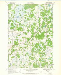
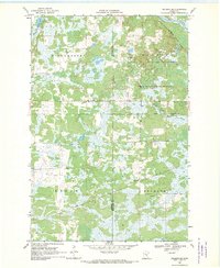
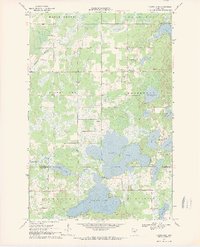 1968 Platte Lake1970 Print · USGSThe lake country of Crow Wing and Morrison Counties is captured here in the late sixties as recreation and local industry shaped the land. Researchers can trace rural landmarks like Pine Center, Emmanuel Ch, and the waters of Platte Lake.2 unique versions available
 - 1968 Map of Ramey NW, 1970 Print
 1968 Ramey NW1970 Print · USGSMorrison County during the late sixties is depicted here as a patchwork of wetland terrain and rural township boundaries. Researchers can trace local landmarks like School No 1220, the winding path of Hillman Creek, and several early Gravel Pits.
 - 1968 Map of Rum River, 1970 Print
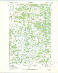
 1968 Rum River1970 Print · USGSCentral Minnesota's river-cut wetlands are captured here in the late sixties at the convergence of three counties. Genealogists and local historians can trace rural civic life through landmarks like Granite Ledge Sch, Lakin Ch, and the local Townhall.
 - 1968 Map of Ramey, 1970 Print
 1968 Ramey1970 Print · USGSBenton and Morrison counties come to life in the late 1960s, showing a transition from old school districts to modern rural roads. Genealogists can trace family roots at Lone Pine Cem, Bethany Ch, and the many hamlets like Ramey and Brennyville.2 unique versions available
 - 1968 Map of Vineland, 1970 Print
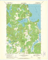 1968 Vineland1970 Print · USGSThe southwestern shores of Mille Lacs Lake are captured here in the late sixties, centered on the settlement of Vineland. Researchers can trace local history through the Alliance Mission, Lakewood Cem, and the boundaries of Mille Lacs Kathio State Park.
 - 1968 Map of Hillman, 1970 Print
 1968 Hillman1970 Print · USGSThe village of Hillman and the surrounding central Minnesota township lands are documented here in the late sixties. Genealogists and researchers can trace the SOO rail line, locate St Rita Cem, and follow the path of the Skunk River past numerous gravel pits.
 - 1968 Map of Hillman SE, 1970 Print
 1968 Hillman SE1970 Print · USGSThe Morrison and Mille Lacs county line in the late sixties reveals a landscape of dense wetlands and state timberlands. Genealogists and historians can trace the Soo Line rail corridor through Johnsdale or locate landmarks like the Gravel Pit and Radio Tower.2 unique versions available
End of results
Showing maps 1-12 of 12
Top cities of Morrison County
- Little Falls historical maps
- Pierz historical maps
- Royalton historical maps
- Cushing historical maps
- Morrill historical maps
- Motley historical maps
See more
Frequently asked questions
- What are the different types of historical maps available for Morrison County?
- What is the oldest map of Morrison County?
- Where can I purchase historical maps of Morrison County for my home or office?
- Where can I download high-res historical maps of Morrison County?
- Are there historical topographic maps available for Morrison County?
- Is there historical aerial imagery available for Morrison County?
- Where are historical maps of Morrison County sourced from?