1970s Maps of Morrison County, Minnesota
Explore 13 historic maps of Morrison County from the 1970s. These maps offer a rare glimpse into what life looked like during the 1970s — showing old roads, neighborhoods, homes, and landmarks that have changed or disappeared over time.
Whether you're researching your family's past, planning a metal detecting trip, or studying how Morrison County's landscape evolved across the 1970s, these high-resolution maps are a powerful tool for exploring the history of this region.
- Focus on a specific era: All maps on this page are from the 1970s, giving you a focused view of this time period.
- See what’s changed: Compare century-old streets, trails, and buildings to today's modern landscape using overlays and satellite layers.
- Research with precision: Use these maps for genealogy, historical research, land use analysis, or educational projects.
- View, download, or print: Maps are fully viewable online in high resolution, and can be downloaded or printed for your own records.
Start exploring Morrison County's history through authentic maps from the 1970s. This is your window into the past.
Morrison County, MN maps
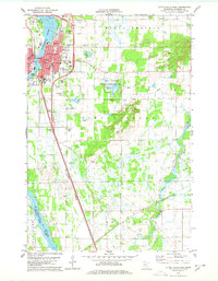
(13)- 1975 Map of Stillwater
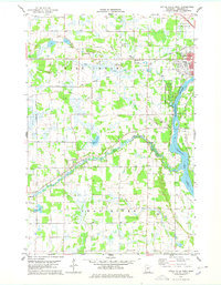
 1975 Stillwater1975 Print · USGSThe Twin Cities and the St. Croix Valley are captured in the mid-seventies, showing the urban growth of Minneapolis and St Paul. Researchers can trace old rail corridors of the Northern Pacific RR and locate tribal lands at the Mille Lacs Indian Reservation.2 unique versions available
 - 1978 Map of Little Falls West
 1978 Little Falls West1978 Print · USGSThe western reaches of Little Falls and the surrounding Morrison County countryside are captured here in the late seventies. Genealogists and local historians can locate Our Lady of Lourdes Cem, the village of Sobieski, and the riverfront at Charles A Lindbergh State Park.2 unique versions available
 - 1978 Map of Royalton
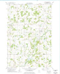
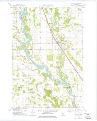 1978 Royalton1978 Print · USGSThe Mississippi and Platte rivers converge in this late 1970s survey of central Minnesota, capturing the rail-and-river economy of the day. Genealogists can trace local roots at Holy Trinity Cem and Royalton Cem, or locate family landmarks near North Prairie and Blanchard Dam.
 - 1978 Map of Little Rock
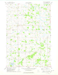 1978 Little Rock1978 Print · USGSBenton and Morrison Counties are captured here in the late seventies, showing a quiet landscape of prairie creeks and rural townships. Researchers can trace local roots at St Johns Cem and Graham Ch or explore the wetlands of the Wisneski State Wildlife Management Area.
 - 1978 Map of Pierz Lake
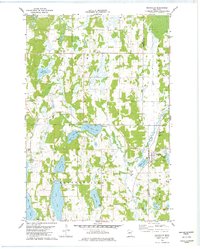
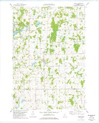
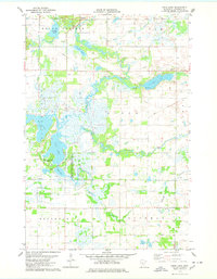 1978 Pierz Lake1978 Print · USGSMorrison County's lake-and-river landscape is captured here in the late seventies, centered on the complex wetlands and riparian corridors of the Skunk River. Researchers can trace the path of the Soo Line railroad near the settlement of Vawter and locate family landmarks like Pelkey Lake or Frieze Lake.
 - 1978 Map of Bowlus
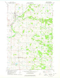
 1978 Bowlus1978 Print · USGSMorrison County's rural rail and river landscape is preserved here in the late seventies, centered on the Soo Line through Bowlus. Genealogists and local historians can locate St Mary Cem, South Elmdale Sch, and the village of Elmdale.
 - 1978 Map of Swanville
 1978 Swanville1978 Print · USGSThe borderlands of Todd and Morrison Counties come into focus in the late 1970s, showcasing a landscape defined by the Swan River and glacial lakes. Researchers can trace local lineage at Bearhead Cem or explore the settlements of Swanville and Pillsbury.
 - 1978 Map of Pierz
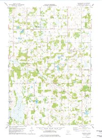
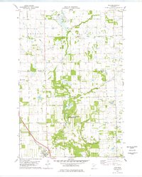
 1978 Pierz1978 Print · USGSMorrison County's agricultural and rail landscape is captured here in the late seventies as the Soo Line tracks linked the rural communities of Pierz and Genola. Researchers can trace the wetlands of the Coon Lake State Wildlife Management Area and find local industry at several Gravel Pits.
 - 1978 Map of Flensburg
 1978 Flensburg1978 Print · USGSIn the late seventies, this part of Morrison County was defined by its small prairie townships and the winding Swan River. Genealogists and local historians can trace the foundations of Flensburg and Sobieski or find family plots at Sacred Heart Cem.
 - 1978 Map of Upsala
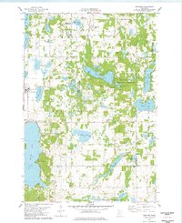
 1978 Upsala1978 Print · USGSCentral Minnesota farm and lake country comes to life in the late seventies, centered on the village of Upsala. Genealogists and local researchers can pinpoint family landmarks like St Marys Cem, the St Francis church, and Lake Beautiful.
 - 1978 Map of Little Falls East
 1978 Little Falls East1978 Print · USGSLittle Falls and the surrounding Morrison County prairies are captured here in the late seventies. Genealogists can locate several local burial grounds like Oakland Cem and St Marys Cem, or trace the tracks of the Soo Line and Burlington Northern railroads.2 unique versions available
 - 1978 Map of Burtrum
 1978 Burtrum1978 Print · USGSThe lake-strewn landscape of central Minnesota is seen here in the late seventies at the junction of three counties. Local historians can trace the lakeside developments at North Shore and Pleasant Beach or locate family sites near the G A R Cem and Burtrum.
 - 1978 Map of Rice
 1978 Rice1978 Print · USGSBenton County in the late seventies is captured here as a landscape of rural townships and winding waterways. Researchers can trace the Burlington Northern rail line through Rice, locate Skounter Hill, or explore the Sartell Swamp wetlands.
End of results
Showing maps 1-13 of 13
Top cities of Morrison County
- Little Falls historical maps
- Pierz historical maps
- Royalton historical maps
- Cushing historical maps
- Morrill historical maps
- Motley historical maps
See more
Frequently asked questions
- What are the different types of historical maps available for Morrison County?
- What is the oldest map of Morrison County?
- Where can I purchase historical maps of Morrison County for my home or office?
- Where can I download high-res historical maps of Morrison County?
- Are there historical topographic maps available for Morrison County?
- Is there historical aerial imagery available for Morrison County?
- Where are historical maps of Morrison County sourced from?