1980s Maps of Mower County, Minnesota
Explore 10 historic maps of Mower County from the 1980s. These maps offer a rare glimpse into what life looked like during the 1980s — showing old roads, neighborhoods, homes, and landmarks that have changed or disappeared over time.
Whether you're researching your family's past, planning a metal detecting trip, or studying how Mower County's landscape evolved across the 1980s, these high-resolution maps are a powerful tool for exploring the history of this region.
- Focus on a specific era: All maps on this page are from the 1980s, giving you a focused view of this time period.
- See what’s changed: Compare century-old streets, trails, and buildings to today's modern landscape using overlays and satellite layers.
- Research with precision: Use these maps for genealogy, historical research, land use analysis, or educational projects.
- View, download, or print: Maps are fully viewable online in high resolution, and can be downloaded or printed for your own records.
Start exploring Mower County's history through authentic maps from the 1980s. This is your window into the past.
Mower County, MN maps
(10)- 1982 Map of Austin East, 1983 Print
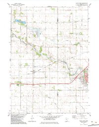
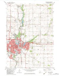 1982 Austin East1983 Print · USGSAustin and its surrounding Mower County townships are captured here in the early 1980s, centered on the busy Cedar River corridor. Researchers can trace local landmarks like Oakwood Cem, the Drive-in Theater, and the Austin Municipal Airport.
 - 1982 Map of London, 1983 Print
 1982 London1983 Print · USGSSouthern Minnesota prairie and borderlands are captured here in the early eighties, showing the agricultural grids of London and Myrtle. Researchers can locate several family and community landmarks like London Cem, Woodbury Cem, and the Trondhjem Ch.
 - 1982 Map of Brownsdale, 1983 Print
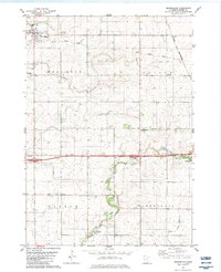 1982 Brownsdale1983 Print · USGSMower County farming and rail history are preserved here during the early eighties. Genealogists can locate family landmarks such as Brown Cem and Hoflanda Ch, or trace the path of the Chicago and North Western through Renova.
 - 1982 Map of Lyle, 1983 Print
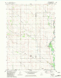
 1982 Lyle1983 Print · USGSSouthern Minnesota's agricultural landscape is documented here in the early 1980s, centered on the railroad town of Lyle. Genealogists can trace family landmarks like Sixmile Grove Ch, the Rose Creek Cem, and small rural stops like Baldner.
 - 1982 Map of Austin West, 1983 Print
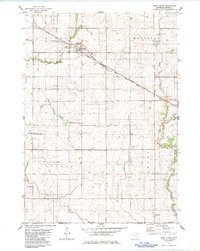
 1982 Austin West1983 Print · USGSThe western outskirts of Austin and the small rail stops of Freeborn County are captured here in the early 1980s. Researchers can trace family history at Fairview Cem or locate the site of the Vo-Tech Sch and the neighborhood of Austin Acres.
 - 1982 Map of Rose Creek, 1983 Print
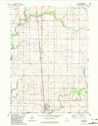
 1982 Rose Creek1983 Print · USGSSouthern Minnesota farmland meets the Iowa border in the early 1980s, centered on the rail-side community of Rose Creek. Genealogists and local historians can trace the tracks of the Milwaukee Road, locate the rural Johnsburg settlement, and find family markers at St Peter Cem.
 - 1985 Map of Mason City
 1985 Mason City1985 Print · USGSThe Northern Iowa and Southern Minnesota borderlands are captured here in the mid-eighties, showing a region defined by agricultural drainage and rail heritage. Genealogists and historians can trace the grid of rural townships and find local landmarks like Pilot Knob State Park, Nora Springs, and Clear Lake State Park.2 unique versions available
 - 1985 Map of Charles City
 1985 Charles City1985 Print · USGSNorthern Iowa and the Minnesota borderlands are mapped here in the mid-1980s as a thriving network of rail-side towns and river valleys. Trace local history through the Reilly Settlement, Stacyville Junction, and aviation sites like Ellen Church Field.2 unique versions available
 - 1985 Map of Albert Lea
 1985 Albert Lea1985 Print · USGSSouthern Minnesota's agricultural heartland is documented here in the mid-1980s, showing a landscape defined by industrial rail lines and managed waterways. Trace the historic routes of the Chicago and North Western and explore settlements like Hollandale, New Richland, and Bricelyn.2 unique versions available
 - 1985 Map of Austin
 1985 Austin1985 Print · USGSSoutheast Minnesota in the mid-1980s reveals a land of river valleys and agricultural hubs along the Iowa border. Researchers can trace the legacy of regional transport through the Chicago and North Western line and landmarks like Niagara Cave or the Rochester Municipal Airport.2 unique versions available
End of results
Showing maps 1-10 of 10
Top cities of Mower County
- Austin historical maps
- Lansing historical maps
- Grand Meadow historical maps
- Le Roy historical maps
- Adams historical maps
- Brownsdale historical maps
See more
Frequently asked questions
- What are the different types of historical maps available for Mower County?
- What is the oldest map of Mower County?
- Where can I purchase historical maps of Mower County for my home or office?
- Where can I download high-res historical maps of Mower County?
- Are there historical topographic maps available for Mower County?
- Is there historical aerial imagery available for Mower County?
- Where are historical maps of Mower County sourced from?