1960s Maps of Mower County, Minnesota
Explore 9 historic maps of Mower County from the 1960s. These maps offer a rare glimpse into what life looked like during the 1960s — showing old roads, neighborhoods, homes, and landmarks that have changed or disappeared over time.
Whether you're researching your family's past, planning a metal detecting trip, or studying how Mower County's landscape evolved across the 1960s, these high-resolution maps are a powerful tool for exploring the history of this region.
- Focus on a specific era: All maps on this page are from the 1960s, giving you a focused view of this time period.
- See what’s changed: Compare century-old streets, trails, and buildings to today's modern landscape using overlays and satellite layers.
- Research with precision: Use these maps for genealogy, historical research, land use analysis, or educational projects.
- View, download, or print: Maps are fully viewable online in high resolution, and can be downloaded or printed for your own records.
Start exploring Mower County's history through authentic maps from the 1960s. This is your window into the past.
Mower County, MN maps
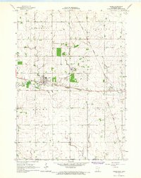
(9)- 1965 Map of Le Roy, 1966 Print
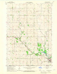 1965 Le Roy1966 Print · USGSLe Roy was a bustling rail hub in the mid-1960s, situated at the junction of two major lines near the Iowa border. Genealogists and historians can trace local families through St Patricks Cem or explore the early layout of Lake Louise State Park.
 - 1965 Map of Dexter, 1966 Print
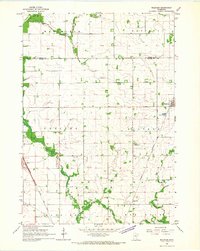
 1965 Dexter1966 Print · USGSMower County in the mid-1960s reveals a landscape where traditional rail hubs like Dexter and Elkton begin to adapt to the arrival of Interstate 90. Genealogists and historians can locate the Dexter Cemetery and St John Church, or trace the diverging routes of the Chicago Great Western and Milwaukee railroads.
 - 1965 Map of Spring Valley, 1966 Print
 1965 Spring Valley1966 Print · USGSSpring Valley and the surrounding townships in the mid-1960s reveal a landscape shaped by a major railroad junction and rural industry. Researchers can trace historic family burial sites like Frankford Cem and Bloomfield Cem or locate old infrastructure like the Townhall.
 - 1965 Map of Grand Meadow, 1966 Print
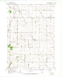
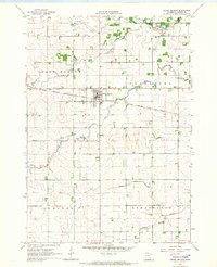 1965 Grand Meadow1966 Print · USGSMower County farming and rail life are detailed here during the mid-1960s, centered on the village of Grand Meadow. Genealogists and local historians can locate St Finbarrs Cem, Bear Creek Ch, and the winding South Branch Root River.
 - 1965 Map of Ostrander, 1966 Print
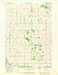 1965 Ostrander1966 Print · USGSThe borderlands of Fillmore County and Iowa are captured here in the mid-sixties, dominated by rail lines and winding river branches. Researchers can pinpoint early landmarks like Bloomfield Cem, the Ostrander rail corridor, and various Quarry sites.
 - 1965 Map of Adams, 1967 Print
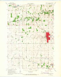
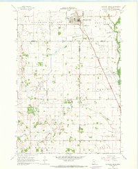
 1965 Adams1967 Print · USGSSoutheast Minnesota's prairie border is shown here in the mid-1960s, where the grain-hauling rail lines of the era intersect at the village of Adams. Genealogists and researchers can trace the vicinity of Taopi, local churches like Marshall Ch, and the Woodlawn Cem.2 unique versions available
 - 1966 Map of Waltham, 1967 Print
 1966 Waltham1967 Print · USGSSouthern Minnesota's agricultural heartland is documented here during the mid-1960s, showing the vital rail links and small townships of Mower and Dodge Counties. Researchers can trace local genealogy and land use through landmarks like St Michaels Ch, the village of Waltham, and the Chicago Great Western tracks.
 - 1966 Map of Sargeant, 1967 Print
 1966 Sargeant1967 Print · USGSSoutheastern Minnesota farmland near the Dodge and Mower county line is captured here in the mid-sixties. Genealogists and local historians can trace the Chicago Great Western rail line and locate community landmarks like St Johns Ch and the Waltham Cem.
 - 1967 Map of Blooming Prairie, 1968 Print
 1967 Blooming Prairie1968 Print · USGSThe fertile farmlands surrounding Blooming Prairie were captured in the late sixties, showing the vital link between the Chicago Milwaukee St Paul and Pacific rail line and the prairie economy. Local historians can trace family-named landmarks and rural hubs like Red Oak Grove Ch and Selstad Landing Field.
End of results
Showing maps 1-9 of 9
Top cities of Mower County
- Austin historical maps
- Lansing historical maps
- Grand Meadow historical maps
- Le Roy historical maps
- Adams historical maps
- Brownsdale historical maps
See more
Frequently asked questions
- What are the different types of historical maps available for Mower County?
- What is the oldest map of Mower County?
- Where can I purchase historical maps of Mower County for my home or office?
- Where can I download high-res historical maps of Mower County?
- Are there historical topographic maps available for Mower County?
- Is there historical aerial imagery available for Mower County?
- Where are historical maps of Mower County sourced from?