
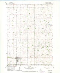
1966 Map of Waltham
USGS Topo · Published 1967About this map
The Cedar River meanders through this portion of Mower and Dodge Counties, shaping a landscape defined by organized rural sections and small agricultural hubs during the mid-1960s. The village of Waltham serves as a primary center of activity, while the smaller settlement of Mayville sits further south along the Chicago Great Western railroad line. This period captures the rail-dependent economy of southern Minnesota, with the Chicago Milwaukee St Paul and Pacific corridor also cutting through the western township of Udolpho.
Find a feature on this map
24 named features on this map. Tap any name to fly to it.
Don’t see what you’re looking for? This feature index may not catch every label — zoom into the map to look around manually.
Map Details
Editions of this 1966 Waltham Map
This is the sole edition of this map. No revisions or reprints were ever made.
Other maps of this area

1954 · Hayward
USGS Topo · 1:62,500

1954 · Austin
USGS Topo · 1:62,500

1954 · Mason City
USGS Topo · 1:250,000

1957 · Mason City
USGS Topo · 1:250,000

1958 · Mason City
USGS Topo · 1:250,000

1966 · Hayfield NW
USGS Topo · 1:24,000
1966 · Hayfield
USGS Topo · 1:24,000

1966 · Sargeant
USGS Topo · 1:24,000

1967 · Bixby
USGS Topo · 1:24,000

1967 · Blooming Prairie
USGS Topo · 1:24,000