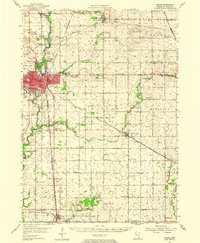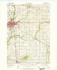
1954 Map of Austin
USGS Topo · Published 1956About this map
The mid-century layout of Austin serves as the focal point of this 1954 survey, showcasing a thriving hub at the intersection of several major rail lines including the Chicago Milwaukee St Paul and Pacific and the Chicago Great Western. The city’s development is captured in detail, from the Jr College and Municipal Airport to local social fixtures like the Austin Country Club and the Drive-in Theater. Surrounding the urban center, the landscape is defined by the Cedar River and Turtle Creek, which wind through a patchwork of agricultural townships.
Find a feature on this map
75 named features on this map. Tap any name to fly to it.
Don’t see what you’re looking for? This feature index may not catch every label — zoom into the map to look around manually.
Map Details
Editions of this 1954 Austin Map
2 editions found