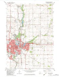
1982 Map of Austin East
USGS Topo · Published 1983About this map
The Cedar River and its various tributaries shape this landscape, flowing through the heart of Austin and supporting industry and recreation alike. In the early 1980s, the city is a hub of civic and educational activity, evidenced by the Austin State Junior College, St Olaf Hosp, and numerous schools like Pacelli High Sch. The map reveals a community deeply connected to its water, from the industrial Powerplant and Ramsey Mill Pond in the north to the East Side Lake reservoir. Transportation networks are prominent, including the Chicago Milwaukee St Paul and Pacific Railroad and the Austin Municipal Airport. Outlying settlements like Lansing, Ramsey, and Brownsdale illustrate the transition from the dense urban center to the surrounding agricultural townships of Lansing and Red Rock.
Find a feature on this map
70 named features on this map. Tap any name to fly to it.
Don’t see what you’re looking for? This feature index may not catch every label — zoom into the map to look around manually.
Map Details
Editions of this 1982 Austin East Map
This is the sole edition of this map. No revisions or reprints were ever made.
Other maps of this area

1954 · Hayward
USGS Topo · 1:62,500

1954 · Austin
USGS Topo · 1:62,500

1954 · Mason City
USGS Topo · 1:250,000

1957 · Mason City
USGS Topo · 1:250,000

1958 · Mason City
USGS Topo · 1:250,000

1966 · Waltham
USGS Topo · 1:24,000

1966 · Sargeant
USGS Topo · 1:24,000

1967 · Blooming Prairie
USGS Topo · 1:24,000
1982 · London
USGS Topo · 1:24,000
1982 · Brownsdale
USGS Topo · 1:24,000