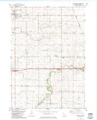
1982 Map of Brownsdale
USGS Topo · Published 1983About this map
Brownsdale and its surrounding agricultural townships serve as the center of this early 1980s Mower County survey. The landscape is defined by the drainage patterns of Wolf Creek and Dobbins Creek, which flow through the territories of Red Rock and Dexter. This era shows a transition in local transportation, where the active Chicago and North Western line crosses paths with an Old Railroad Grade, tracing the evolution of the region's rail-dependent economy. For those researching local heritage, the map identifies several rural landmarks including Hoflanda Ch and Trinity Evangelical Ch, alongside established burial grounds like Brown Cem and Greenwood Cem. Small settlements such as Renova and Nicolville appear as concentrated points of habitation amidst the broad farm tracts of Windom and Marshall townships.
Find a feature on this map
21 named features on this map. Tap any name to fly to it.
Don’t see what you’re looking for? This feature index may not catch every label — zoom into the map to look around manually.
Map Details
Editions of this 1982 Brownsdale Map
This is the sole edition of this map. No revisions or reprints were ever made.
Other maps of this area

1954 · Austin
USGS Topo · 1:62,500

1954 · Mason City
USGS Topo · 1:250,000

1955 · High Forest
USGS Topo · 1:62,500

1957 · Mason City
USGS Topo · 1:250,000

1958 · Mason City
USGS Topo · 1:250,000

1965 · Dexter
USGS Topo · 1:24,000

1965 · Adams
USGS Topo · 1:24,000

1966 · Waltham
USGS Topo · 1:24,000

1966 · Sargeant
USGS Topo · 1:24,000
1974 · High Forest SW
USGS Topo · 1:24,000